Login
Register
CAO
Clayton Municipal Airpark Airport
Official FAA Data Effective 2025-11-27 0901Z
VFR Chart of KCAO
Sectional Charts at SkyVector.com
IFR Chart of KCAO
Enroute Charts at SkyVector.com
Location Information for KCAO
Coordinates: N36°26.78' / W103°9.00'Located 02 miles E of Clayton, New Mexico on 755 acres of land. View all Airports in New Mexico.
Surveyed Elevation is 4969 feet MSL.
Operations Data
|
|
Airport Communications
| ASOS: | 120.625 Tel. 575-446-3045 |
|---|---|
| UNICOM: | 122.800 |
| CTAF: | 122.800 |
| ASOS at DHT (38.7 SE): | 134.075 806-249-5671 |
| AWOS-3 at DUX (65.5 SE): | 118.075 806-934-3390 |
| ASOS at RTN (67.6 W): | 118.375 575-303-2003 |
- APCH/DEP SVC PRVDD BY ALBUQUERQUE ARTCC (ABQ) ON FREQS 127.85/285.475 (MOUNT DORA RCAG).
Nearby Navigation Aids
|
| ||||||||||||||||||||||||||||||||||||||||||
Runway 02/20
| Dimensions: | 6307 x 75 feet / 1922 x 23 meters | |
|---|---|---|
| Surface: | Asphalt in Fair Condition | |
| Weight Limits: | 6 /F/C/Y/T, S-16 | |
| Edge Lighting: | Medium Intensity | |
| Runway 02 | Runway 20 | |
| Coordinates: | N36°26.33' / W103°9.47' | N36°27.23' / W103°8.83' |
| Elevation: | 4965.7 | 4969.8 |
| Traffic Pattern: | Left | Left |
| Runway Heading: | 30° True | 210° True |
| Displaced Threshold: | 390 Feet | |
| Markings: | Non-Precision Instrument in good condition. | Non-Precision Instrument in good condition. |
| Glide Slope Indicator | P2L (3.05° Glide Path Angle) | P2L (3.05° Glide Path Angle) |
Runway 12/30
| Dimensions: | 4105 x 60 feet / 1251 x 18 meters | |
|---|---|---|
| Surface: | Asphalt in Fair Condition | |
| Weight Limits: | 5 /F/D/Y/T | |
| Edge Lighting: | Medium Intensity | |
| Runway 12 | Runway 30 | |
| Coordinates: | N36°26.99' / W103°9.08' | N36°26.55' / W103°8.44' |
| Elevation: | 4966.1 | 4946.8 |
| Runway Heading: | 130° True | 310° True |
| Markings: | Basic in fair condition. | Basic in fair condition. |
Services Available
| Fuel: | 100LL (blue), Jet-A |
|---|---|
| Transient Storage: | Tiedowns |
| Airframe Repair: | NOT AVAILABLE |
| Engine Repair: | NOT AVAILABLE |
| Bottled Oxygen: | NOT AVAILABLE |
| Bulk Oxygen: | NOT AVAILABLE |
Ownership Information
| Ownership: | Publicly owned | |
|---|---|---|
| Owner: | TOWN OF CLAYTON | FERON LUCERO. |
| 1 CHESTNUT ST | ||
| CLAYTON, NM 88415 | ||
| 575-374-8331 | ||
| Manager: | ALYSSA MYERS | |
| 1 CHESTNUT ST | ||
| CLAYTON, NM 88415 | ||
| 575-374-9873 | ALT PHONE: 575-429-9635 MGR CELL PHONE. | |
Other Remarks
- REFLECTORS ALL TWYS.
- FOR CD CTC ALBUQUERQUE ARTCC AT 505-856-4861.
- 0LL 100 LL & JET A AVBL 24-7 SELF-SVC WITH MAJOR CREDIT CARD.
- ACTVT PAPI RWY 02 & 20; MIRL RWY 02/20 & 12/30 - CTAF.
Weather Minimums
Instrument Approach Procedure (IAP) Charts
Nearby Airports with Instrument Procedures
| ID | Name | Heading / Distance | ||
|---|---|---|---|---|
 |
17K | Boise City Airport | 057° | 36.6 |
 |
KDHT | Dalhart Municipal Airport | 130° | 38.7 |
 |
KDUX | Moore County Airport | 122° | 65.5 |
 |
8V7 | Springfield Municipal Airport | 022° | 65.8 |
 |
KRTN | Raton Municipal/Crews Field Airport | 285° | 67.7 |
 |
KEHA | Elkhart-Morton County Airport | 061° | 69.7 |
 |
KTAD | Perry Stokes Airport | 310° | 75.2 |
 |
KTCC | Tucumcari Municipal Airport | 196° | 78.9 |
 |
KGUY | Guymon Municipal Airport | 079° | 80.7 |
 |
E19 | Gruver Municipal Airport | 098° | 84.2 |
 |
E42 | Major Samuel B Cornelius Field Airport | 097° | 95.8 |
 |
KHQG | Hugoton Municipal Airport | 062° | 95.9 |


Comments
Nice Place to Stop or Stay
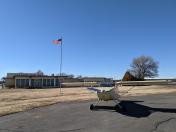
Nice runways. Decent terminal with facilities. I had a pleasant chat with the airport manager and a resident pilot. Great place for a break or stop over.