Login
Register


D25
Manitowish Waters Airport
Official FAA Data Effective 2026-02-19 0901Z
Chart Supplement

VFR Chart of D25
Sectional Charts at SkyVector.com
IFR Chart of D25
Enroute Charts at SkyVector.com
Location Information for D25
Coordinates: N46°7.21' / W89°52.93'Located 01 miles S of Manitowish Waters, Wisconsin on 439 acres of land. View all Airports in Wisconsin.
Surveyed Elevation is 1610 feet MSL.
Operations Data
|
|
Airport Communications
| AWOS-3PT: | 118.175 Tel. 715-543-2004 |
|---|---|
| UNICOM: | 122.800 |
| CTAF: | 122.800 |
| AWOS-3 at ARV (13.2 SE): | 121.125 715-356-2417 |
| AWOS-3PT at IWD (26.5 N): | 125.175 906-932-4039 |
| AWOS-3 at EGV (28.0 SE): | 118.325 715-479-1465 |
- APCH/DEP SVC PRVDD BY MINNEAPOLIS ARTCC ON FREQS 133.65/281.5 (RHINELANDER RCAG).
Nearby Navigation Aids
|
| ||||||||||||||||||||||||||||||||||||||||||||||||


Runway 14/32
| Dimensions: | 3498 x 60 feet / 1066 x 18 meters | |
|---|---|---|
| Surface: | Asphalt in Excellent Condition | |
| Weight Limits: | S-12 | |
| Edge Lighting: | Medium Intensity | |
| Runway 14 | Runway 32 | |
| Coordinates: | N46°7.52' / W89°53.31' | N46°7.07' / W89°52.80' |
| Elevation: | 1609.6 | 1610.2 |
| Runway Heading: | 141° True | 321° True |
| Markings: | Non-Precision Instrument in good condition. | Non-Precision Instrument in good condition. |
| Glide Slope Indicator | P2L (3.50° Glide Path Angle) | P2L (3.50° Glide Path Angle) |
| REIL: | Yes | Yes |
| Obstacles: | 70 ft Trees 1575 ft from runway, 50 ft left of center | |
Runway 04/22
CLSD IN WINTER. | ||
| Dimensions: | 3094 x 120 feet / 943 x 37 meters | |
|---|---|---|
| Surface: | Turf in Good Condition | |
| Runway 04 | Runway 22 | |
| Coordinates: | N46°6.93' / W89°53.04' | N46°7.31' / W89°52.54' |
| Elevation: | 1607.6 | 1609.8 |
| Traffic Pattern: | Left | Left |
| Runway Heading: | 43° True | 223° True |
| Markings: | None | None |
| Obstacles: | 45 ft Trees 450 ft from runway, 80 ft left of center | 85 ft Trees 1120 ft from runway, 200 ft left of center |
Services Available
| Fuel: | 100LL (blue) |
|---|---|
| Transient Storage: | Tiedowns |
| Airframe Repair: | NONE |
| Engine Repair: | NONE |
| Bottled Oxygen: | NOT AVAILABLE |
| Bulk Oxygen: | NOT AVAILABLE |
Ownership Information
| Ownership: | Publicly owned | |
|---|---|---|
| Owner: | TOWN OF MANITOWISH WATERS | |
| P O BOX 267 | ||
| MANITOWISH WATERS, WI 54545 | ||
| 715-543-8400 | ||
| Manager: | JOHN HANSON | |
| P.O. BOX 267 | ||
| MANITOWISH WATERS, WI 54545 | ||
| 715-904-0502 | ||
Other Remarks
- 122 FT AGL/1737 FT MSL TWR APRXLY 1000 FT E OF ARPT.
- DEER & COYOTES ON & INVOF ARPT.
- BIRDS AND MIGRATORY WATERFOWL ON & INVOF ARPT.
- FOR CD CTC MINNEAPOLIS ARTCC AT 651-463-5588.
- MKD WITH YELLOW CONES.
- MKD WITH YELLOW CONES.
- 0LL 24 HR SELF SVC FUEL AVBL WITH CREDIT CARD.
- MIRL RWY 14/32 PRESET TO LOW SS-SR; TO INCR INTST & ACTVT REIL RWY 14 & 32; PAPI RWY 14 & 32; MIRL RWY 14/32 - CTAF.
Weather Minimums

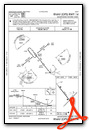
Instrument Approach Procedure (IAP) Charts

Nearby Airports with Instrument Procedures
| ID | Name | Heading / Distance | ||
|---|---|---|---|---|
 |
KARV | Lakeland/Noble F Lee Memorial Field Airport | 151° | 13.2 |
|
KPKF | Park Falls Municipal Airport | 246° | 24.7 |
|
KIWD | Gogebic/Iron County Airport | 337° | 26.5 |
|
KLNL | Kings Land O' Lakes Airport | 085° | 28.0 |
|
KEGV | Eagle River Union Airport | 113° | 28.0 |
|
KPBH | Price County Airport | 221° | 32.9 |
|
KRHI | Rhinelander/Oneida County Airport | 149° | 34.1 |
|
KTKV | Tomahawk Regional Airport | 175° | 39.2 |
|
KOGM | Ontonagon County/Schuster Field Airport | 025° | 48.5 |
|
KASX | John F Kennedy Memorial Airport | 301° | 50.2 |
|
Y55 | Crandon/Steve Conway Municipal Airport | 131° | 53.7 |
|
4R5 | Major Gilbert Field Airport | 318° | 54.1 |
Airport Images
Do you have a recent image of this airport? Upload it here!


