Login
Register
51G
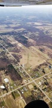
Alkay Airport
Official FAA Data Effective 2025-11-27 0901Z
VFR Chart of 51G
Sectional Charts at SkyVector.com
IFR Chart of 51G
Enroute Charts at SkyVector.com
Location Information for 51G
Coordinates: N43°8.60' / W83°47.82'Located 03 miles SW of Clio, Michigan on 95 acres of land. View all Airports in Michigan.
Estimated Elevation is 714 feet MSL.
Operations Data
|
|
Airport Communications
| CTAF: | 122.900 |
|---|---|
| ASOS at FNT (10.7 S): | 810-202-2914 |
| ATIS at FNT (10.9 S): | 133.15 |
| AWOS-3 at RNP (17.3 SW): | 118.025 989-729-2967 |
Nearby Navigation Aids
|
| ||||||||||||||||||||||||||||||||||||||||||||||||||||||
Runway 03/21
IREG, DEFINED BY MOWING. | ||
| Dimensions: | 1933 x 100 feet / 589 x 30 meters | |
|---|---|---|
| Surface: | Turf in Poor Condition ROUGH. | |
| Runway 03 | Runway 21 | |
| Coordinates: | N43°8.51' / W83°47.91' | N43°8.78' / W83°47.68' |
| Traffic Pattern: | Left | Left |
| Runway Heading: | 32° True | 212° True |
| Markings: | None | None |
| Obstacles: | 61 ft Tree 600 ft from runway CTLG OBSTN EXCEEDS A 45 DEG SLP. |
15 ft Building 10 ft from runway, 120 ft left of center |
Runway 14/32
IREG, DEFINED BY MOWING. | ||
| Dimensions: | 1895 x 140 feet / 578 x 43 meters | |
|---|---|---|
| Surface: | Turf in Poor Condition ROUGH; AER 32 WET IN SPRING AFT RAIN. | |
| Runway 14 | Runway 32 | |
| Coordinates: | N43°8.70' / W83°47.91' | N43°8.46' / W83°47.64' |
| Traffic Pattern: | Left | Left |
| Runway Heading: | 140° True | 320° True |
| Markings: | None | None |
| Obstacles: | 85 ft Tree 711 ft from runway, 10 ft left of center CTLG OBSTN EXCEEDS A 45 DEG SLP. |
43 ft Trees 0 ft from runway, 53 ft right of center |
Runway 18/36
| Dimensions: | 1800 x 100 feet / 549 x 30 meters | |
|---|---|---|
| Surface: | Turf in Fair Condition | |
| Runway 18 | Runway 36 | |
| Coordinates: | N43°8.74' / W83°47.90' | N43°8.44' / W83°47.89' |
| Elevation: | 709.0 | 714.0 |
| Traffic Pattern: | Left | Left |
| Runway Heading: | 179° True | 359° True |
| Displaced Threshold: | 600 Feet | 100 Feet |
| Obstacles: | 45 ft Trees 288 ft from runway, 100 ft right of center | 66 ft Trees 0 ft from runway, 100 ft left of center CTLG OBSTN EXCEEDS A 45 DEG SLP. |
Services Available
| Fuel: | NONE |
|---|---|
| Transient Storage: | Tiedowns |
| Airframe Repair: | NONE |
| Engine Repair: | NONE |
| Bottled Oxygen: | NONE |
| Bulk Oxygen: | NONE |
Ownership Information
| Ownership: | Privately Owned | |
|---|---|---|
| Owner: | DOUGLAS SMITH | |
| 5480 W DODGE RD | ||
| CLIO, MI 48420-8558 | ||
| 810-444-7196 | ||
| Manager: | DOUGLAS SMITH | |
| 5480 W DODGE RD | ||
| CLIO, MI 48420-8558 | ||
| 810-444-7196 | ||
Other Remarks
- DEER & LRG BIRDS ON & INVOF ARPT.
- RWYS 03/21 & 14/32 LCL USE ONLY; NOT STATE LICENSED.
- FOR CD CTC GREAT LAKES APCH AT 269-459-3345, WHEN APCH CLSD CTC CLEVELAND ARTCC AT 440-774-0224/0490.
- CK NOTAMS FOR FLD CONDS DURG WINTER MONTHS - NO SNOW REMOVAL.
- 3 FT YELLOW CONES.
- 3 FT YELLOW CONES.
Nearby Airports with Instrument Procedures
| ID | Name | Heading / Distance | ||
|---|---|---|---|---|
 |
KFNT | Bishop International Airport | 167° | 10.9 |
 |
KRNP | Owosso Community Airport | 239° | 17.5 |
 |
KHYX | Saginaw County/H W Browne Airport | 350° | 17.6 |
 |
9G2 | Prices Airport | 176° | 20.2 |
 |
D95 | Dupont/Lapeer Airport | 101° | 23.6 |
 |
KCFS | Tuscola Area Airport | 039° | 24.4 |
 |
3CM | James Clements Municipal Airport | 349° | 24.6 |
 |
KMBS | Mbs International Airport | 332° | 26.4 |
 |
KOZW | Livingston County Spencer J Hardy Airport | 194° | 31.9 |
 |
77G | Marlette Township Airport | 071° | 32.6 |
 |
KPTK | Oakland County International Airport | 149° | 33.1 |
 |
KIKW | Jack Barstow Airport | 327° | 37.2 |


