Login
Register
74II
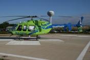
Hendricks Community Hospital Heliport
Official FAA Data Effective 2025-12-25 0901Z
VFR Chart of 74II
Sectional Charts at SkyVector.com
IFR Chart of 74II
Enroute Charts at SkyVector.com
Location Information for 74II
Coordinates: N39°45.83' / W86°30.07'Located 01 miles E of Danville, Indiana. View all Airports in Indiana.
Estimated Elevation is 893 feet MSL.
Operations Data
|
|
Airport Communications
| AWOS-3PT at 2R2 (1.5 SE): | 118.025 317-718-4872 |
|---|---|
| D-ATIS at IND (9.9 E): | 134.25 |
| ASOS at IND (9.9 E): | 317-220-6243 |
Nearby Navigation Aids
|
| ||||||||||||||||||||||||||||||||||||||||||||||||||||||||||||
Helipad H1
| Dimensions: | 54 x 54 feet / 16 x 16 meters | |
|---|---|---|
| Surface: | Concrete | |
| Coordinates: | N39°45.83' / W86°30.07' | N0°0.00' / E0°0.00' |
| Elevation: | 893.0 | |
Helipad H2
| Dimensions: | 50 x 50 feet / 15 x 15 meters | |
|---|---|---|
| Surface: | Asphalt-Concrete | |
| Coordinates: | N39°45.82' / W86°30.07' | N0°0.00' / E0°0.00' |
| Elevation: | 839.0 | |
Ownership Information
| Ownership: | Privately Owned | |
|---|---|---|
| Owner: | HENDRICKS REGIONAL HEALTH | |
| 1000 EAST MAIN ST | ||
| DANVILLE, IN 46122 | ||
| (317) 745-3764 | ||
| Manager: | TROY TUCKER | |
| 1000 EAST MAIN ST | ||
| DANVILLE, IN 46122 | ||
| (317) 745-3764 | ||
Other Remarks
- NO OVERFLIGHT OF HOSPITAL STRUCTURE
- FOR CD CTC INDIANAPOLIS APCH AT 317-227-5743.
Nearby Airports with Instrument Procedures
| ID | Name | Heading / Distance | ||
|---|---|---|---|---|
 |
2R2 | Hendricks County-Gordon Graham Field Airport | 130° | 1.6 |
 |
KIND | Indianapolis International Airport | 106° | 10.0 |
 |
KEYE | Eagle Creek Airpark Airport | 067° | 10.4 |
 |
8A4 | Indianapolis Downtown Heliport | 089° | 16.3 |
 |
KGPC | Putnam County Regional Airport | 241° | 16.4 |
 |
KTYQ | Indianapolis Exec Airport | 035° | 19.6 |
 |
KHFY | Indy South Greenwood Airport | 112° | 20.8 |
 |
KCFJ | Crawfordsville Regional Airport | 303° | 23.2 |
 |
KUMP | Indianapolis Metro Airport | 063° | 23.5 |
 |
5I4 | Sheridan Airport | 027° | 28.1 |
 |
KMQJ | Indianapolis Regional Airport | 080° | 28.3 |
 |
KFKR | Frankfort Clinton County Regional Airport | 354° | 30.7 |


