Login
Register


HFY
Indy South Greenwood Airport
Official FAA Data Effective 2025-11-27 0901Z
Chart Supplement

VFR Chart of KHFY
Sectional Charts at SkyVector.com
IFR Chart of KHFY
Enroute Charts at SkyVector.com
Location Information for KHFY
Coordinates: N39°37.66' / W86°5.28'Located 10 miles SE of Indianapolis, Indiana on 208 acres of land. View all Airports in Indiana.
Surveyed Elevation is 822 feet MSL.
Operations Data
|
|
Airport Communications
| AWOS-3P: | 118.525 Tel. 317-882-5862 |
|---|---|
| INDIANAPOLIS APPROACH: | 124.95 317.8 |
| INDIANAPOLIS DEPARTURE: | 124.95 317.8 |
| UNICOM: | 123.000 |
| RACYR STAR: | 128.175 317.8 |
| CTAF: | 123.000 |
| AWOS-3 at 8A4 (8.8 N): | 135.525 317-955-3160 |
| AWOS-3 at 22L (10.3 N): | 127.075 317-964-9799 |
| ASOS at IND (11.0 NW): | 317-220-6243 |
- APCH/DEP SVC PRVDD BY IND APCH ON 124.95.
Nearby Navigation Aids
|
| ||||||||||||||||||||||||||||||||||||||||||||||||||||||||||||


Runway 01/19
10 FT DITCH 125 FT R & L OF CNTRLN. | ||
| Dimensions: | 5102 x 75 feet / 1555 x 23 meters | |
|---|---|---|
| Surface: | Asphalt / Grooved in Excellent Condition | |
| Edge Lighting: | Medium Intensity | |
| Runway 01 | Runway 19 | |
| Coordinates: | N39°37.24' / W86°5.35' | N39°38.07' / W86°5.21' |
| Elevation: | 821.3 | 819.6 |
| Runway Heading: | 8° True | 188° True |
| Displaced Threshold: | 102 Feet | 100 Feet |
| Markings: | Non-Precision Instrument in good condition. | Non-Precision Instrument in good condition. |
| Glide Slope Indicator | P4L (3.00° Glide Path Angle) | P4L (3.00° Glide Path Angle) |
| Approach Lights: | ODALS Omnidirectional Approach Lighting System | |
| REIL: | Yes | |
| Obstacles: | 36 ft Tree 1125 ft from runway APCH RATIO 34:1 AT DTHR. |
13 ft Road 570 ft from runway, 280 ft right of center APCH RATIO 47:1 AT DTHR. |
Services Available
| Fuel: | 100LL (blue), Jet-A |
|---|---|
| Transient Storage: | Hangars,Tiedowns |
| Airframe Repair: | MAJOR |
| Engine Repair: | MAJOR |
| Bottled Oxygen: | HIGH/LOW |
| Bulk Oxygen: | HIGH/LOW |
| Other Services: | CHARTER SERVICE,PILOT INSTRUCTION,AIRCRAFT RENTAL,AIRCRAFT SALES |
Ownership Information
| Ownership: | Publicly owned | |
|---|---|---|
| Owner: | GREENWOOD BOAC | |
| 300 S. MADISON AVE | ||
| GREENWOOD, IN 46142 | ||
| 317-881-0887 | ||
| Manager: | RICK FERRILL | |
| 897 AIRPORT PKWY | ||
| GREENWOOD, IN 46143 | ||
| 317-881-0887 | ||
Other Remarks
- STUDENT TRNG INVOF ARPT.
- GCO AVBL ON FREQ 121.725 THRU INDIANAPOLIS CLNC AND FLIGHT SERVICES - TO ACTVT 4 SLOW CLICKS. IF UNAVBL CALL 317-227-5743.
- SELF SVC FUEL H24.
- ACTVT REIL RWY 01; MIRL RWY 01/19 - CTAF.
Weather Minimums

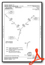
Standard Terminal Arrival (STAR) Charts

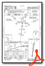
Instrument Approach Procedure (IAP) Charts


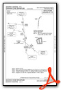
Departure Procedure (DP) Charts


Nearby Airports with Instrument Procedures
| ID | Name | Heading / Distance | ||
|---|---|---|---|---|
 |
8A4 | Indianapolis Downtown Heliport | 341° | 8.8 |
 |
KIND | Indianapolis International Airport | 299° | 11.0 |
|
KGEZ | Shelbyville Municipal Airport | 101° | 13.4 |
|
KEYE | Eagle Creek Airpark Airport | 321° | 15.5 |
|
KMQJ | Indianapolis Regional Airport | 034° | 15.6 |
|
KUMP | Indianapolis Metro Airport | 006° | 18.6 |
|
2R2 | Hendricks County-Gordon Graham Field Airport | 291° | 19.3 |
|
KBAK | Columbus Municipal Airport | 157° | 23.7 |
|
KTYQ | Indianapolis Exec Airport | 342° | 25.2 |
|
I34 | Greensburg Municipal Airport | 125° | 32.0 |
|
KGPC | Putnam County Regional Airport | 270° | 33.6 |
|
5I4 | Sheridan Airport | 349° | 33.5 |
Fuel Providers

Airport Images
Do you have a recent image of this airport? Upload it here!


