Login
Register


UMP
Indianapolis Metro Airport
Official FAA Data Effective 2026-01-22 0901Z
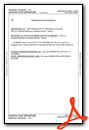
Chart Supplement

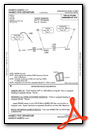
KUMP Airport Diagram

VFR Chart of KUMP
Sectional Charts at SkyVector.com
IFR Chart of KUMP
Enroute Charts at SkyVector.com
Location Information for KUMP
Coordinates: N39°56.12' / W86°2.70'Located 08 miles NE of Indianapolis, Indiana on 445 acres of land. View all Airports in Indiana.
Surveyed Elevation is 811 feet MSL.
Operations Data
|
|
Airport Communications
| AWOS-3PT: | 119.375 Tel. 317-842-3911 |
|---|---|
| INDIANAPOLIS APPROACH: | 127.15 317.8 |
| INDIANAPOLIS DEPARTURE: | 127.15 317.8 |
| CLEARANCE DELIVERY: | 121.625 |
| RACYR STAR: | 128.175 317.8 |
| UNICOM: | 123.000 |
| CTAF: | 123.000 |
| AWOS-3PT at MQJ (9.0 SE): | 124.175 317-335-3037 |
| AWOS-3 at 22L (10.3 SW): | 127.075 317-964-9799 |
| AWOS-3PT at TYQ (11.1 NW): | 120.725 317-769-3154 |
Nearby Navigation Aids
|
| ||||||||||||||||||||||||||||||||||||||||||||||||||||||||||||


Runway 15/33
| Dimensions: | 4004 x 100 feet / 1220 x 30 meters | |
|---|---|---|
| Surface: | Asphalt / Grooved in Good Condition | |
| Weight Limits: | 17 /F/C/X/T, S-17 | |
| Edge Lighting: | Medium Intensity | |
| Runway 15 | Runway 33 | |
| Coordinates: | N39°56.40' / W86°2.95' | N39°55.85' / W86°2.46' |
| Elevation: | 787.1 | 811.2 |
| Traffic Pattern: | Left | Left |
| Runway Heading: | 146° True | 326° True |
| Displaced Threshold: | 156 Feet | |
| Markings: | Non-Precision Instrument in good condition. | Non-Precision Instrument in good condition. |
| Glide Slope Indicator | P4L (3.00° Glide Path Angle) | P4L (3.50° Glide Path Angle) |
| REIL: | Yes | Yes |
| Obstacles: | 11 ft Road 275 ft from runway, 260 ft right of center APCH SLOPE 21:1 AT DSPLCD THR; 37 FT TREES 800 FT FM DSPLCD THR 260 FT LEFT. |
|
Services Available
| Fuel: | 100LL (blue), Jet-A |
|---|---|
| Transient Storage: | Hangars,Tiedowns |
| Airframe Repair: | MAJOR |
| Engine Repair: | MAJOR |
| Bottled Oxygen: | HIGH |
| Bulk Oxygen: | NONE |
| Other Services: | AIR AMBULANCE SERVICES,CHARTER SERVICE,PILOT INSTRUCTION,AIRCRAFT RENTAL,AIRCRAFT SALES |
Ownership Information
| Ownership: | Publicly owned | |
|---|---|---|
| Owner: | INDIANAPOLIS ARPT AUTH | |
| 7800 COL. H. WEIR COOK MEM. DRIVE, SUITE 100 | ||
| INDIANAPOLIS, IN 46241-4941 | ||
| (317) 487-7243 | ||
| Manager: | KEITH BERLEN | |
| 7800 COL H. WEIR COOK MEM. DRIVE, SUITE 100 | ||
| INDIANAPOLIS, IN 46241-4941 | ||
| (317) 487-7243 | ||
Other Remarks
- OUTSIDE PHONE AVBL.
- ACFT TAKEOFF/LANDING FM RY 15 DURING CALM WIND/CROSSWIND CONDITIONS; DURING ANY QUESTIONABLE PERIOD RY 15 SHALL BE PREFERRED RY - CALL AMGR 317-487-9594.
- FBO PHONE NUMBER - 317-849-0840
- 500 FT AGL MOORED HOT AIR BALLOON LCTD APRXLY 4.4 MILES NORTH-NORTHWEST OF ARPT. BALLOON WILL OPER DLY FROM 1300-2200Z++ AND IS INTERNALLY ILLUMINATED.
- ACTVT REIL RWY 15 AND 33, MIRL RWY 15/33 - CTAF.
Weather Minimums


Standard Terminal Arrival (STAR) Charts

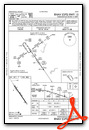
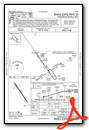
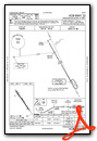
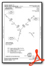
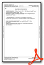
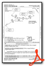
Instrument Approach Procedure (IAP) Charts
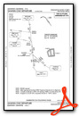
Departure Procedure (DP) Charts

Nearby Airports with Instrument Procedures
| ID | Name | Heading / Distance | ||
|---|---|---|---|---|
 |
KMQJ | Indianapolis Regional Airport | 129° | 8.8 |
|
KTYQ | Indianapolis Exec Airport | 300° | 11.0 |
|
KEYE | Eagle Creek Airpark Airport | 241° | 13.1 |
|
5I4 | Sheridan Airport | 331° | 16.6 |
|
KIND | Indianapolis International Airport | 221° | 17.4 |
|
KHFY | Indy South Greenwood Airport | 186° | 18.6 |
|
KAID | Anderson Regional Airport | 062° | 22.5 |
|
2R2 | Hendricks County-Gordon Graham Field Airport | 240° | 22.9 |
|
KGEZ | Shelbyville Municipal Airport | 152° | 23.9 |
|
KFKR | Frankfort Clinton County Regional Airport | 310° | 31.3 |
|
KUWL | New Castle Henry County Marlatt Field Airport | 095° | 33.4 |
|
KMIE | Delaware County Regional Airport | 058° | 35.1 |


Comments
Indy Metro is a nice airport
Indy Metro is a nice airport with lots of tie down spots, fast fast service, but I believe limited access hours. I stopped here for overnight and rented a car by calling the day ahead, sixt; excellent experience. Thanks Wes. On the way out the fuel service was fast and friendly. Even the guy in the Cirrus gave way to me as I was taxing into the ramp. If you are going to Indianapolis stay here.
Pages