Login
Register


74V
Roosevelt Municipal Airport
Official FAA Data Effective 2026-01-22 0901Z
Chart Supplement

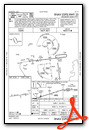
VFR Chart of 74V
Sectional Charts at SkyVector.com
IFR Chart of 74V
Enroute Charts at SkyVector.com
Location Information for 74V
Coordinates: N40°16.70' / W110°3.08'Located 03 miles SW of Roosevelt, Utah on 208 acres of land. View all Airports in Utah.
Surveyed Elevation is 5176 feet MSL.
Operations Data
|
|
Airport Communications
| AWOS-3P: | 118.975 Tel. 435-722-4201 |
|---|---|
| CTAF: | 122.800 |
| UNICOM: | 122.800 |
| AWOS-3 at U69 (16.1 W): | 121.125 435-738-0353 |
| ASOS at VEL (26.5 E): | 118.125 435-781-1224 |
| AWOS-3PT at 40U (45.9 N): | 119.250 435-784-3123 |
- COMMUNICATIONS PRVDD BY CEDAR CITY RADIO ON FREQS 122.1R/112.7T (MYTON RCO).
- APCH/DEP CTL SVC PRVDD BY SALT LAKE ARTCC (ZLC) ON 135.775/257.7 (FAIRFIELD RCAG).
Nearby Navigation Aids
|
| ||||||||||||||||||||||||||||||||||||

Runway 07/25
| Dimensions: | 6501 x 75 feet / 1982 x 23 meters | |
|---|---|---|
| Surface: | Asphalt in Excellent Condition | |
| Weight Limits: | 15 /F/C/X/T, S-30, D-60 | |
| Edge Lighting: | Medium Intensity | |
| Runway 07 | Runway 25 | |
| Coordinates: | N40°16.64' / W110°3.78' | N40°16.77' / W110°2.39' |
| Elevation: | 5176.1 | 5110.1 |
| Traffic Pattern: | Left | Left |
| Runway Heading: | 83° True | 263° True |
| Markings: | Non-Precision Instrument in good condition. | Non-Precision Instrument in good condition. |
| Glide Slope Indicator | P4L (3.00° Glide Path Angle) | P4L (3.00° Glide Path Angle) |
| REIL: | Yes | Yes |
Services Available
| Fuel: | 100LL (blue), Jet-A |
|---|---|
| Transient Storage: | Hangars,Tiedowns |
| Airframe Repair: | MAJOR |
| Engine Repair: | MAJOR |
| Bottled Oxygen: | NOT AVAILABLE |
| Bulk Oxygen: | NOT AVAILABLE |
| Other Services: | PILOT INSTRUCTION,AIRCRAFT RENTAL |
Ownership Information
| Ownership: | Publicly owned | |
|---|---|---|
| Owner: | CITY OF ROOSEVELT | |
| 255 S. STATE ST. | ||
| ROOSEVELT, UT 84066 | ||
| 435-722-5001 | ||
| Manager: | KIRBY WOLFINJER | PUBLIC WORKS DIR/ARPT MGR. |
| 255 S. STATE ST. | ||
| ROOSEVELT, UT 84066 | ||
| 435-722-5001 | ||
Other Remarks
- ACTVT & INCR INTST REIL RWY 07 & 25; MIRL RWY 7/25 - CTAF. PAPI RWY 07 & 25 ON CONSLY.
Weather Minimums
Instrument Approach Procedure (IAP) Charts
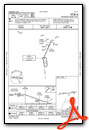
Nearby Airports with Instrument Procedures
| ID | Name | Heading / Distance | ||
|---|---|---|---|---|
 |
KVEL | Vernal Regional Airport | 068° | 26.5 |
|
KPUC | Carbon County Regional/Buck Davis Field Airport | 219° | 51.3 |
|
4V0 | Rangely Airport | 100° | 60.3 |
|
KHCR | Heber Valley Airport | 281° | 64.3 |
|
69V | Huntington Municipal Airport | 216° | 68.0 |
|
KFBR | Fort Bridger Airport | 346° | 68.8 |
|
KSPK | Spanish Fork Municipal/Woodhouse Field Airport | 264° | 74.7 |
|
KEVW | Evanston-Uinta County Burns Field Airport | 323° | 74.7 |
|
KPVU | Provo Municipal Airport | 267° | 76.9 |
|
U34 | Green River Municipal Airport | 185° | 79.4 |
|
U14 | Nephi Municipal Airport | 249° | 89.9 |
|
KRKS | Southwest Wyoming Regional Airport | 029° | 90.8 |
Airport Images
Do you have a recent image of this airport? Upload it here!


