Login
Register


7G8
Geauga County Airport
Official FAA Data Effective 2025-11-27 0901Z
Chart Supplement

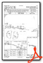
VFR Chart of 7G8
Sectional Charts at SkyVector.com
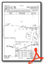
IFR Chart of 7G8
Enroute Charts at SkyVector.com
Location Information for 7G8
Coordinates: N41°26.98' / W81°3.78'Located 01 miles SE of Middlefield, Ohio on 51 acres of land. View all Airports in Ohio.
Surveyed Elevation is 1174 feet MSL.
Operations Data
|
|
Airport Communications
| CLEVELAND APPROACH: | 125.35 346.325 |
|---|---|
| CLEVELAND DEPARTURE: | 125.35 346.325 |
| UNICOM: | 123.000 |
| CTAF: | 123.000 |
| AWOS-3 at POV (16.7 SW): | 118.675 330-298-9353 |
| AWOS-3PT at CGF (20.3 W): | 216-998-7640 |
| D-ATIS at CGF (20.3 W): | 119.95 |
Nearby Navigation Aids
|
| ||||||||||||||||||||||||||||||||||||||||||||||||||||||||||||


Runway 11/29
| Dimensions: | 3500 x 65 feet / 1067 x 20 meters | |
|---|---|---|
| Surface: | Asphalt in Good Condition | |
| Weight Limits: | S-18 | |
| Edge Lighting: | Medium Intensity | |
| Runway 11 | Runway 29 | |
| Coordinates: | N41°27.03' / W81°4.15' | N41°26.93' / W81°3.40' |
| Elevation: | 1174.3 | 1157.9 |
| Traffic Pattern: | Left | Left |
| Runway Heading: | 100° True | 280° True |
| Displaced Threshold: | 179 Feet | |
| Markings: | Non-Precision Instrument in good condition. | Non-Precision Instrument in good condition. |
| Glide Slope Indicator | P2L (3.00° Glide Path Angle) | |
| REIL: | Yes | Yes |
| Obstacles: | 45 ft Antenna 551 ft from runway, 160 ft right of center APCH RATIO 16:1 TO DTHR. +3-6 FT BRUSH, 0-140 FT DIST, 220 FT L. |
|
Services Available
| Fuel: | 100LL (blue), Automotive Gasoline |
|---|---|
| Transient Storage: | Hangars,Tiedowns SUBJ AVBLTY. |
| Airframe Repair: | NONE |
| Engine Repair: | NONE |
| Bottled Oxygen: | NONE |
| Bulk Oxygen: | NONE |
| Other Services: | AIR AMBULANCE SERVICES,GLIDER SERVICE,GLIDER TOWING SERVICES |
Ownership Information
| Ownership: | Publicly owned | |
|---|---|---|
| Owner: | GEAUGA CO BOARD OF COMM | |
| COURTHOUSE ANNEX, 231 MAIN ST | ||
| CHARDON, OH 44024-1263 | ||
| 440-285-2222 | ||
| Manager: | RICHARD BLAMER | 7G8MANAGER@GMAIL.COM. |
| PO BOX 1308 | ||
| MIDDLEFIELD, OH 44062-1308 | ||
| 440-632-1884 | CELL 216-509-8858. | |
Other Remarks
- PARL TWY EAST OF TEE HNGRS CLSD PERMLY.
- EXTSV GLDR ACT ON & INVOF ARPT.
- DEER, BIRDS, & OTR WILDLIFE ON & INVOF ARPT.
- FOR CD CTC CLEVELAND APCH AT 216-352-2323.
- ADZY ONLY WX AVBL - 4 CLICKS CTAF.
- 0LL 100LL AVBL H24 VIA CREDIT CARD.
- ROPES NOT PRVDD.
- ACTVT REIL RWY 11 & 29; PAPI RWY 29; MIRL RWY 11/29 - CTAF.
Weather Minimums

Instrument Approach Procedure (IAP) Charts
Nearby Airports with Instrument Procedures
| ID | Name | Heading / Distance | ||
|---|---|---|---|---|
 |
2G1 | Concord Airpark Airport | 335° | 14.4 |
|
KPOV | Portage County Airport | 210° | 16.7 |
|
KCGF | Cuyahoga County Airport | 289° | 20.3 |
|
KLNN | Lake County Exec Airport | 313° | 20.4 |
|
KYNG | Youngstown/Warren Regional Airport | 122° | 20.6 |
|
1G3 | Kent State University Airport | 221° | 23.9 |
|
KHZY | Northeast Ohio Regional Airport | 039° | 25.7 |
|
KBKL | Burke Lakefront Airport | 278° | 28.2 |
|
4G1 | Greenville Municipal Airport | 090° | 30.3 |
|
KAKR | Akron Fulton International Airport | 216° | 30.8 |
|
38D | Salem Airpark Airport | 163° | 31.4 |
|
3G6 | Tri-City Airport | 174° | 32.7 |
Airport Images

By: btracy62


