Login
Register


LNN
Lake County Exec Airport
Official FAA Data Effective 2026-02-19 0901Z
Chart Supplement

VFR Chart of KLNN
Sectional Charts at SkyVector.com
IFR Chart of KLNN
Enroute Charts at SkyVector.com
Location Information for KLNN
Coordinates: N41°41.04' / W81°23.39'Located 03 miles N of Willoughby, Ohio on 400 acres of land. View all Airports in Ohio.
Surveyed Elevation is 625 feet MSL.
Operations Data
|
|
Airport Communications
| AWOS-3PT: | 119.225 Tel. 440-942-0809 |
|---|---|
| CLEVELAND APPROACH: | 125.35 346.325 |
| CLEVELAND DEPARTURE: | 125.35 346.325 |
| ROLLN STAR: | 126.55 |
| TRYBE STAR: | 126.55 |
| BRWNZ STAR: | 126.55 |
| UNICOM: | 122.725 |
| ROKNN STAR: | 126.55 |
| CTAF: | 122.725 |
| D-ATIS at CGF (8.4 SW): | 119.95 |
| AWOS-3PT at CGF (8.5 SW): | 216-998-7640 |
| ATIS at BKL (16.5 SW): | 125.25 |
Nearby Navigation Aids
|
| ||||||||||||||||||||||||||||||||||||||||||||||||||||||||||||


Runway 05/23
| Dimensions: | 5028 x 100 feet / 1533 x 30 meters | |
|---|---|---|
| Surface: | Asphalt in Fair Condition | |
| Weight Limits: | S-68, D-80, ST-124 | |
| Edge Lighting: | Medium Intensity | |
| Runway 05 | Runway 23 | |
| Coordinates: | N41°40.83' / W81°23.85' | N41°41.41' / W81°23.07' |
| Elevation: | 623.7 | 619.5 |
| Traffic Pattern: | Left | Left |
| Runway Heading: | 45° True | 225° True |
| Displaced Threshold: | 428 Feet | |
| Markings: | Non-Precision Instrument in good condition. | Non-Precision Instrument in good condition. |
| Glide Slope Indicator | P4L (3.50° Glide Path Angle) | P4L (4.00° Glide Path Angle) |
| REIL: | Yes | Yes |
| Obstacles: | 62 ft Tree 1399 ft from runway, 157 ft left of center APCH SLP 24:1 TO DTHR OVR +98 FT TREE, 2372 FT DIST, 548 FT L. |
98 ft Trees 1335 ft from runway, 341 ft right of center |
Runway 10/28
| Dimensions: | 4272 x 100 feet / 1302 x 30 meters | |
|---|---|---|
| Surface: | Asphalt in Fair Condition | |
| Weight Limits: | S-68, D-80, ST-124 | |
| Edge Lighting: | Medium Intensity | |
| Runway 10 | Runway 28 | |
| Coordinates: | N41°40.95' / W81°23.77' | N41°40.94' / W81°22.83' |
| Elevation: | 623.6 | 624.1 |
| Traffic Pattern: | Left | Left |
| Runway Heading: | 91° True | 271° True |
| Displaced Threshold: | 1124 Feet | |
| Markings: | Non-Precision Instrument in good condition. | Non-Precision Instrument in good condition. |
| Glide Slope Indicator | P2L (3.50° Glide Path Angle) | P2L (3.50° Glide Path Angle) |
| REIL: | Yes | Yes |
| Obstacles: | 68 ft Trees 738 ft from runway, 215 ft left of center APCH SLP 10:1 TO DTHR OVR +89 FT TREES, 931 FT DIST, 329 FT L. |
|
Services Available
| Fuel: | 100LL (blue), Jet-A |
|---|---|
| Transient Storage: | Hangars,Tiedowns |
| Airframe Repair: | MAJOR |
| Engine Repair: | MAJOR |
| Bottled Oxygen: | NONE |
| Bulk Oxygen: | HIGH/LOW |
| Other Services: | CHARTER SERVICE,PILOT INSTRUCTION,AIRCRAFT RENTAL |
Ownership Information
| Ownership: | Publicly owned | |
|---|---|---|
| Owner: | LAKE DEVELOPMENT AUTHORITY | |
| 105 MAIN ST STE B-501 | ||
| PAINESVILLE, OH 44077-3414 | ||
| 440-350-5342 | ||
| Manager: | PATRICK T MOHORCIC | |
| 105 MAIN ST STE B-501 | ARPT PHYS ADS: 38550 JET CENTER DR, WILLOUGHBY, OH 44094-8174. | |
| PAINESVILLE, OH 44077-3414 | ||
| 440-350-5343 | CELL 440-321-9036. | |
Other Remarks
- DEER, BIRDS, & OTR WILDLIFE ON & INVOF ARPT.
- PAT WORK NA 2300-0800.
- FOR CD CTC CLEVELAND APCH AT 216-352-2323.
- ACTVT REIL RWY 05, 23, 10, & 28; MIRL RWY 05/23 & 10/28 - CTAF. PAPI RWY 05, 23, 10, & 28 OPR CONSLY.
Weather Minimums

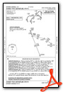
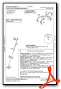
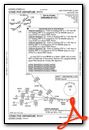
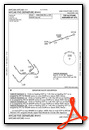
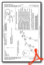
Standard Terminal Arrival (STAR) Charts

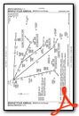


Instrument Approach Procedure (IAP) Charts

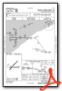
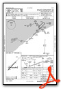
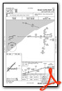
Departure Procedure (DP) Charts
Nearby Airports with Instrument Procedures
| ID | Name | Heading / Distance | ||
|---|---|---|---|---|
 |
KCGF | Cuyahoga County Airport | 211° | 8.4 |
|
2G1 | Concord Airpark Airport | 096° | 8.7 |
|
KBKL | Burke Lakefront Airport | 233° | 16.5 |
|
7G8 | Geauga County Airport | 133° | 20.4 |
|
KCLE | Cleveland-Hopkins International Airport | 231° | 26.6 |
|
KPOV | Portage County Airport | 167° | 29.1 |
|
KHZY | Northeast Ohio Regional Airport | 079° | 31.6 |
|
1G3 | Kent State University Airport | 182° | 32.0 |
|
1G5 | Medina Municipal Airport | 207° | 37.2 |
|
1G1 | Elyria Airport | 236° | 38.4 |
|
KAKR | Akron Fulton International Airport | 185° | 38.9 |
|
KYNG | Youngstown/Warren Regional Airport | 128° | 40.8 |
Airport Images
Do you have a recent image of this airport? Upload it here!


