Login
Register


8N2
Skydive Chicago Airport
Official FAA Data Effective 2025-12-25 0901Z
Chart Supplement

VFR Chart of 8N2
Sectional Charts at SkyVector.com
IFR Chart of 8N2
Enroute Charts at SkyVector.com
Location Information for 8N2
Coordinates: N41°23.99' / W88°47.64'Located 04 miles NE of Ottawa, Illinois on 240 acres of land. View all Airports in Illinois.
Estimated Elevation is 616 feet MSL.
Operations Data
|
|
Airport Communications
| CTAF: | 122.725 |
|---|---|
| UNICOM: | 122.725 |
| AWOS-3 at VYS (16.5 W): | 120.025 815-223-8442 |
| AWOS-3 at C09 (17.0 E): | 118.175 815-941-1815 |
| ASOS at ARR (26.5 NE): | 630-466-5649 |
Nearby Navigation Aids
|
| ||||||||||||||||||||||||||||||||||||||||||||||||||||||||||||


Runway 03/21
| Dimensions: | 4522 x 50 feet / 1378 x 15 meters | |
|---|---|---|
| Surface: | Asphalt in Good Condition | |
| Weight Limits: | S-12 | |
| Edge Lighting: | Low Intensity | |
| Runway 03 | Runway 21 | |
| Coordinates: | N41°23.67' / W88°47.90' | N41°24.30' / W88°47.37' |
| Elevation: | 615.5 | 611.3 |
| Traffic Pattern: | Right | |
| Runway Heading: | 33° True | 213° True |
| Markings: | Basic in good condition. | Basic in good condition. |
Services Available
| Fuel: | NONE |
|---|---|
| Transient Storage: | Hangars,Tiedowns |
| Airframe Repair: | NOT AVAILABLE |
| Engine Repair: | NOT AVAILABLE |
| Bottled Oxygen: | NOT AVAILABLE |
| Bulk Oxygen: | NOT AVAILABLE |
Ownership Information
| Ownership: | Privately Owned | |
|---|---|---|
| Owner: | OTTAWA AIRPORT INC | |
| 3215 E. 1969TH RD | ||
| OTTAWA, IL 61350 | ||
| 815-433-0000 | ||
| Manager: | ROOK NELSON | |
| 3215 E. 1969TH RD | EMAIL ADDRESS: ROOK@SKYDIVECHICAGO.COM (ALL LOWER CASE) | |
| OTTAWA, IL 61350 | ||
| 815-433-0000 | ||
Other Remarks
- THIS AIRPORT HAS BEEN SURVEYED BY THE NATIONAL GEODETIC SURVEY.
- 268 FT CELLULAR TOWER 1/2 MI WSW OF RY 03.
- FOR NOISE ABATEMENT FLY WIDE PATTERN RY 03.
- EXTENSIVE PARACHUTE ACTVTY ON & INVOF ARPT.
- FOR CD CTC CHICAGO ARTCC AT 630-906-8921.
- ACTVT LIRL RY 03/21 - 122.725
Nearby Airports with Instrument Procedures
| ID | Name | Heading / Distance | ||
|---|---|---|---|---|
 |
KVYS | Illinois Valley Regional-Walter A Duncan Field Airport | 259° | 16.5 |
|
C09 | Morris Municipal/James R Washburn Field Airport | 084° | 17.0 |
|
KARR | Aurora Municipal Airport | 032° | 26.5 |
|
KPNT | Pontiac Municipal Airport | 164° | 29.5 |
|
KRPJ | Rochelle Municipal/Koritz Field Airport | 336° | 32.2 |
|
KDKB | De Kalb Taylor Municipal Airport | 007° | 32.3 |
|
KLOT | Lewis University Airport | 068° | 33.8 |
|
1C5 | Bolingbrook's Clow International Airport | 059° | 34.8 |
|
C75 | Marshall County Airport | 229° | 35.2 |
|
KDPA | Dupage Airport | 038° | 39.1 |
|
C73 | Dixon Municipal-Charles R Walgreen Field Airport | 311° | 39.2 |
|
KSQI | Whiteside County/Jos H Bittorf Field Airport | 297° | 44.7 |
Airport Images
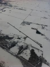
By: TomFrymark


