Login
Register
8PA0
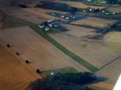
Numidia Airport
Official FAA Data Effective 2026-10-01 0901Z
VFR Chart of 8PA0
Sectional Charts at SkyVector.com
IFR Chart of 8PA0
Enroute Charts at SkyVector.com
Location Information for 8PA0
Coordinates: N40°51.97' / W76°23.85'Located 01 miles S of Numidia, Pennsylvania on 5 acres of land. View all Airports in Pennsylvania.
Estimated Elevation is 1070 feet MSL.
Operations Data
|
|
Airport Communications
| AWOS-3 at N79 (7.3 W): | 119.175 570-672-0389 |
|---|---|
| AWOS-3 at ZER (9.6 S): | 127.575 570-544-2778 |
| AWOS-3 at 79PN (11.3 NW): | 118.075 570-271-8192 |
Nearby Navigation Aids
|
| ||||||||||||||||||||||||||||||||||||||||||||||||


Runway 08/26
| Dimensions: | 2000 x 100 feet / 610 x 30 meters | |
|---|---|---|
| Surface: | Turf | |
| Runway 08 | Runway 26 | |
| Displaced Threshold: | 200 Feet | |
| Obstacles: | 14 ft Road 144 ft from runway | |
Ownership Information
| Ownership: | Privately Owned | |
|---|---|---|
| Owner: | JIM BEAVER | |
| 251 AIRPORT ROAD | ||
| CATAWISSA, PA 17820 | ||
| 570-799-0388 | ||
| Manager: | JIM BEAVER | OTR: JAMES BEAVER NBIPRODUCTS@NUMIDIAAIRPORT.COM |
| 251 AIRPORT ROAD | ||
| CATAWISSA, PA 17820 | ||
| 570-799-0388 | ||
Other Remarks
- FOR CD CTC WILKES-BARRE APCH AT 570-655-2084.
Nearby Airports with Instrument Procedures
| ID | Name | Heading / Distance | ||
|---|---|---|---|---|
 |
N79 | Northumberland County Airport | 256° | 7.3 |
|
N13 | Bloomsburg Municipal Airport | 347° | 8.1 |
|
KZER | Schuylkill County/Joe Zerbey Airport | 173° | 9.6 |
|
8N8 | Danville Airport | 293° | 12.2 |
|
KHZL | Hazleton Regional Airport | 068° | 19.7 |
|
74N | Bendigo Airport | 201° | 19.9 |
|
KSEG | Penn Valley Airport | 262° | 21.4 |
|
22N | Jake Arner Memorial Airport | 096° | 29.2 |
|
9D4 | Deck Airport | 174° | 31.0 |
|
KIPT | Williamsport Regional Airport | 313° | 32.8 |
|
08N | Keller Brothers Airport | 174° | 34.6 |
|
KRDG | Reading Regional/Carl A Spaatz Field Airport | 145° | 35.3 |