Login
Register


98D
Onida Municipal Airport
Official FAA Data Effective 2026-01-22 0901Z
Chart Supplement

VFR Chart of 98D
Sectional Charts at SkyVector.com
IFR Chart of 98D
Enroute Charts at SkyVector.com
Location Information for 98D
Coordinates: N44°42.03' / W100°6.09'Located 02 miles W of Onida, South Dakota on 85 acres of land. View all Airports in South Dakota.
Surveyed Elevation is 1884 feet MSL.
Operations Data
|
|
Airport Communications
| AWOS-3P: | 120.0 |
|---|---|
| AWOS-2: | 122.9 Tel. 617-262-3825 |
| CTAF: | 122.900 |
| AWOS-3P at 0D8 (18.2 N): | 119.275 605-765-0132 |
| ASOS at PIR (20.7 SW): | 119.025 605-224-6087 |
| ASOS at MBG (52.4 N): | 121.425 605-206-3018 |
- APCH/DEP SVC PRVDD BY MINNEAPOLIS ARTCC ON FREQS 125.1/269.1 (PIERRE RCAG).
Nearby Navigation Aids
|
| ||||||||||||||||||||||||||||||||||||||||||||||||


Runway 13/31
| Dimensions: | 3800 x 60 feet / 1158 x 18 meters | |
|---|---|---|
| Surface: | Asphalt in Excellent Condition | |
| Edge Lighting: | Medium Intensity | |
| Runway 13 | Runway 31 | |
| Coordinates: | N44°42.28' / W100°6.32' | N44°41.81' / W100°5.75' |
| Elevation: | 1861.4 | 1884.8 |
| Traffic Pattern: | Left | Left |
| Runway Heading: | 139° True | 319° True |
| Markings: | Non-Precision Instrument in good condition. | Non-Precision Instrument in good condition. |
| Glide Slope Indicator | P2L (3.00° Glide Path Angle) | P2L (3.00° Glide Path Angle) |
Runway 08/26
RWY 08/26 CLSD WINTER MONTHS DUE TO LACK OF SNOW REMOVAL. | ||
| Dimensions: | 2160 x 120 feet / 658 x 37 meters | |
|---|---|---|
| Surface: | Turf in Good Condition | |
| Weight Limits: | S-125 | |
| Runway 08 | Runway 26 | |
| Coordinates: | N44°42.00' / W100°6.43' | N44°42.00' / W100°5.93' |
| Elevation: | 1882.8 | 1875.8 |
| Traffic Pattern: | Left | Left |
| Runway Heading: | 91° True | 271° True |
Services Available
| Fuel: | 100LL (blue), Jet-A |
|---|---|
| Transient Storage: | Hangars,Tiedowns |
| Airframe Repair: | MINOR |
| Engine Repair: | MINOR |
| Bottled Oxygen: | NONE |
| Bulk Oxygen: | NONE |
| Other Services: | CROP DUSTING SERVICES |
Ownership Information
| Ownership: | Publicly owned | |
|---|---|---|
| Owner: | CITY OF ONIDA | |
| PO BOX 72 | ||
| ONIDA, SD 57564 | ||
| 605-258-2441 | ||
| Manager: | TERRY BARBER | |
| PO BOX 131 | ||
| ONIDA, SD 57564 | ||
| 605-258-2743 | ||
Other Remarks
- 150 FT WATER TWR 1.4 MILE SE OF RWY 31.
- ULTRA-LIGHT ACT ARND ARPT.
- WILDLIFE ON AND INVOF ARPT.
- FOR CD CTC MINNEAPOLIS ARTCC AT 651-463-5588.
- RWY MKD WITH WHITE & BLACK CONES.
- RWY MKD WITH WHITE & BLACK CONES.
- ACTVT MIRL RWY 13/31 & PAPI RWY 13 & 31 - CTAF.
Weather Minimums

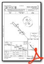
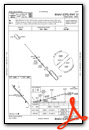
Instrument Approach Procedure (IAP) Charts
Nearby Airports with Instrument Procedures
| ID | Name | Heading / Distance | ||
|---|---|---|---|---|
 |
0D8 | Gettysburg Municipal Airport | 020° | 18.3 |
|
KPIR | Pierre Regional Airport | 202° | 20.6 |
|
9D0 | Highmore Municipal Airport | 108° | 29.5 |
|
KMKA | Miller Municipal Airport | 101° | 50.1 |
|
84D | Cheyenne Eagle Butte Airport | 289° | 51.9 |
|
KMBG | Mobridge Municipal Airport | 345° | 52.4 |
|
9V9 | Chamberlain Municipal Airport | 148° | 65.4 |
|
1D8 | Redfield Municipal Airport | 081° | 67.8 |
|
KPHP | Philip Airport | 239° | 75.4 |
|
4X4 | Wessington Springs Airport | 119° | 77.6 |
|
KICR | Winner Regional Airport | 171° | 79.5 |
|
KHON | Huron Regional Airport | 102° | 82.6 |
Airport Images
Do you have a recent image of this airport? Upload it here!


