Login
Register


4X4
Wessington Springs Airport
Official FAA Data Effective 2026-02-19 0901Z
Chart Supplement

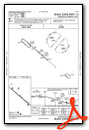
VFR Chart of 4X4
Sectional Charts at SkyVector.com
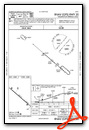
IFR Chart of 4X4
Enroute Charts at SkyVector.com
Location Information for 4X4
Coordinates: N44°3.71' / W98°31.93'Located 02 miles E of Wessington Springs, South Dakota on 270 acres of land. View all Airports in South Dakota.
Surveyed Elevation is 1544 feet MSL.
Operations Data
|
|
Airport Communications
| CTAF: | 122.900 |
|---|---|
| ASOS at HON (23.4 NE): | 118.125 605-215-0039 |
| ASOS at MHE (27.5 SE): | 124.175 605-995-5803 |
| AWOS-3P at 9V9 (38.5 SW): | 118.025 605-234-1437 |
- APCH/DEP SVC PRVDD BY MINNEAPOLIS ARTCC (ZMP) ON 126.25/339.8 (HURON RCAG).
Nearby Navigation Aids
|
| ||||||||||||||||||||||||||||||||||||||||||||||||||||||||||||


Runway 12/30
| Dimensions: | 3600 x 60 feet / 1097 x 18 meters | |
|---|---|---|
| Surface: | Asphalt in Excellent Condition | |
| Edge Lighting: | Medium Intensity | |
| Runway 12 | Runway 30 | |
| Coordinates: | N44°3.91' / W98°32.24' | N44°3.52' / W98°31.62' |
| Elevation: | 1544.4 | 1529.4 |
| Runway Heading: | 131° True | 311° True |
| Markings: | Non-Precision Instrument in good condition. | Non-Precision Instrument in good condition. |
| Glide Slope Indicator | P4L (3.00° Glide Path Angle) | P4L (3.00° Glide Path Angle) |
| REIL: | Yes | Yes |
| Obstacles: | 25 ft Power Line 832 ft from runway, 390 ft left of center | |
Services Available
| Fuel: | 100LL (blue) |
|---|---|
| Transient Storage: | Hangars,Tiedowns |
| Airframe Repair: | NOT AVAILABLE |
| Engine Repair: | NOT AVAILABLE |
| Bottled Oxygen: | NOT AVAILABLE |
| Bulk Oxygen: | NOT AVAILABLE |
| Other Services: | CROP DUSTING SERVICES |
Ownership Information
| Ownership: | Publicly owned | |
|---|---|---|
| Owner: | CITY OF WESSINGTON SPRINGS | |
| PO BOX 100 | ||
| WESSINGTON SPRINGS, SD 57382 | ||
| 605-539-1691 | ||
| Manager: | BRIAN BERGELEEN | |
| PO BOX 100 | ||
| WESSINGTON SPRINGS, SD 57382 | ||
| 605-539-1691 | COUNTY OFFICES # 605-539-1691. | |
Other Remarks
- FOR CD CTC MINNEAPOLIS ARTCC AT 651-463-5588.
- ACTVT MIRL RY 12/30; REIL & PAPI RYS 12 & 30 - CTAF.
- ROTG BCN - CTAF.
Weather Minimums

Instrument Approach Procedure (IAP) Charts
Nearby Airports with Instrument Procedures
| ID | Name | Heading / Distance | ||
|---|---|---|---|---|
 |
KHON | Huron Regional Airport | 033° | 23.4 |
|
KMHE | Mitchell Municipal Airport | 128° | 27.5 |
|
KMKA | Miller Municipal Airport | 326° | 33.3 |
|
9V9 | Chamberlain Municipal Airport | 242° | 38.5 |
|
8V3 | Parkston Municipal Airport | 149° | 47.4 |
|
6E5 | Wilder Airport | 061° | 47.5 |
|
9D0 | Highmore Municipal Airport | 306° | 48.9 |
|
KAGZ | Wagner Municipal Airport | 170° | 60.7 |
|
8D7 | Clark County Airport | 034° | 61.2 |
|
KMDS | Madison Municipal Airport | 091° | 62.7 |
|
9D1 | Gregory Municipal/Flynn Field Airport | 217° | 63.1 |
|
KICR | Winner Regional Airport | 235° | 69.8 |
Airport Images
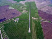
By: jcbecker@pie.mi...


