Login
Register


9V9
Chamberlain Municipal Airport
Official FAA Data Effective 2026-01-22 0901Z
Chart Supplement

VFR Chart of 9V9
Sectional Charts at SkyVector.com
IFR Chart of 9V9
Enroute Charts at SkyVector.com
Location Information for 9V9
Coordinates: N43°45.97' / W99°19.27'Located 03 miles S of Chamberlain, South Dakota on 329 acres of land. View all Airports in South Dakota.
Estimated Elevation is 1696 feet MSL.
Operations Data
|
|
Airport Communications
| AWOS-3P: | 118.025 Tel. 605-234-1437 |
|---|---|
| UNICOM: | 122.800 |
| CTAF: | 122.800 |
| ASOS at ICR (32.1 SW): | 126.775 605-842-3989 |
| ASOS at MHE (55.6 E): | 124.175 605-995-5803 |
| ASOS at PIR (55.7 NW): | 119.025 605-224-6087 |
- APCH/DEP SVC PRVDD BY MINNEAPOLIS ARTCC ON FREQS 125.1/269.1 (PIERRE RCAG).
Nearby Navigation Aids
|
| ||||||||||||||||||||||||||||||||||||||||||||||||||||||


Runway 13/31
| Dimensions: | 4299 x 75 feet / 1310 x 23 meters | |
|---|---|---|
| Surface: | Asphalt in Fair Condition | |
| Weight Limits: | S-12 | |
| Edge Lighting: | Medium Intensity | |
| Runway 13 | Runway 31 | |
| Coordinates: | N43°46.22' / W99°19.58' | N43°45.67' / W99°18.97' |
| Elevation: | 1696.3 | 1678.1 |
| Runway Heading: | 141° True | 321° True |
| Markings: | Non-Precision Instrument in good condition. | Non-Precision Instrument in good condition. |
| Glide Slope Indicator | P2L (3.00° Glide Path Angle) | P2L (3.00° Glide Path Angle) |
| Obstacles: | 64 ft Tree 1539 ft from runway, 415 ft left of center | |
Runway 18/36
| Dimensions: | 3403 x 150 feet / 1037 x 46 meters | |
|---|---|---|
| Surface: | Turf in Good Condition | |
| Runway 18 | Runway 36 | |
| Coordinates: | N43°46.28' / W99°19.22' | N43°45.72' / W99°19.32' |
| Elevation: | 1696.0 | 1680.0 |
| Runway Heading: | 187° True | 7° True |
| Obstacles: | 46 ft Pole 1000 ft from runway | |
Services Available
| Fuel: | 100LL (blue), Jet-A |
|---|---|
| Transient Storage: | Hangars,Tiedowns |
| Airframe Repair: | MINOR |
| Engine Repair: | MINOR |
| Bottled Oxygen: | NOT AVAILABLE |
| Bulk Oxygen: | NOT AVAILABLE |
| Other Services: | CROP DUSTING SERVICES |
Ownership Information
| Ownership: | Publicly owned | |
|---|---|---|
| Owner: | CITY OF CHAMBERLAIN | |
| 715 N. MAIN ST. | ||
| CHAMBERLAIN, SD 57325 | ||
| 605-680-9935 | ||
| Manager: | DUSTEN HRABE | |
| 101 AIRPORT ROAD | ||
| CHAMBERLAIN, SD 57325 | ||
| 605-680-9935 | ||
Other Remarks
- WATERFOWL ON & INVOF ARPT.
- GCO AVBL ON FREQ 121.725 ( 4 CLICKS TO MINNEAPOLIS CENTER AND 6 CLIKCS TO FLIGHT SERVICES)
- FOR CD IF UNA VIA GCO CTC MINNEAPOLIS ARTCC AT 651-463-5588.
- MKD WITH WHITE/BLACK TIPPED MKR CONES.
- MKD WITH WHITE/BLACK TIPPED MKR CONES.
- 0LL FUEL AVBL 24 HRS WITH CREDIT CARD.
- MIRL RY 13/31 PRESET ON LOW INTST, TO INCR INTST & ACTVT PAPI RYS 13 & 31 - CTAF.
Weather Minimums

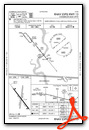
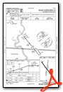
Instrument Approach Procedure (IAP) Charts
Nearby Airports with Instrument Procedures
| ID | Name | Heading / Distance | ||
|---|---|---|---|---|
 |
KICR | Winner Regional Airport | 225° | 32.0 |
|
9D1 | Gregory Municipal/Flynn Field Airport | 186° | 32.9 |
|
4X4 | Wessington Springs Airport | 062° | 38.5 |
|
9D0 | Highmore Municipal Airport | 353° | 46.8 |
|
KMKA | Miller Municipal Airport | 018° | 48.2 |
|
KMHE | Mitchell Municipal Airport | 089° | 55.8 |
|
KPIR | Pierre Regional Airport | 311° | 55.8 |
|
KHON | Huron Regional Airport | 051° | 60.1 |
|
KAGZ | Wagner Municipal Airport | 132° | 61.5 |
|
8V3 | Parkston Municipal Airport | 111° | 62.6 |
|
98D | Onida Municipal Airport | 329° | 65.4 |
|
KRBE | Rock County Airport | 188° | 72.5 |
Airport Images
Do you have a recent image of this airport? Upload it here!


