Login
Register


PIR
Pierre Regional Airport
Official FAA Data Effective 2026-02-19 0901Z
Chart Supplement

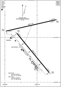
KPIR Airport Diagram
VFR Chart of KPIR
Sectional Charts at SkyVector.com
IFR Chart of KPIR
Enroute Charts at SkyVector.com
Location Information for KPIR
Coordinates: N44°22.96' / W100°17.16'Located 03 miles E of Pierre, South Dakota on 1834 acres of land. View all Airports in South Dakota.
Surveyed Elevation is 1744 feet MSL.
Operations Data
|
|
Airport Communications
| ASOS: | 119.025 Tel. 605-224-6087 |
|---|---|
| CTAF: | 122.700 |
| UNICOM: | 122.950 |
| AWOS-3P at 98D (20.7 NE): | 120.0 |
| AWOS-3P at 0D8 (38.9 N): | 119.275 605-765-0132 |
| AWOS-3P at 9V9 (55.7 SE): | 118.025 605-234-1437 |
- APCH/DEP SVC PRVDD BY MINNEAPOLIS ARTCC ON FREQS 125.1/269.1 (PIERRE RCAG).
Nearby Navigation Aids
|
| ||||||||||||||||||||||||||||||||||||||||||


Runway 13/31
| Dimensions: | 6900 x 100 feet / 2103 x 30 meters | |
|---|---|---|
| Surface: | Asphalt / Grooved in Good Condition | |
| Weight Limits: | S-91, D-108, ST-168
PCR VALUE: 421/F/D/W/T
| |
| Edge Lighting: | High Intensity | |
| Runway 13 | Runway 31 | |
| Coordinates: | N44°23.09' / W100°17.63' | N44°22.22' / W100°16.63' |
| Elevation: | 1730.8 | 1717.7 |
| Traffic Pattern: | Left | Left |
| Runway Heading: | 141° True | 321° True |
| Declared Distances: | TORA:6900 TODA:6900 ASDA:6900 LDA:6900 | TORA:6900 TODA:6900 ASDA:6900 LDA:6900 |
| Markings: | Precision Instrument in good condition. | Precision Instrument in good condition. |
| Glide Slope Indicator | P4L (3.00° Glide Path Angle) | P4L (3.00° Glide Path Angle) |
| Approach Lights: | MALSR 1,400 Foot Medium-intensity Approach Lighting System with runway alignment indicator lights. | |
| REIL: | Yes | |
Runway 07/25
| Dimensions: | 6880 x 100 feet / 2097 x 30 meters | |
|---|---|---|
| Surface: | Asphalt / Grooved in Good Condition | |
| Weight Limits: | S-91, D-114, ST-180
PCR VALUE: 515/F/D/X/T
| |
| Edge Lighting: | High Intensity | |
| Runway 07 | Runway 25 | |
| Coordinates: | N44°23.14' / W100°17.96' | N44°23.39' / W100°16.42' |
| Elevation: | 1744.1 | 1702.5 |
| Traffic Pattern: | Left | Left |
| Runway Heading: | 77° True | 257° True |
| Declared Distances: | TORA:6880 TODA:6880 ASDA:6880 LDA:6880 | TORA:6880 TODA:6880 ASDA:6880 LDA:6880 |
| Markings: | Non-Precision Instrument in good condition. | Non-Precision Instrument in good condition. |
| Glide Slope Indicator | P4L (3.00° Glide Path Angle) | P4L (3.00° Glide Path Angle) |
| REIL: | Yes | Yes |
| Obstacles: | 79 ft Tank 3158 ft from runway, 548 ft left of center | |
Services Available
| Fuel: | 100LL (blue), Jet-A |
|---|---|
| Transient Storage: | Hangars,Tiedowns |
| Airframe Repair: | MAJOR |
| Engine Repair: | MAJOR |
| Bottled Oxygen: | HIGH/LOW |
| Bulk Oxygen: | HIGH/LOW |
| Other Services: | AIR FREIGHT SERVICES,CROP DUSTING SERVICES,AIR AMBULANCE SERVICES,CHARTER SERVICE,PILOT INSTRUCTION,AIRCRAFT RENTAL,AIRCRAFT SALES |
Ownership Information
| Ownership: | Publicly owned | |
|---|---|---|
| Owner: | CITY OF PIERRE | |
| 3800 AIRPORT ROAD, SUITE 209 | ||
| PIERRE, SD 57501 | ||
| 605-773-7447 | ||
| Manager: | CASEY PAMPERIEN | |
| 3800 AIRPORT ROAD, SUITE 209 | ||
| PIERRE, SD 57501 | ||
| 605-773-7447 | ||
Other Remarks
- ARPT COND UNMON AT NGT FM LAST ACR ARR/DEP TILL 0500 LCL.
- CLASS I, ARFF INDEX B. ARFF COVERAGE PRVDD DURG SKED ACR OPS; 24 HRS PPR FOR UNSKED ACR OPS WITH MORE THAN 30 PSGR SEATS CALL ARPT OPS 605-773-7476/7405.
- TWY C IS 50 FT WIDE & RESTRD TO ACFT 75000 POUNDS OR LESS.
- NO LINE OF SIGHT BTN RWY ENDS OF RWY 07 & 25.
- BIRDS ON & INVOF ARPT AND WI 25 NM RADIUS.
- NOTE: SEE SPECIAL NOTICES SECTION & AEROBATIC PRACTICE AREAS.
- FOR CD IF UNA TO CTC ON FREQ, CTC MINNEAPOLIS ARTCC AT 651-463-5588.
- ATND DLY 1200-0400Z; FOR ATTENDANT OTR TIMES CALL 605-224-9000.
- NO
- ACTVT MALSR RWY 31; REIL RWY 07, 13, 25; PAPI RWY 07, 25, 13 & 31; HIRL RWY 07/25 & 13/31 -CTAF.
Weather Minimums


Instrument Approach Procedure (IAP) Charts


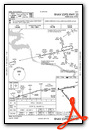
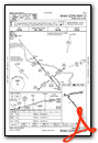
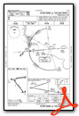

Nearby Airports with Instrument Procedures
| ID | Name | Heading / Distance | ||
|---|---|---|---|---|
 |
98D | Onida Municipal Airport | 022° | 20.6 |
|
9D0 | Highmore Municipal Airport | 074° | 37.1 |
|
0D8 | Gettysburg Municipal Airport | 021° | 38.9 |
|
84D | Cheyenne Eagle Butte Airport | 311° | 54.9 |
|
9V9 | Chamberlain Municipal Airport | 131° | 55.8 |
|
KMKA | Miller Municipal Airport | 081° | 57.7 |
|
KPHP | Philip Airport | 250° | 60.1 |
|
KICR | Winner Regional Airport | 161° | 62.6 |
|
KMBG | Mobridge Municipal Airport | 355° | 70.0 |
|
KSUO | Rosebud Sioux Tribal Airport | 200° | 71.9 |
|
4X4 | Wessington Springs Airport | 103° | 78.1 |
|
9D1 | Gregory Municipal/Flynn Field Airport | 150° | 79.5 |
Airport Images
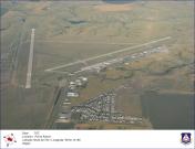
By: jcbecker@pie.mi...


