Login
Register


9KY9
Paintsville-Prestonsburg-Combs Field Airport
Official FAA Data Effective 2025-11-27 0901Z
VFR Chart of 9KY9
Sectional Charts at SkyVector.com
IFR Chart of 9KY9
Enroute Charts at SkyVector.com
Location Information for 9KY9
Coordinates: N37°44.73' / W82°46.66'Located 04 miles SE of Paintsville, Kentucky on 25 acres of land. View all Airports in Kentucky.
Estimated Elevation is 625 feet MSL.
Operations Data
|
|
Airport Communications
| UNICOM: | 122.800 |
|---|---|
| AWOS-3 at SJS (6.7 E): | 120.175 606-298-4143 |
| AWOS-3PT at PBX (14.9 SE): | 121.225 606-437-6701 |
| ASOS at JKL (27.2 W): | 118.375 606-252-3918 |
Nearby Navigation Aids
|
| ||||||||||||||||||||||||||||||||||||||||||||||||


Runway 13/31
| Dimensions: | 3239 x 75 feet / 987 x 23 meters | |
|---|---|---|
| Surface: | Asphalt in Good Condition | |
| Weight Limits: | S-25 | |
| Runway 13 | Runway 31 | |
| Coordinates: | N37°44.88' / W82°46.93' | N37°44.58' / W82°46.38' |
| Elevation: | 625.0 | 621.0 |
| Traffic Pattern: | Left | Left |
| Markings: | Basic in good condition. | Basic in good condition. |
| Obstacles: | 20 ft Trees 200 ft from runway, 60 ft left of center RY 13 HAS 300-500 FT HILLS 3000 FT FROM RY END. RY 13 20 FT TREES 150 FT FROM RY END & 60 FT LEFT. |
57 ft Trees 610 ft from runway, 84 ft left of center 12 FT TREES 150 FT FROM RY END & 45 FT LEFT. |
Services Available
| Fuel: | NONE |
|---|---|
| Transient Storage: | Hangars,Tiedowns |
| Airframe Repair: | NOT AVAILABLE |
| Engine Repair: | NOT AVAILABLE |
| Bottled Oxygen: | NONE |
| Bulk Oxygen: | NONE |
| Other Services: | PILOT INSTRUCTION,AIRCRAFT RENTAL |
Ownership Information
| Ownership: | Publicly owned | |
|---|---|---|
| Owner: | PAINTSVILLE-PRESTONBURG AIR BOARD | AIR BOARD CHAIRMAN LARRY SHORT |
| 8315 KY ROUTE 321 | ||
| HAGER HILL, KY 41222 | ||
| 606-434-3640 | ||
| Manager: | STANLEY HADDIX | |
| 8315 KY ROUTE 321 | ||
| HAGER HILL, KY 41222 | ||
| (606) 434-5335 | ||
Other Remarks
- ARPT LCTD IN MTN RIVER VALLEY. DFCLT APPROACHES TO RY.
- FOR CD CTC INDIANAPOLIS ARTCC AT 317-247-2411.
Nearby Airports with Instrument Procedures
| ID | Name | Heading / Distance | ||
|---|---|---|---|---|
 |
KSJS | Big Sandy Regional Airport | 087° | 6.7 |
|
KPBX | Pike County/Hatcher Field Airport | 137° | 14.9 |
|
KJKL | Julian Carroll Airport | 250° | 27.3 |
|
KEBD | Southern West Virginia Regional Airport | 096° | 31.4 |
|
KCPF | Wendell H Ford Airport | 227° | 31.5 |
|
KHTS | Tri-State/Milton J Ferguson Field Airport | 015° | 38.7 |
|
6L4 | Logan County Airport | 080° | 41.5 |
|
KLNP | Lonesome Pine Airport | 165° | 46.9 |
|
KSYM | Morehead-Rowan County Clyde A Thomas Regional Airport | 306° | 47.6 |
|
KDWU | Ashland Regional Airport | 002° | 48.5 |
|
12V | Ona Airpark Airport | 033° | 49.8 |
|
I16 | Kee Field Airport | 098° | 58.7 |
Airport Images
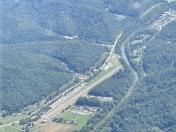
By: Big Orange Bird


