Login
Register


SJS
Big Sandy Regional Airport
Official FAA Data Effective 2025-12-25 0901Z
Chart Supplement

VFR Chart of KSJS
Sectional Charts at SkyVector.com
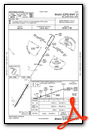
IFR Chart of KSJS
Enroute Charts at SkyVector.com
Location Information for KSJS
Coordinates: N37°45.06' / W82°38.20'Located 09 miles NE of Prestonsburg, Kentucky on 136 acres of land. View all Airports in Kentucky.
Surveyed Elevation is 1221 feet MSL.
Operations Data
|
|
Airport Communications
| AWOS-3: | 120.175 Tel. 606-298-4143 |
|---|---|
| HUNTINGTON APPROACH: | 119.75 270.1 |
| HUNTINGTON DEPARTURE: | 119.75 270.1 |
| CTAF: | 123.050 |
| UNICOM: | 123.050 |
| AWOS-3PT at PBX (11.8 S): | 121.225 606-437-6701 |
| ASOS at JKL (33.7 W): | 118.375 606-252-3918 |
| AWOS-3PT at 6L4 (34.8 E): | 119.375 304-752-0814 |
Nearby Navigation Aids
|
| ||||||||||||||||||||||||||||||||||||||||||


Runway 03/21
| Dimensions: | 5051 x 100 feet / 1540 x 30 meters | |
|---|---|---|
| Surface: | Asphalt in Excellent Condition | |
| Weight Limits: | 7 /F/D/X/T, S-19 | |
| Edge Lighting: | Medium Intensity | |
| Runway 03 | Runway 21 | |
| Coordinates: | N37°44.70' / W82°38.47' | N37°45.41' / W82°37.93' |
| Elevation: | 1169.6 | 1221.0 |
| Runway Heading: | 31° True | 211° True |
| Displaced Threshold: | 49 Feet | |
| Markings: | Non-Precision Instrument in good condition. | Non-Precision Instrument in good condition. |
| Glide Slope Indicator | P2L (4.00° Glide Path Angle) PAPI UNUSBL BYD 6 DEGS RIGHT OF CNTRLN. | P2L (3.00° Glide Path Angle) |
| REIL: | Yes | Yes |
| Obstacles: | 72 ft Pole 1391 ft from runway, 191 ft left of center | 8 ft Tree 316 ft from runway, 218 ft left of center |
Services Available
| Fuel: | 100LL (blue), Jet A+ |
|---|---|
| Transient Storage: | Tiedowns |
| Airframe Repair: | NOT AVAILABLE |
| Engine Repair: | NOT AVAILABLE |
| Bottled Oxygen: | NOT AVAILABLE |
| Bulk Oxygen: | NOT AVAILABLE |
| Other Services: | AIR AMBULANCE SERVICES |
Ownership Information
| Ownership: | Publicly owned | |
|---|---|---|
| Owner: | BIG SANDY REGIONAL AIRPORT BD | |
| 2960 AIRPORT ROAD | ||
| DEBORD, KY 41214 | ||
| (606) 369-6818 | ||
| Manager: | GARY COX | |
| 2960 AIRPORT ROAD | ||
| DEBORD, KY 41214 | ||
| 606-298-5930 | AFT HR SVC - 606-371-3793. | |
Other Remarks
- BIRDS & DEER ON & INVOF ARPT.
- FOR CD CTC HUNTINGTON ATCT AT 304-453-2490.
- ACTVT REIL RWY 03 & 21; MIRL RWY 03/21 - CTAF. PAPI RWY 03 & 21 OPR CONSLY.
Weather Minimums
Instrument Approach Procedure (IAP) Charts

Nearby Airports with Instrument Procedures
| ID | Name | Heading / Distance | ||
|---|---|---|---|---|
 |
KPBX | Pike County/Hatcher Field Airport | 163° | 11.8 |
|
KEBD | Southern West Virginia Regional Airport | 099° | 24.9 |
|
KJKL | Julian Carroll Airport | 254° | 33.8 |
|
6L4 | Logan County Airport | 079° | 34.8 |
|
KCPF | Wendell H Ford Airport | 234° | 36.9 |
|
KHTS | Tri-State/Milton J Ferguson Field Airport | 005° | 37.2 |
|
KLNP | Lonesome Pine Airport | 173° | 46.0 |
|
12V | Ona Airpark Airport | 026° | 46.2 |
|
KDWU | Ashland Regional Airport | 354° | 48.4 |
|
I16 | Kee Field Airport | 099° | 52.1 |
|
KSYM | Morehead-Rowan County Clyde A Thomas Regional Airport | 301° | 53.0 |
|
KJFZ | Tazewell County Airport | 135° | 57.5 |
Airport Images

By: Big Orange Bird

By: Big Orange Bird


