Login
Register


MNZ
Hamilton Municipal Airport
Official FAA Data Effective 2026-01-22 0901Z
Chart Supplement

VFR Chart of KMNZ
Sectional Charts at SkyVector.com
IFR Chart of KMNZ
Enroute Charts at SkyVector.com
Location Information for KMNZ
Coordinates: N31°39.96' / W98°8.92'Located 02 miles S of Hamilton, Texas on 250 acres of land. View all Airports in Texas.
Surveyed Elevation is 1304 feet MSL.
Operations Data
|
|
Airport Communications
| AWOS-3PT: | 118.525 Tel. 254-386-8211 |
|---|---|
| GRAY APPROACH: | 120.075 323.15 |
| GRAY DEPARTURE: | 120.075 323.15 |
| CTAF: | 122.700 |
| UNICOM: | 122.700 |
| AWOS-3PT at GOP (23.3 SE): | 119.725 254-865-6742 |
| AWOS-3 at MKN (27.7 NW): | 118.575 325-356-7032 |
| AWOS-3PT at SEP (33.0 N): | 118.075 254-965-8672 |
Nearby Navigation Aids
|
| ||||||||||||||||||||||||||||||||||||||||||||||||||||||||||||


Runway 18/36
| Dimensions: | 5012 x 75 feet / 1528 x 23 meters | |
|---|---|---|
| Surface: | Asphalt in Good Condition | |
| Weight Limits: | S-30 | |
| Edge Lighting: | Medium Intensity | |
| Runway 18 | Runway 36 | |
| Coordinates: | N31°40.36' / W98°8.84' | N31°39.55' / W98°8.99' |
| Elevation: | 1300.0 | 1300.0 |
| Traffic Pattern: | Left | Left |
| Runway Heading: | 189° True | 9° True |
| Markings: | Non-Precision Instrument in good condition. | Non-Precision Instrument in good condition. |
| Glide Slope Indicator | P2L (3.00° Glide Path Angle) | P2L (3.00° Glide Path Angle) |
Services Available
| Fuel: | 100LL (blue), Jet-A |
|---|---|
| Transient Storage: | Tiedowns |
| Airframe Repair: | NONE |
| Engine Repair: | NONE |
| Bottled Oxygen: | NONE |
| Bulk Oxygen: | NONE |
| Other Services: | GLIDER SERVICE GLIDER TOW AVBL. |
Ownership Information
| Ownership: | Publicly owned | |
|---|---|---|
| Owner: | CITY OF HAMILTON | |
| 200 E. MAIN | ||
| HAMILTON, TX 76531 | ||
| 254-386-8116 | ||
| Manager: | RYAN POLSTER | |
| 200 E. MAIN | ||
| HAMILTON, TX 76531 | ||
| 254-386-3939 | ||
Other Remarks
- GLIDER OPNS INVOF ARPT.
- FOR CD CTC FORT WORTH ARTCC AT 817-858-7584.
- 0LL FUEL 24 HRS SELF-SERVE. CALL FOR AFT HRS ATNDNT.
- MIRL RWY 18/36 SS-SR PRESET LOW INTST; TO INCR INTST ACTVT - CTAF.
Weather Minimums
Instrument Approach Procedure (IAP) Charts
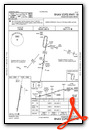
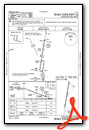
Nearby Airports with Instrument Procedures
| ID | Name | Heading / Distance | ||
|---|---|---|---|---|
 |
KMKN | Comanche County-City Airport | 303° | 27.6 |
|
KSEP | Stephenville Clark Regional Airport | 357° | 32.9 |
|
KLZZ | Lampasas Airport | 184° | 33.6 |
|
81R | San Saba County Municipal Airport | 228° | 38.9 |
|
KGRK | Robert Gray AAF Airport | 155° | 39.4 |
|
KBWD | Brownwood Regional Airport | 280° | 42.0 |
|
KILE | Skylark Field Airport | 145° | 42.1 |
|
KPWG | Mc Gregor Exec Airport | 104° | 44.0 |
|
KACT | Waco Regional Airport | 093° | 47.1 |
|
KTPL | Draughon-Miller Central Texas Regional Airport | 128° | 48.9 |
|
KGDJ | Granbury Regional Airport | 019° | 49.4 |
|
KCNW | Tstc Waco Airport | 091° | 55.1 |
Airport Images

By: jtrolinger


Comments
The tumbleweeds are blowing but the runway is newly paved
The tumbleweeds are blowing but the runway is newly paved and there is a crew car. Good fuel pumps and the lounge has A/C.