Login
Register


AID
Anderson Regional Airport
Official FAA Data Effective 2026-01-22 0901Z
Chart Supplement

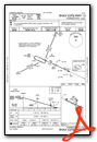
KAID Airport Diagram

VFR Chart of KAID
Sectional Charts at SkyVector.com
IFR Chart of KAID
Enroute Charts at SkyVector.com
Location Information for KAID
Coordinates: N40°6.52' / W85°36.78'Located 03 miles E of Anderson, Indiana on 619 acres of land. View all Airports in Indiana.
Surveyed Elevation is 919 feet MSL.
Operations Data
|
|
Airport Communications
| AWOS-3: | 128.55 Tel. 765-442-1245 |
|---|---|
| ANDERSON TOWER: | 126.0 |
| ANDERSON GROUND: | 121.6 |
| INDIANAPOLIS APPROACH: | 120.65 317.8 |
| INDIANAPOLIS DEPARTURE: | 120.65 317.8 |
| UNICOM: | 122.950 |
| CTAF: | 126.000 |
| ATIS at MIE (12.8 NE): | 133.25 |
| ASOS at MIE (12.8 NE): | 114.4 765-288-9617 |
| AWOS-3 at UWL (19.1 SE): | 132.375 765-422-5701 |
- APCH/DEP SVC PRVDD BY INDIANAPOLIS TRACON ON FREQS 120.65/317.8.
Nearby Navigation Aids
|
| ||||||||||||||||||||||||||||||||||||||||||||||||||||||||||||


Runway 12/30
| Dimensions: | 5400 x 100 feet / 1646 x 30 meters | |
|---|---|---|
| Surface: | Asphalt / Grooved in Excellent Condition | |
| Weight Limits: | 44 /F/C/Y/T, S-112, D-158, ST-279 | |
| Edge Lighting: | Medium Intensity | |
| Runway 12 | Runway 30 | |
| Coordinates: | N40°6.72' / W85°37.38' | N40°6.34' / W85°36.33' |
| Elevation: | 880.1 | 919.0 |
| Traffic Pattern: | Left | Left |
| Runway Heading: | 115° True | 295° True |
| Displaced Threshold: | 80 Feet | |
| Markings: | Precision Instrument in good condition. | Precision Instrument in good condition. |
| Glide Slope Indicator | P4L (3.00° Glide Path Angle) | P4L (3.00° Glide Path Angle) |
| Approach Lights: | MALSF 1,400 Foot Medium-intensity Approach Lighting System with sequenced flashers. | |
| REIL: | Yes | |
| Obstacles: | 117 ft Trees 1831 ft from runway, 519 ft right of center | 50 ft Trees 1700 ft from runway, 30 ft left of center APCH RATIO 35:1 TO DSPLCD THR. |
Runway 18/36
NOT AVBL TO ACR MORE THAN 30 PAX SEATS. | ||
| Dimensions: | 3399 x 75 feet / 1036 x 23 meters | |
|---|---|---|
| Surface: | Asphalt / Grooved in Good Condition | |
| Weight Limits: | 14 /F/C/Y/T, S-38, D-56 | |
| Edge Lighting: | Medium Intensity | |
| Runway 18 | Runway 36 | |
| Coordinates: | N40°6.78' / W85°36.67' | N40°6.22' / W85°36.66' |
| Elevation: | 912.7 | 908.0 |
| Traffic Pattern: | Left | Left |
| Runway Heading: | 180° True | 360° True |
| Displaced Threshold: | 291 Feet | 288 Feet |
| Declared Distances: | LDA:3108 | LDA:3111 |
| Markings: | Basic in fair condition. | Basic in fair condition. |
| Glide Slope Indicator | P2L (3.00° Glide Path Angle) | |
| Obstacles: | 63 ft Tree 1314 ft from runway, 134 ft right of center APCH RATIO 24:1 TO DSPLCD THR. 11 FT RD 170 FT FM RWY END. |
98 ft Trees 1900 ft from runway, 100 ft left of center APCH RATIO 22:1 TO DSPLCD THR. |
Services Available
| Fuel: | 100LL (blue), Jet-A, Automotive Gasoline |
|---|---|
| Transient Storage: | Hangars,Tiedowns |
| Airframe Repair: | MAJOR |
| Engine Repair: | MAJOR |
| Bottled Oxygen: | NOT AVAILABLE |
| Bulk Oxygen: | NONE |
| Other Services: | AIR FREIGHT SERVICES,CHARTER SERVICE,PILOT INSTRUCTION,AIRCRAFT RENTAL,AIRCRAFT SALES |
Ownership Information
| Ownership: | Publicly owned | |
|---|---|---|
| Owner: | CITY OF ANDERSON | |
| 282 AIRPORT RD | ||
| ANDERSON, IN 46017 | ||
| 765-648-6293 | ||
| Manager: | BRIAN MCMILLEN | |
| 282 AIRPORT RD. | ||
| ANDERSON, IN 46017 | ||
| 765-648-6292 | ||
Other Remarks
- DEP RWY 12, 18 & 36 UN TO SEE EACH OTHER.
- DEER ON & INVOF ARPT.
- TWY B CLSD INDEFLY.
- WHEN ATCT IS CLSD FOR CD CTC INDIANAPOLIS APCH AT 317-227-5743.
- GND COM OUTLET 121.725 COMMISSIONED KEY FREQ 4 TIMES.
- TRML NOT STAFFED ON SUNDAYS - AMGR.
- SELF SERVE FUEL AVBL H24.
- WHEN TWR CLSD ACTVT MALSF RWY 30; PAPI RWY 12 & 18; MIRL RWY 12/30 & 18/36 - CTAF.
Weather Minimums


Instrument Approach Procedure (IAP) Charts


Nearby Airports with Instrument Procedures
| ID | Name | Heading / Distance | ||
|---|---|---|---|---|
 |
KMIE | Delaware County Regional Airport | 051° | 12.8 |
|
KUWL | New Castle Henry County Marlatt Field Airport | 136° | 19.2 |
|
KMQJ | Indianapolis Regional Airport | 219° | 20.6 |
|
KUMP | Indianapolis Metro Airport | 242° | 22.5 |
|
KMZZ | Marion Municipal - Mckinney Field Airport | 352° | 23.1 |
|
5I4 | Sheridan Airport | 278° | 28.1 |
|
KTYQ | Indianapolis Exec Airport | 260° | 29.8 |
|
I22 | Randolph County Airport | 083° | 31.7 |
|
KOKK | Kokomo Municipal Airport | 320° | 32.4 |
|
KGEZ | Shelbyville Municipal Airport | 195° | 32.7 |
|
KCEV | Mettel Field Airport | 137° | 33.2 |
|
KPLD | Portland Municipal Airport | 054° | 35.2 |
Airport Images

By: andersonmunicip...


