Login
Register


OKK
Kokomo Municipal Airport
Official FAA Data Effective 2026-01-22 0901Z
Chart Supplement

VFR Chart of KOKK
Sectional Charts at SkyVector.com
IFR Chart of KOKK
Enroute Charts at SkyVector.com
Location Information for KOKK
Coordinates: N40°31.66' / W86°3.58'Located 04 miles NE of Kokomo, Indiana on 590 acres of land. View all Airports in Indiana.
Surveyed Elevation is 832 feet MSL.
Operations Data
|
|
Airport Communications
| AWOS-3PT: | 128.675 Tel. 765-452-3014 |
|---|---|
| GRISSOM APPROACH: | 121.05 338.275 |
| GRISSOM DEPARTURE: | 121.05 338.275 |
| CLEARANCE DELIVERY: | 120.0 |
| UNICOM: | 123.000 |
| CTAF: | 123.000 |
| ATIS at GUS (8.4 NW): | 270.8 |
| AWOS-3 at MZZ (17.5 E): | 108.6 765-674-1317 |
| AWOS-3P at GGP (18.0 NW): | 118.5 574-737-7310 |
- APCH/DEP SVC PRVDD BY CHICAGO ARTCC ON FREQS 121.05 (REMOTED FROM GRISSOM) WHEN GRISSOM APCH CTL CLSD.
Nearby Navigation Aids
|
| ||||||||||||||||||||||||||||||||||||||||||||||||||||||||||||


Runway 05/23
| Dimensions: | 6001 x 150 feet / 1829 x 46 meters | |
|---|---|---|
| Surface: | Asphalt / Grooved in Good Condition | |
| Weight Limits: | S-56, D-75, ST-95 | |
| Edge Lighting: | High Intensity | |
| Runway 05 | Runway 23 | |
| Coordinates: | N40°31.26' / W86°4.16' | N40°31.96' / W86°3.24' |
| Elevation: | 832.2 | 819.0 |
| Traffic Pattern: | Left | Left |
| Runway Heading: | 45° True | 225° True |
| Markings: | Non-Precision Instrument in good condition. | Precision Instrument in good condition. |
| Glide Slope Indicator | P2L (3.00° Glide Path Angle) | |
| Approach Lights: | MALSR 1,400 Foot Medium-intensity Approach Lighting System with runway alignment indicator lights. | |
| REIL: | Yes | |
| Obstacles: | CROPS 230 FT R & 350 FT L OF CL |
53 ft Tree 1080 ft from runway, 625 ft right of center CROPS 140 FT R OF CL |
Runway 14/32
| Dimensions: | 4001 x 150 feet / 1220 x 46 meters | |
|---|---|---|
| Surface: | Asphalt / Grooved in Good Condition | |
| Weight Limits: | S-50, D-60, ST-95 | |
| Edge Lighting: | Medium Intensity | |
| Runway 14 | Runway 32 | |
| Coordinates: | N40°31.96' / W86°3.71' | N40°31.49' / W86°3.10' |
| Elevation: | 825.9 | 823.6 |
| Traffic Pattern: | Left | Left |
| Runway Heading: | 135° True | 315° True |
| Markings: | Non-Precision Instrument in good condition. | Non-Precision Instrument in good condition. |
| Glide Slope Indicator | P2L (3.17° Glide Path Angle) | P2L (3.18° Glide Path Angle) |
| REIL: | Yes | Yes |
Services Available
| Fuel: | 100LL (blue), Jet A-1+ |
|---|---|
| Transient Storage: | Hangars,Tiedowns |
| Airframe Repair: | MAJOR |
| Engine Repair: | MAJOR |
| Bottled Oxygen: | NONE |
| Bulk Oxygen: | NONE |
| Other Services: | PILOT INSTRUCTION,AIRCRAFT RENTAL,AIRCRAFT SALES |
Ownership Information
| Ownership: | Publicly owned | |
|---|---|---|
| Owner: | KOKOMO BOAC | |
| 3637 E COUNTY RD 400N | ||
| KOKOMO, IN 46901 | ||
| 765-456-7541 | ||
| Manager: | SHAUN BAKER | |
| 3637 E COUNTY RD 400N | ||
| KOKOMO, IN 46901 | ||
| 765-456-1742 | 765-456-7542 EXT 5413. | |
Other Remarks
- ACTVT MALSR RWY 23; REIL RWY 05 & 14/32; PAPI RWY 05, 14, 32; HIRL RWY 05/23; MIRL RWY 14/32 - CTAF.
Weather Minimums


Instrument Approach Procedure (IAP) Charts
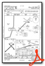
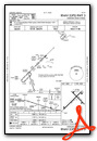
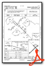
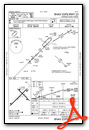

Nearby Airports with Instrument Procedures
| ID | Name | Heading / Distance | ||
|---|---|---|---|---|
 |
KGUS | Grissom Arb Airport | 329° | 8.4 |
|
I76 | Peru Municipal Airport | 345° | 16.0 |
|
KMZZ | Marion Municipal - Mckinney Field Airport | 097° | 17.5 |
|
KGGP | Logansport/Cass County Airport | 307° | 18.0 |
|
KIWH | Wabash Municipal Airport | 040° | 18.4 |
|
5I4 | Sheridan Airport | 199° | 22.2 |
|
KFKR | Frankfort Clinton County Regional Airport | 236° | 27.6 |
|
1I9 | Delphi Municipal Airport | 271° | 28.5 |
|
KTYQ | Indianapolis Exec Airport | 196° | 31.2 |
|
KAID | Anderson Regional Airport | 140° | 32.4 |
|
KRCR | Fulton County Airport | 350° | 32.7 |
|
KHHG | Huntington Municipal Airport | 054° | 33.7 |
Airport Images
Do you have a recent image of this airport? Upload it here!


