Login
Register


UWL
New Castle Henry County Marlatt Field Airport
Official FAA Data Effective 2026-02-19 0901Z
Chart Supplement

VFR Chart of KUWL
Sectional Charts at SkyVector.com
IFR Chart of KUWL
Enroute Charts at SkyVector.com
Location Information for KUWL
Coordinates: N39°52.60' / W85°19.52'Located 04 miles SE of New Castle, Indiana on 100 acres of land. View all Airports in Indiana.
Surveyed Elevation is 1090 feet MSL.
Operations Data
|
|
Airport Communications
| AWOS-3: | 132.375 Tel. 765-422-5701 |
|---|---|
| INDIANAPOLIS APPROACH: | 135.45 317.8 |
| INDIANAPOLIS DEPARTURE: | 135.45 317.8 |
| CTAF: | 123.050 |
| UNICOM: | 123.050 |
| AWOS-3 at CEV (14.0 SE): | 118.325 765-827-6649 |
| AWOS-3 at AID (19.2 NW): | 128.55 765-442-1245 |
| ATIS at MIE (22.2 N): | 133.25 |
Nearby Navigation Aids
|
| ||||||||||||||||||||||||||||||||||||||||||||||||||||||||||||


Runway 10/28
| Dimensions: | 4201 x 75 feet / 1280 x 23 meters | |
|---|---|---|
| Surface: | Asphalt in Good Condition | |
| Edge Lighting: | Medium Intensity | |
| Runway 10 | Runway 28 | |
| Coordinates: | N39°52.61' / W85°19.97' | N39°52.60' / W85°19.07' |
| Elevation: | 1080.1 | 1090.2 |
| Runway Heading: | 90° True | 270° True |
| Markings: | Non-Precision Instrument in good condition. | Non-Precision Instrument in good condition. |
| Glide Slope Indicator | P2L (3.00° Glide Path Angle) | P2L (3.00° Glide Path Angle) |
| REIL: | Yes | Yes |
| Obstacles: | 10 ft Crops 340 ft from runway | 10 ft Crops 210 ft from runway |
Services Available
| Fuel: | 100LL (blue), Jet-A |
|---|---|
| Transient Storage: | Hangars,Tiedowns |
| Airframe Repair: | MINOR |
| Engine Repair: | MINOR |
| Bottled Oxygen: | NOT AVAILABLE |
| Bulk Oxygen: | NOT AVAILABLE |
| Other Services: | AIR FREIGHT SERVICES,AIR AMBULANCE SERVICES,CARGO HANDLING SERVICES,CHARTER SERVICE,PILOT INSTRUCTION,AIRCRAFT RENTAL |
Ownership Information
| Ownership: | Publicly owned | |
|---|---|---|
| Owner: | NEW CASTLE/HENRY COUNTY | |
| 2912 E. CO. RD. 400 S. | ||
| NEW CASTLE, IN 47362 | ||
| 765-529-7903 | ||
| Manager: | JOHN MARLATT | |
| 2912 E CO. RD 400 S | ||
| NEW CASTLE, IN 47362 | ||
| 765-529-7903 | 765-529-7909. | |
Other Remarks
- FOR CD CTC INDIANAPOLIS APCH AT 317-227-5743.
- ACTVT REIL RWY 10 & 28; PAPI RWY 10 & 28; MIRL RWY 10/28 - CTAF. MIRL RWY 10/28 PRESET LOW INTST; INCR INTST - CTAF.
Weather Minimums

Instrument Approach Procedure (IAP) Charts


Nearby Airports with Instrument Procedures
| ID | Name | Heading / Distance | ||
|---|---|---|---|---|
 |
KCEV | Mettel Field Airport | 139° | 14.0 |
|
KAID | Anderson Regional Airport | 316° | 19.2 |
|
KMIE | Delaware County Regional Airport | 351° | 22.2 |
|
KRID | Richmond Municipal Airport | 107° | 23.5 |
|
I22 | Randolph County Airport | 046° | 25.2 |
|
KMQJ | Indianapolis Regional Airport | 265° | 26.5 |
|
KGEZ | Shelbyville Municipal Airport | 231° | 28.3 |
|
KUMP | Indianapolis Metro Airport | 276° | 33.4 |
|
KOXD | Miami University Airport | 131° | 33.6 |
|
I34 | Greensburg Municipal Airport | 195° | 34.6 |
|
KPLD | Portland Municipal Airport | 023° | 37.7 |
|
KHFY | Indy South Greenwood Airport | 247° | 38.3 |
Airport Images
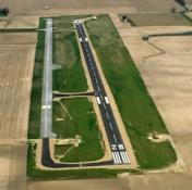
By: Rangerider49

By: Pbergen


