Login
Register


GEZ
Shelbyville Municipal Airport
Official FAA Data Effective 2026-01-22 0901Z
Chart Supplement

VFR Chart of KGEZ
Sectional Charts at SkyVector.com
IFR Chart of KGEZ
Enroute Charts at SkyVector.com
Location Information for KGEZ
Coordinates: N39°34.99' / W85°48.29'Located 04 miles NW of Shelbyville, Indiana on 550 acres of land. View all Airports in Indiana.
Surveyed Elevation is 802 feet MSL.
Operations Data
|
|
Airport Communications
| ASOS: | 121.55 Tel. 317-398-0246 |
|---|---|
| INDIANAPOLIS APPROACH: | 127.15 317.8 |
| INDIANAPOLIS DEPARTURE: | 127.15 317.8 |
| UNICOM: | 122.800 |
| CTAF: | 122.800 |
| AWOS-3P at HFY (13.4 W): | 118.525 317-882-5862 |
| AWOS-3PT at MQJ (16.0 N): | 124.175 317-335-3037 |
| AWOS-3 at 8A4 (19.3 NW): | 135.525 317-955-3160 |
Nearby Navigation Aids
|
| ||||||||||||||||||||||||||||||||||||||||||||||||||||||||||||


Runway 01/19
| Dimensions: | 5000 x 100 feet / 1524 x 30 meters | |
|---|---|---|
| Surface: | Asphalt / Grooved in Good Condition | |
| Weight Limits: | S-30, D-40 | |
| Edge Lighting: | Medium Intensity | |
| Runway 01 | Runway 19 | |
| Coordinates: | N39°34.78' / W85°48.28' | N39°35.60' / W85°48.20' |
| Elevation: | 801.3 | 802.3 |
| Runway Heading: | 5° True | 185° True |
| Markings: | Non-Precision Instrument in good condition. | Non-Precision Instrument in good condition. |
| Glide Slope Indicator | P2L (3.00° Glide Path Angle) | V4L (3.00° Glide Path Angle) |
| REIL: | Yes | Yes |
Runway 09/27
| Dimensions: | 2671 x 190 feet / 814 x 58 meters | |
|---|---|---|
| Surface: | Turf in Good Condition | |
| Runway 09 | Runway 27 | |
| Coordinates: | N39°34.63' / W85°48.67' | N39°34.61' / W85°48.10' |
| Elevation: | 790.0 | 800.0 |
| Traffic Pattern: | Left | Left |
| Runway Heading: | 92° True | 272° True |
| Displaced Threshold: | 446 Feet RY 09/27 DSPLCD THLDS MKD WITH YELLOW CONES. |
289 Feet |
| Markings: | None | None |
| Obstacles: | 150 ft Road 15 ft from runway APCH SLOPE 40:1 AT DSPLCD THR. |
23 ft Building 325 ft from runway, 120 ft right of center APCH RATIO 27:1 TO DSPLCD THLD. |
Services Available
| Fuel: | 100LL (blue), Jet-A |
|---|---|
| Transient Storage: | Tiedowns |
| Airframe Repair: | MAJOR |
| Engine Repair: | MAJOR |
| Bottled Oxygen: | NONE |
| Bulk Oxygen: | NONE |
| Other Services: | PILOT INSTRUCTION,AIRCRAFT RENTAL |
Ownership Information
| Ownership: | Publicly owned | |
|---|---|---|
| Owner: | SHELBYVILLE BOAC | |
| 44 W WASHINGTON ST | ||
| SHELBYVILLE, IN 46176 | ||
| 317-398-6624 | ||
| Manager: | MARANDA SMITH | GEZ@AEROMANAGEMENTGROUP.COM |
| 3529 N 100 WEST | ||
| SHELBYVILLE, IN 46176 | ||
| 317-392-1284 | ||
Other Remarks
- THIS AIRPORT HAS BEEN SURVEYED BY THE NATIONAL GEODETIC SURVEY.
- HELICOPTER TFC ALL HRS. ANG HELI LCTD W OF ARPT.
- NG HELIPAD & HELICOPTER FACILITY LCTD WEST OF ARPT.
- CTC ANG OPS 41.5/143.6/347.55.
- RWY BEGINS W SIDE OF TWY A; GRASS LINE MARKS RWY EDGES.
- 0LL 100LL SELF SERVE AVBL
- MIRL RY 01/19 PRESET ON LOW INTST; TO INCR INTST & ACTVT REIL RY 01/19; PAPI RY 01 & VASI RY 19; MIRL RY 01/19 - CTAF
Weather Minimums


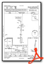
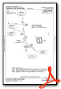
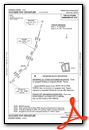
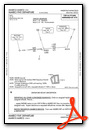
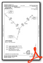
Instrument Approach Procedure (IAP) Charts
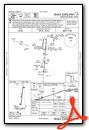

Departure Procedure (DP) Charts

Nearby Airports with Instrument Procedures
| ID | Name | Heading / Distance | ||
|---|---|---|---|---|
 |
KHFY | Indy South Greenwood Airport | 281° | 13.4 |
|
KMQJ | Indianapolis Regional Airport | 344° | 16.2 |
|
KBAK | Columbus Municipal Airport | 192° | 19.7 |
|
I34 | Greensburg Municipal Airport | 140° | 20.4 |
|
KUMP | Indianapolis Metro Airport | 332° | 23.9 |
|
KIND | Indianapolis International Airport | 289° | 24.1 |
|
KEYE | Eagle Creek Airpark Airport | 303° | 27.1 |
|
KUWL | New Castle Henry County Marlatt Field Airport | 051° | 28.3 |
|
KCEV | Mettel Field Airport | 077° | 32.0 |
|
2R2 | Hendricks County-Gordon Graham Field Airport | 287° | 32.6 |
|
KAID | Anderson Regional Airport | 015° | 32.7 |
|
KOVO | North Vernon Airport | 163° | 33.5 |
Airport Images
Do you have a recent image of this airport? Upload it here!


