Login
Register
PLD
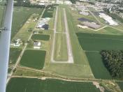
Portland Municipal Airport
Official FAA Data Effective 2026-02-19 0901Z
VFR Chart of KPLD
Sectional Charts at SkyVector.com
IFR Chart of KPLD
Enroute Charts at SkyVector.com
Location Information for KPLD
Coordinates: N40°27.09' / W84°59.50'Located 01 miles NW of Portland, Indiana on 45 acres of land. View all Airports in Indiana.
Surveyed Elevation is 925 feet MSL.
Operations Data
|
|
Airport Communications
| AWOS-3: | 124.675 Tel. 260-726-7882 |
|---|---|
| FORT WAYNE APPROACH: | 127.2 ;SW/NW OF ACTIVE RWY 132.15 ;SE/NE OF ACTIVE RWY 284.6 |
| FORT WAYNE DEPARTURE: | 127.2 ;SW/NW OF ACTIVE RWY 132.15 ;SE/NE OF ACTIVE RWY 284.6 |
| CTAF: | 122.800 |
| UNICOM: | 122.800 |
| ASOS at MIE (22.3 SW): | 114.4 765-288-9617 |
| ATIS at MIE (22.3 SW): | 133.25 |
| AWOS-3PT at VES (25.6 SE): | 125.9 937-526-3154 |
Nearby Navigation Aids
|
| ||||||||||||||||||||||||||||||||||||||||||||||||||||||||||||
Runway 09/27
| Dimensions: | 5505 x 75 feet / 1678 x 23 meters | |
|---|---|---|
| Surface: | Asphalt / Aggregate Friction Seal Coated in Good Condition | |
| Weight Limits: | S-12 | |
| Edge Lighting: | Medium Intensity | |
| Runway 09 | Runway 27 | |
| Coordinates: | N40°27.08' / W85°0.10' | N40°27.10' / W84°58.91' |
| Elevation: | 907.1 | 925.3 |
| Traffic Pattern: | Left | Left |
| Runway Heading: | 89° True | 269° True |
| Markings: | Non-Precision Instrument in fair condition. | Non-Precision Instrument in fair condition. |
| Glide Slope Indicator | P2L (3.00° Glide Path Angle) | P2L (3.00° Glide Path Angle) PAPI UNUSBL BYD 3 DEGS RIGHT OF CNTRLN. |
| REIL: | Yes | Yes |
| Obstacles: | SEASONAL CROPS. |
24 ft Power Line 950 ft from runway |
Services Available
| Fuel: | 100LL (blue), Jet-A |
|---|---|
| Transient Storage: | Tiedowns |
| Airframe Repair: | NOT AVAILABLE |
| Engine Repair: | NOT AVAILABLE |
| Bottled Oxygen: | NOT AVAILABLE |
| Bulk Oxygen: | NOT AVAILABLE |
| Other Services: | CROP DUSTING SERVICES,CHARTER SERVICE,PILOT INSTRUCTION,AIRCRAFT RENTAL |
Ownership Information
| Ownership: | Publicly owned | |
|---|---|---|
| Owner: | CITY OF PORTLAND | |
| AVN COMM BOARD,CITY HALL | ||
| PORTLAND, IN 47371 | ||
| 260-729-5233 | ||
| Manager: | HAROLD TAVZEL | |
| 661 W 100 N | ||
| PORTLAND, IN 47371 | ||
| 260-729-1577 | ||
Other Remarks
- 150 FT LGTD WATER TWR 1300 FT SE; 120 FT GRAIN ELEV 1300 FT ESE.
- FOR CD CTC CHICAGO ARTCC AT 630-906-8921.
- ACTVT REIL RWY 09 & 27; MIRL RWY 09/27 - CTAF. MIRL RWY 09/27 PRESET LOW INTST; INCR INT - CTAF. PAPI RWY 09 & 27 ON CONSLY.
Weather Minimums
Instrument Approach Procedure (IAP) Charts
Nearby Airports with Instrument Procedures
| ID | Name | Heading / Distance | ||
|---|---|---|---|---|
 |
I22 | Randolph County Airport | 170° | 17.3 |
 |
KCQA | Lakefield Airport | 084° | 19.9 |
 |
KMIE | Delaware County Regional Airport | 236° | 22.4 |
 |
KVES | Darke County Airport | 124° | 25.8 |
 |
KVNW | Van Wert County Airport | 035° | 30.3 |
 |
KMZZ | Marion Municipal - Mckinney Field Airport | 274° | 31.6 |
 |
KAXV | Neil Armstrong Airport | 085° | 31.9 |
 |
KHHG | Huntington Municipal Airport | 318° | 32.1 |
 |
KFWA | Fort Wayne International Airport | 343° | 32.9 |
 |
KAID | Anderson Regional Airport | 234° | 35.2 |
 |
I17 | Piqua/Hartzell Field Airport | 118° | 35.8 |
 |
KUWL | New Castle Henry County Marlatt Field Airport | 204° | 37.7 |


