Login
Register


FYJ
Middle Peninsula Regional Airport
Official FAA Data Effective 2026-02-19 0901Z
Chart Supplement

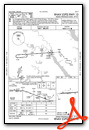
VFR Chart of KFYJ
Sectional Charts at SkyVector.com
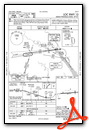
IFR Chart of KFYJ
Enroute Charts at SkyVector.com
Location Information for KFYJ
Coordinates: N37°31.28' / W76°45.76'Located 02 miles SE of West Point, Virginia on 310 acres of land. View all Airports in Virginia.
Surveyed Elevation is 20 feet MSL.
TPA LGT ACFT 800 FT, HVY ACFT 1500 FT.
Operations Data
|
|
Airport Communications
| AWOS-3: | 132.825 Tel. 804-785-2307 |
|---|---|
| POTOMAC APPROACH: | 126.4 126.75 282.375 307.2 |
| POTOMAC DEPARTURE: | 126.4 126.75 282.375 307.2 |
| UNICOM: | 123.000 |
| CTAF: | 123.000 |
| AWOS-3 at W75 (15.8 E): | 118.45 804-758-8592 |
| AWOS-3 at JGG (17.1 S): | 120.625 757-220-8810 |
| AWOS-3 at W96 (17.3 W): | 119.875 804-932-8863 |
Nearby Navigation Aids
|
| ||||||||||||||||||||||||||||||||||||||||||||||||||||||||||||


Runway 10/28
| Dimensions: | 5000 x 75 feet / 1524 x 23 meters | |
|---|---|---|
| Surface: | Asphalt in Good Condition | |
| Weight Limits: | S-30, D-50, ST-85 | |
| Edge Lighting: | Medium Intensity | |
| Runway 10 | Runway 28 | |
| Coordinates: | N37°31.25' / W76°46.28' | N37°31.31' / W76°45.25' |
| Elevation: | 13.0 | 20.4 |
| Traffic Pattern: | Left | Left |
| Runway Heading: | 86° True | 266° True |
| Markings: | Non-Precision Instrument in good condition. | Non-Precision Instrument in good condition. |
| Glide Slope Indicator | P2L (3.50° Glide Path Angle) | P2L (3.50° Glide Path Angle) |
| REIL: | Yes | Yes |
| Obstacles: | 10 ft Tree 302 ft from runway, 78 ft left of center 23 FT TREE; 161 FT FM THR, 243 FT R OF CNTRLN. |
30 ft Trees 336 ft from runway, 137 ft left of center |
Services Available
| Fuel: | 100LL (blue), Jet A+ |
|---|---|
| Transient Storage: | Tiedowns |
| Airframe Repair: | MAJOR |
| Engine Repair: | MAJOR |
| Bottled Oxygen: | NONE |
| Bulk Oxygen: | NONE |
| Other Services: | AIR AMBULANCE SERVICES,PILOT INSTRUCTION,PARACHUTE JUMP ACTIVITY PAJA IRREGULAR. |
Ownership Information
| Ownership: | Publicly owned | |
|---|---|---|
| Owner: | MIDDLE PENISULA REG'L AIRPORT AUTHO | |
| 1000 AIRPORT RD | ||
| MATTAPONI, VA 23110 | ||
| 804-785-9725 | ||
| Manager: | JOEL MOONEY | |
| 1000 AIRPORT RD | ||
| MATTAPONI, VA 23110 | ||
| 804-785-9725 | E-MAIL MANAGER@FLY-FYJ.COM. | |
Other Remarks
- DEER ON & INVOF ARPT.
- ROTOR-WING AND TILTROTOR ACFT FLY TFC PATS SOUTH OF RWY 10/28 AT 800 FT AGL OR ABV.
- FOR CD CTC NORFOLK APCH AT 757-464-0757.
- NON-STD MARKING PLACEMENT. MARKINGS NEED TO SHIFT 8 FT E OF CURRENT PLACEMENT.
- 0LL SELF SVC AVBL.
- FULL & SELF SVC AVBL.
- REIL RWY 10 & 28; MIRL 10/28 OPR SS-SR. DRG DALGT HRS, PCL AVBL ON REQ, CTC AMGR. ACTVT REIL RWY 10 & 28; MIRL 10/28 - CTAF.
- TPA LGT ACFT 800 FT, HVY ACFT 1500 FT.
Weather Minimums

Instrument Approach Procedure (IAP) Charts


Nearby Airports with Instrument Procedures
| ID | Name | Heading / Distance | ||
|---|---|---|---|---|
 |
W75 | Hummel Field Airport | 071° | 15.9 |
|
KJGG | Waltrip Williamsburg Exec Airport Airport | 172° | 17.1 |
|
W96 | New Kent County Airport | 266° | 17.4 |
|
KXSA | Tappahannock/Essex County Airport | 342° | 21.2 |
|
KFAF | Felker AAF Airport | 162° | 24.4 |
|
KRIC | Richmond International Airport | 268° | 26.6 |
|
KPHF | Newport News/Williamsburg International Airport | 150° | 26.7 |
|
KLFI | Langley AFB Airport | 143° | 32.6 |
|
KOFP | Hanover County Municipal Airport | 289° | 34.0 |
|
KAKQ | Wakefield Municipal Airport | 199° | 34.0 |
|
KFCI | Richmond Exec/Chesterfield County Airport | 259° | 37.0 |
|
KTGI | Tangier Island Airport | 063° | 40.8 |
Airport Images
Do you have a recent image of this airport? Upload it here!


