Login
Register


W96
New Kent County Airport
Official FAA Data Effective 2026-01-22 0901Z
Chart Supplement

VFR Chart of W96
Sectional Charts at SkyVector.com
IFR Chart of W96
Enroute Charts at SkyVector.com
Location Information for W96
Coordinates: N37°30.21' / W77°7.59'Located 08 miles W of Quinton, Virginia on 150 acres of land. View all Airports in Virginia.
Surveyed Elevation is 120 feet MSL.
Operations Data
|
|
Airport Communications
| AWOS-3: | 119.875 Tel. 804-932-8863 |
|---|---|
| POTOMAC APPROACH: | 126.4 282.375 |
| POTOMAC DEPARTURE: | 126.4 282.375 |
| CTAF: | 122.800 |
| UNICOM: | 122.800 |
| ATIS at RIC (9.2 W): | 263.025 |
| ASOS at RIC (9.4 W): | 804-223-6573 |
| AWOS-3 at FYJ (17.4 E): | 132.825 804-785-2307 |
Nearby Navigation Aids
|
| ||||||||||||||||||||||||||||||||||||||||||||||||||||||||||||


Runway 11/29
| Dimensions: | 3602 x 75 feet / 1098 x 23 meters | |
|---|---|---|
| Surface: | Asphalt in Good Condition | |
| Weight Limits: | S-12 | |
| Edge Lighting: | Medium Intensity | |
| Runway 11 | Runway 29 | |
| Coordinates: | N37°30.24' / W77°7.96' | N37°30.17' / W77°7.22' |
| Elevation: | 120.7 | 107.5 |
| Traffic Pattern: | Left | Left |
| Runway Heading: | 96° True | 276° True |
| Markings: | Non-Precision Instrument in fair condition. | Non-Precision Instrument in fair condition. |
| Glide Slope Indicator | P2R (4.00° Glide Path Angle) | P2L (4.00° Glide Path Angle) |
| REIL: | Yes | Yes |
| Obstacles: | 5 ft Road 258 ft from runway RWY 11 - ROADWAY +15 FT 260 FT FM RWY END. |
20 ft Trees 438 ft from runway, 165 ft right of center 13 FT BRUSH, 101 FT RIGHT OF CTRLN ON APCH AT THLD. |
Services Available
| Fuel: | 100LL (blue) |
|---|---|
| Transient Storage: | Hangars,Tiedowns |
| Airframe Repair: | MINOR |
| Engine Repair: | MINOR |
| Bottled Oxygen: | NONE |
| Bulk Oxygen: | NONE |
Ownership Information
| Ownership: | Publicly owned | |
|---|---|---|
| Owner: | COUNTY OF NEW KENT | |
| P. O. BOX 150, 12007 COURT HOUSE CIRCLE | ||
| NEW KENT, VA 23124 | ||
| 804-966-9683 | ||
| Manager: | DUANE GOSS | |
| 6901 TERMINAL RD | ||
| QUINTON, VA 23141-2427 | ||
| 804-932-3984 | ||
Other Remarks
- DEER ON & INVOF ARPT.
- FOR CD CTC POTOMAC APCH AT 866-640-4124.
- 0LL FUEL AVBL 24 HRS, CREDIT CARD REQUIRED WHEN UNATTENDED.
- ACTVT REIL RWY 11 & 29; MIRL RWY 11/29 - CTAF.
Weather Minimums

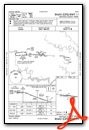
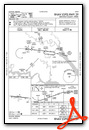
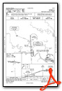
Instrument Approach Procedure (IAP) Charts
Nearby Airports with Instrument Procedures
| ID | Name | Heading / Distance | ||
|---|---|---|---|---|
 |
KRIC | Richmond International Airport | 270° | 9.2 |
|
KFYJ | Middle Peninsula Regional Airport | 086° | 17.4 |
|
KOFP | Hanover County Municipal Airport | 309° | 19.2 |
|
KFCI | Richmond Exec/Chesterfield County Airport | 253° | 19.9 |
|
KXSA | Tappahannock/Essex County Airport | 027° | 24.0 |
|
KJGG | Waltrip Williamsburg Exec Airport Airport | 128° | 25.2 |
|
KPTB | Tri Cities Exec/Dinwiddie County Airport | 223° | 26.4 |
|
KAKQ | Wakefield Municipal Airport | 168° | 31.5 |
|
W75 | Hummel Field Airport | 079° | 33.0 |
|
KFAF | Felker AAF Airport | 131° | 33.3 |
|
KPHF | Newport News/Williamsburg International Airport | 126° | 37.6 |
|
7W4 | Lake Anna Airport | 313° | 40.5 |
Airport Images

By: freakytree


