Login
Register


CLI
Clintonville Municipal Airport
Official FAA Data Effective 2026-01-22 0901Z
Chart Supplement

VFR Chart of KCLI
Sectional Charts at SkyVector.com
IFR Chart of KCLI
Enroute Charts at SkyVector.com
Location Information for KCLI
Coordinates: N44°36.79' / W88°43.85'Located 01 miles SE of Clintonville, Wisconsin on 533 acres of land. View all Airports in Wisconsin.
Surveyed Elevation is 825 feet MSL.
Operations Data
|
|
Airport Communications
| AWOS-3: | 120.675 Tel. 715-823-7691 |
|---|---|
| GREEN BAY APPROACH: | 126.3 338.2 |
| GREEN BAY DEPARTURE: | 126.3 338.2 |
| UNICOM: | 122.800 |
| CTAF: | 122.800 |
| AWOS-3 at EZS (12.6 NE): | 118.65 715-526-2967 |
| AWOS-3 at PCZ (20.9 SW): | 118.625 920-867-2407 |
| ATIS at ATW (23.2 SE): | 127.15 |
- APCH/DEP SVC PRVDD BY MINNEAPOLIS ARTCC ON 124.4/317.7 (MOSINEE RCAG) WHEN GREEN BAY APCH CLSD.
Nearby Navigation Aids
|
| ||||||||||||||||||||||||||||||||||||||||||||||||||||||


Runway 14/32
| Dimensions: | 4599 x 75 feet / 1402 x 23 meters | |
|---|---|---|
| Surface: | Asphalt in Fair Condition | |
| Weight Limits: | S-30, D-55 | |
| Edge Lighting: | Medium Intensity | |
| Runway 14 | Runway 32 | |
| Coordinates: | N44°37.08' / W88°44.29' | N44°36.53' / W88°43.57' |
| Elevation: | 818.5 | 814.7 |
| Traffic Pattern: | Left | Left |
| Runway Heading: | 137° True | 317° True |
| Markings: | Non-Precision Instrument in good condition. | Non-Precision Instrument in good condition. |
| Glide Slope Indicator | P2L (3.00° Glide Path Angle) | |
| REIL: | Yes | |
| Obstacles: | 79 ft Trees 1300 ft from runway, 375 ft right of center | 37 ft Trees 355 ft from runway, 260 ft left of center |
Runway 04/22
| Dimensions: | 3812 x 75 feet / 1162 x 23 meters | |
|---|---|---|
| Surface: | Asphalt in Good Condition | |
| Weight Limits: | S-40, D-70 | |
| Edge Lighting: | Medium Intensity | |
| Runway 04 | Runway 22 | |
| Coordinates: | N44°36.59' / W88°44.12' | N44°37.06' / W88°43.53' |
| Elevation: | 825.9 | 810.6 |
| Traffic Pattern: | Left | Left |
| Runway Heading: | 43° True | 223° True |
| Markings: | Non-Precision Instrument in good condition. | Non-Precision Instrument in good condition. |
Runway 09/27
CLSD FM 1 DEC TO 15 APR; TO CONFIRM RWY COND OTR TIMES CTC AMGR. | ||
| Dimensions: | 2002 x 170 feet / 610 x 52 meters | |
|---|---|---|
| Surface: | Turf in Fair Condition | |
| Runway 09 | Runway 27 | |
| Coordinates: | N44°36.68' / W88°43.96' | N44°36.69' / W88°43.50' |
| Elevation: | 818.4 | 811.9 |
| Traffic Pattern: | Left | Left |
| Runway Heading: | 89° True | 268° True |
| Markings: | None | None |
Services Available
| Fuel: | 100LL (blue), Jet A+ |
|---|---|
| Transient Storage: | Hangars,Tiedowns |
| Airframe Repair: | NONE |
| Engine Repair: | NONE |
| Bottled Oxygen: | NOT AVAILABLE |
| Bulk Oxygen: | NOT AVAILABLE |
| Other Services: | AVIONICS,PILOT INSTRUCTION |
Ownership Information
| Ownership: | Publicly owned | |
|---|---|---|
| Owner: | CITY OF CLINTONVILLE | |
| CITY HALL; 50 TENTH STREET | ||
| CLINTONVILLE, WI 54929 | ||
| 715-823-7600 | ||
| Manager: | CAZ MUSKE | |
| 50 10TH ST | ||
| CLINTONVILLE, WI 54929 | ||
| (715) 250-0220 | ||
Other Remarks
- DEER, FOX & BIRDS ON & INVOF ARPT.
- FOR CD CTC GREEN BAY APCH AT 920-431-5741. WHEN APCH CLSD, CTC MINNEAPOLIS ARTCC AT 651-463-5588.
- MKD WITH WHITE CONES.
- MKD WITH WHITE CONES.
- 0LL 24 HR SELF SVC FUEL AVBL WITH CREDIT CARD.
- MIRL RWY 04/22 & RWY 14/32 PRESET TO LOW SS-SR; TO INCR INTST & ACTVT REIL RWY 32; MIRL RWY 04/22 & 14/32 - CTAF. PAPI RWY 32 OPRS CONSLY.
Weather Minimums


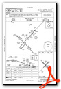
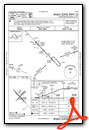
Instrument Approach Procedure (IAP) Charts


Nearby Airports with Instrument Procedures
| ID | Name | Heading / Distance | ||
|---|---|---|---|---|
 |
KEZS | Shawano Municipal Airport | 034° | 12.8 |
|
KPCZ | Waupaca Municipal Airport | 216° | 20.9 |
|
KATW | Appleton International Airport | 156° | 23.2 |
|
KGRB | Green Bay/Austin Straubel International Airport | 106° | 26.9 |
|
KSTE | Stevens Point Municipal Airport | 263° | 34.5 |
|
KAIG | Langlade County Airport | 333° | 36.3 |
|
KOCQ | Oconto/J Douglas Bake Municipal Airport | 065° | 38.4 |
|
KOSH | Wittman Regional Airport | 168° | 38.5 |
|
KCWA | Central Wisconsin Airport | 284° | 41.2 |
|
Y50 | Wautoma Municipal Airport | 216° | 42.2 |
|
KAUW | Wausau Downtown Airport | 296° | 42.7 |
|
8D1 | New Holstein Municipal Airport | 146° | 48.1 |
Airport Images
Do you have a recent image of this airport? Upload it here!


