Login
Register


PCZ
Waupaca Municipal Airport
Official FAA Data Effective 2026-02-19 0901Z
Chart Supplement

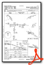
VFR Chart of KPCZ
Sectional Charts at SkyVector.com
IFR Chart of KPCZ
Enroute Charts at SkyVector.com
Location Information for KPCZ
Coordinates: N44°19.99' / W89°1.19'Located 03 miles SE of Waupaca, Wisconsin on 386 acres of land. View all Airports in Wisconsin.
Surveyed Elevation is 840 feet MSL.
Operations Data
|
|
Airport Communications
| AWOS-3: | 118.625 Tel. 920-867-2407 |
|---|---|
| MINNEAPOLIS ARTCC APPROACH: | 126.3 |
| MINNEAPOLIS ARTCC DEPARTURE: | 126.3 |
| UNICOM: | 122.800 |
| CTAF: | 122.800 |
| AWOS-3 at CLI (20.9 NE): | 120.675 715-823-7691 |
| AWOS-3PT at Y50 (21.3 SW): | 119.475 920-787-0515 |
| AWOS-3 at ATW (21.8 E): | 920-832-2597 |
- APCH/DEP SVC PRVDD BY MINNEAPOLIS ARTCC ON FREQS 124.4/317.7 (MOSINEE RCAG).
Nearby Navigation Aids
|
| ||||||||||||||||||||||||||||||||||||||||||||||||||||||||||||


Runway 10/28
| Dimensions: | 5200 x 100 feet / 1585 x 30 meters | |
|---|---|---|
| Surface: | Asphalt in Fair Condition | |
| Edge Lighting: | Medium Intensity | |
| Runway 10 | Runway 28 | |
| Coordinates: | N44°20.00' / W89°1.97' | N44°19.95' / W89°0.78' |
| Elevation: | 840.0 | 805.2 |
| Traffic Pattern: | Left | Left |
| Runway Heading: | 93° True | 273° True |
| Markings: | Non-Precision Instrument in fair condition. | Non-Precision Instrument in fair condition. |
| Glide Slope Indicator | P2L (3.00° Glide Path Angle) PAPI ON CONTINUOUSLY. | P2L (3.00° Glide Path Angle) PAPI ON CONTINUOUSLY. |
| REIL: | Yes | Yes |
| Obstacles: | 59 ft Trees 1500 ft from runway, 350 ft right of center | |
Runway 13/31
| Dimensions: | 3899 x 75 feet / 1188 x 23 meters | |
|---|---|---|
| Surface: | Asphalt in Poor Condition NMRS CRACKS AND VEGETATION IN PAVEMENT. | |
| Weight Limits: | S-13 | |
| Edge Lighting: | Medium Intensity | |
| Runway 13 | Runway 31 | |
| Coordinates: | N44°20.20' / W89°1.30' | N44°19.84' / W89°0.56' |
| Elevation: | 826.6 | 802.8 |
| Traffic Pattern: | Left | Left |
| Runway Heading: | 123° True | 303° True |
| Markings: | Non-Precision Instrument in poor condition. | Non-Precision Instrument in poor condition. |
| Glide Slope Indicator | P4L (4.00° Glide Path Angle) PAPI ON CONTINUOUSLY. | P2L (3.00° Glide Path Angle) PAPI ON CONTINUOUSLY. |
| Obstacles: | 75 ft Trees 1330 ft from runway, 210 ft right of center | |
Services Available
| Fuel: | 100LL (blue), Jet A+ |
|---|---|
| Transient Storage: | Hangars,Tiedowns |
| Airframe Repair: | MAJOR |
| Engine Repair: | MAJOR |
| Bottled Oxygen: | NONE |
| Bulk Oxygen: | NONE |
| Other Services: | AIR AMBULANCE SERVICES,PILOT INSTRUCTION,AIRCRAFT RENTAL |
Ownership Information
| Ownership: | Publicly owned | |
|---|---|---|
| Owner: | CITY OF WAUPACA | |
| CITY HALL | ||
| WAUPACA, WI 54981 | ||
| 715-258-4411 | ||
| Manager: | MATHEW KLATT | |
| 2601 RUNWAY DRIVE | ||
| WAUPACA, WI 54981 | ||
| 715-258-4427 | AFT HRS CALL 920-225-9881. | |
Other Remarks
- TWY LGTS AT ENTRANCE ONLY.
- FOR CD CTC MINNEAPOLIS ARTCC AT 651-463-5588.
- MRKGS FADED.
- MRKGS FADED.
- 0LL 24 HR FUEL AVBL WITH CREDIT CARD.
- ACTVT REIL RWY 10 & 28; MIRL RWY 13/31 - CTAF. MIRL RWY 10/28 PRESET TO LOW SS-SR; TO INCR INTST & ACTVT - CTAF.
Weather Minimums


Instrument Approach Procedure (IAP) Charts

Nearby Airports with Instrument Procedures
| ID | Name | Heading / Distance | ||
|---|---|---|---|---|
 |
KCLI | Clintonville Municipal Airport | 036° | 20.9 |
|
Y50 | Wautoma Municipal Airport | 215° | 21.3 |
|
KATW | Appleton International Airport | 101° | 22.0 |
|
KSTE | Stevens Point Municipal Airport | 300° | 25.4 |
|
KOSH | Wittman Regional Airport | 136° | 28.9 |
|
KEZS | Shawano Municipal Airport | 035° | 33.6 |
|
KISW | Alexander Field South Wood County Airport | 272° | 35.3 |
|
KCWA | Central Wisconsin Airport | 314° | 38.5 |
|
KGRB | Green Bay/Austin Straubel International Airport | 076° | 39.3 |
|
63C | Adams County Legion Field Airport | 236° | 40.0 |
|
KFLD | Fond Du Lac County Airport | 145° | 40.8 |
|
KAUW | Wausau Downtown Airport | 324° | 44.1 |
Airport Images

By: kliggidy


