Login
Register


BAK
Columbus Municipal Airport
Official FAA Data Effective 2026-02-19 0901Z
Chart Supplement

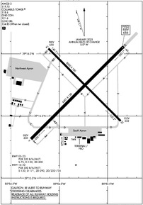
KBAK Airport Diagram
VFR Chart of KBAK
Sectional Charts at SkyVector.com
IFR Chart of KBAK
Enroute Charts at SkyVector.com
Location Information for KBAK
Coordinates: N39°15.71' / W85°53.78'Located 03 miles N of Columbus, Indiana on 2000 acres of land. View all Airports in Indiana.
Surveyed Elevation is 656 feet MSL.
Operations Data
|
|
Airport Communications
| AWOS-3: | 119.75 Tel. 812-376-7584 |
|---|---|
| COLUMBUS TOWER: | 118.6 |
| COLUMBUS GROUND: | 121.6 |
| INDIANAPOLIS APPROACH: | 134.85 317.8 |
| INDIANAPOLIS DEPARTURE: | 134.85 317.8 |
| CLEARANCE DELIVERY: | 134.85 ;CTC APCH CTL |
| UNICOM: | 122.950 |
| CTAF: | 118.600 |
| AWOS-3 at OVO (18.8 SE): | 120.625 812-346-5041 |
| ASOS at GEZ (19.5 N): | 121.55 317-398-0246 |
| AWOS-3 at SER (20.6 S): | 119.425 812-522-4244 |
- CLEARANCE DELIVERY FREQUENCY 134.85 USED WHEN ATCT CLSD.
Nearby Navigation Aids
|
| ||||||||||||||||||||||||||||||||||||||||||||||||||||||||||||


Runway 05/23
RWY 05/23 NOT AVBL FOR PART 121/PART 380 OPS WITH SKED PAX CARRYING OPS MORE THAN 9 PAX SEATS AND NON-SKED PAX CARRYING OPS MORE THAN 30 PAX SEATS. 90 DAY PPR FOR UNSKED ACR OPS GTR THAN 30 PAX SEATS - CALL AMGR. 812-376-2519 OR 379-9942. MIL MARKINGS CMSND. | ||
| Dimensions: | 6401 x 150 feet / 1951 x 46 meters | |
|---|---|---|
| Surface: | Concrete / Grooved in Excellent Condition | |
| Weight Limits: | S-75, D-130, ST-200
PCR VALUE: 320/R/A/W/T
| |
| Edge Lighting: | High Intensity | |
| Runway 05 | Runway 23 | |
| Coordinates: | N39°15.31' / W85°54.29' | N39°16.06' / W85°53.33' |
| Elevation: | 650.3 | 656.0 |
| Traffic Pattern: | Left | Left |
| Runway Heading: | 45° True | 225° True |
| Declared Distances: | TORA:6401 TODA:6401 ASDA:6401 LDA:6401 | TORA:6401 TODA:6401 ASDA:6401 LDA:6401 |
| Markings: | Precision Instrument in good condition. | Precision Instrument in good condition. |
| Glide Slope Indicator | P4L (3.00° Glide Path Angle) | P4L (3.00° Glide Path Angle) |
| Approach Lights: | MALSR 1,400 Foot Medium-intensity Approach Lighting System with runway alignment indicator lights. | |
| REIL: | Yes | |
| Obstacles: | 74 ft Tower 3040 ft from runway, 94 ft right of center | |
Runway 14/32
RWY 14/32 NOT AVBL FOR PART 121/PART 380 OPS WITH SKED PAX CARRYING OPS MORE THAN 9 PAX SEATS AND NON-SKED PAX CARRYING OPS MORE THAN 30 PAX SEATS. 90 DAY PPR FOR UNSKED ACR OPS GTR THAN 30 PAX SEATS - CALL AMGR. 812-376-2519 OR 379-9942. | ||
| Dimensions: | 5000 x 100 feet / 1524 x 30 meters | |
|---|---|---|
| Surface: | Concrete / Grooved in Excellent Condition | |
| Weight Limits: | S-120, D-171, ST-290, DT-735
PCR VALUE: 300/R/A/W/T
| |
| Edge Lighting: | Medium Intensity | |
| Runway 14 | Runway 32 | |
| Coordinates: | N39°16.04' / W85°54.11' | N39°15.46' / W85°53.36' |
| Elevation: | 654.5 | 651.5 |
| Traffic Pattern: | Left | Left |
| Runway Heading: | 135° True | 315° True |
| Declared Distances: | TORA:5000 TODA:5000 ASDA:5000 LDA:5000 | TORA:5000 TODA:5000 ASDA:5000 LDA:5000 |
| Markings: | Non-Precision Instrument in good condition. | Non-Precision Instrument in good condition. |
| Glide Slope Indicator | P4L (3.00° Glide Path Angle) | P4L (3.00° Glide Path Angle) |
| REIL: | Yes | Yes |
Services Available
| Fuel: | 100LL (blue), Jet-A |
|---|---|
| Transient Storage: | Hangars,Tiedowns |
| Airframe Repair: | MAJOR |
| Engine Repair: | MAJOR |
| Bottled Oxygen: | NOT AVAILABLE |
| Bulk Oxygen: | HIGH |
| Other Services: | AIR FREIGHT SERVICES,AVIONICS,CHARTER SERVICE,PILOT INSTRUCTION,AIRCRAFT RENTAL,AIRCRAFT SALES,ANNUAL SURVEYING |
Ownership Information
| Ownership: | Publicly owned | |
|---|---|---|
| Owner: | CITY OF COLUMBUS | |
| 4770 RAY BOLL BLVD | ||
| COLUMBUS, IN 47203 | ||
| 812-376-2519 | ||
| Manager: | BRIAN PAYNE | |
| 4770 RAY BOLL BLVD | ||
| COLUMBUS, IN 47203 | ||
| 812-376-2519 | 812-379-9942 | |
Other Remarks
- SAWRS AVBL.
- BIRDS ON & INVOF ARPT; HVY ACT AUG & SEP.
- FICONS NOT MNTD 1700-0600.
- ACFT SVCS - UNICOM.
- WHEN ATCT CLSD ACTVT MALSR RWY 23; REIL RWY 05, 14 & 32; HIRL RWY 05/23; MIRL RWY 14/32 - CTAF. PAPI RWY 5, 14, 23 & 32 ON CONSLY.
Weather Minimums


Instrument Approach Procedure (IAP) Charts


Nearby Airports with Instrument Procedures
| ID | Name | Heading / Distance | ||
|---|---|---|---|---|
 |
I34 | Greensburg Municipal Airport | 078° | 17.6 |
|
KOVO | North Vernon Airport | 133° | 18.8 |
|
KGEZ | Shelbyville Municipal Airport | 012° | 19.7 |
|
KSER | Freeman Municipal Airport | 181° | 20.3 |
|
KHFY | Indy South Greenwood Airport | 337° | 23.7 |
 |
8A4 | Indianapolis Downtown Heliport | 338° | 32.4 |
|
KIND | Indianapolis International Airport | 326° | 33.0 |
|
KBMG | Monroe County Airport | 258° | 34.3 |
|
KMQJ | Indianapolis Regional Airport | 359° | 34.8 |
|
KBFR | Virgil I Grissom Municipal Airport | 225° | 36.0 |
|
KIMS | Madison Regional Airport | 146° | 36.2 |
|
KEYE | Eagle Creek Airpark Airport | 331° | 38.8 |
Airport Images
, 1700'")
By: 2flaps
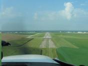
By: Pbergen


Comments
KBAK tower/ground, 100LL
KBAK tower is friendly and helpful. Not usually overworked but there can be occasional volume of military training or helicopters. Pilots should anticipate being given a non-standard-pattern entry, and being asked to report upon reaching, e.g., midfield, or a 3-mile base. There is a separate ground frequency but often the tower frequency is covering all calls. Self-serve fuel when working is fairly priced and attracts traffic, but has been inop much of 2023, if planning to stop for that price it may be advisible to call first. Ramp personnel / fuel truck very friendly and helpful. Very easy airport to get in/out of, but be careful of the many military areas nearby.