Login
Register


OVO
North Vernon Airport
Official FAA Data Effective 2026-02-19 0901Z
Chart Supplement

VFR Chart of KOVO
Sectional Charts at SkyVector.com
IFR Chart of KOVO
Enroute Charts at SkyVector.com
Location Information for KOVO
Coordinates: N39°2.72' / W85°36.34'Located 02 miles NE of North Vernon, Indiana on 803 acres of land. View all Airports in Indiana.
Surveyed Elevation is 757 feet MSL.
Operations Data
|
|
Airport Communications
| AWOS-3: | 120.625 Tel. 812-346-5041 |
|---|---|
| INDIANAPOLIS APPROACH: | 134.85 317.8 |
| INDIANAPOLIS DEPARTURE: | 134.85 317.8 |
| CTAF: | 122.700 |
| UNICOM: | 122.700 |
| AWOS-3 at SER (15.8 SW): | 119.425 812-522-4244 |
| AWOS-3 at IMS (18.4 S): | 119.175 812-866-1798 |
| AWOS-3 at BAK (18.8 NW): | 119.75 812-376-7584 |
- COMMUNICATIONS PRVDD BY TERRE HAUTE RADIO ON FREQ 122.3 (OSGOOD RCO).
Nearby Navigation Aids
|
| ||||||||||||||||||||||||||||||||||||||||||||||||||||||||||||


Runway 05/23
| Dimensions: | 5002 x 75 feet / 1525 x 23 meters | |
|---|---|---|
| Surface: | Asphalt in Excellent Condition | |
| Weight Limits: | S-100, D-135, ST-230 | |
| Edge Lighting: | Medium Intensity | |
| Runway 05 | Runway 23 | |
| Coordinates: | N39°2.42' / W85°36.63' | N39°2.97' / W85°35.85' |
| Elevation: | 757.2 | 754.8 |
| Traffic Pattern: | Left | Left |
| Runway Heading: | 48° True | 228° True |
| Markings: | Non-Precision Instrument in good condition. | Non-Precision Instrument in good condition. |
| Glide Slope Indicator | P2L (3.00° Glide Path Angle) | P2L (3.00° Glide Path Angle) |
| Obstacles: | ft Road ft from runway 10 FT CROPS 125 FT R OF RWY END CNTRLN. |
ft Road ft from runway 10 FT CROPS 80 FT L OF RWY END CNTRLN. |
Runway 15/33
| Dimensions: | 2730 x 50 feet / 832 x 15 meters | |
|---|---|---|
| Surface: | Asphalt in Excellent Condition | |
| Weight Limits: | S-4 | |
| Edge Lighting: | Medium Intensity | |
| Runway 15 | Runway 33 | |
| Coordinates: | N39°2.97' / W85°36.65' | N39°2.57' / W85°36.38' |
| Elevation: | 751.9 | 756.4 |
| Traffic Pattern: | Left | Left |
| Runway Heading: | 153° True | 333° True |
| Markings: | Basic in good condition. | Basic in fair condition. |
| Glide Slope Indicator | P2L (3.50° Glide Path Angle) | |
| Obstacles: | 14 ft Road 375 ft from runway, 140 ft right of center 10 FT CROPS 60 FT L OF RWY END CNTRLN. |
55 ft Trees 1120 ft from runway, 205 ft right of center 10 FT CROPS 60 FT L & R OF RWY END CNTRLN. |
Services Available
| Fuel: | 100LL (blue), Jet-A |
|---|---|
| Transient Storage: | Hangars,Tiedowns |
| Airframe Repair: | MAJOR |
| Engine Repair: | MAJOR |
| Bottled Oxygen: | NONE |
| Bulk Oxygen: | NONE |
| Other Services: | PILOT INSTRUCTION,AIRCRAFT RENTAL |
Ownership Information
| Ownership: | Publicly owned | |
|---|---|---|
| Owner: | NORTH VERNON BOAC | |
| 645 E CO RD 450N | ||
| NORTH VERNON, IN 47265 | ||
| 812-346-5223 | ||
| Manager: | RYAN A. CURRY | |
| 645 E CO RD 450N | ||
| NORTH VERNON, IN 47265 | ||
| 812-346-5223 | ||
Other Remarks
- 24 HR SELF SERVICE FUEL AVBL.
- FOR CD CTC INDIANAPOLIS APCH AT 317-227-5743.
- ACTVT PAPI RWY 05 & 23: MIRL RWY 05/23 - CTAF.
Weather Minimums

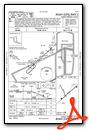
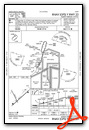
Instrument Approach Procedure (IAP) Charts

Nearby Airports with Instrument Procedures
| ID | Name | Heading / Distance | ||
|---|---|---|---|---|
 |
KSER | Freeman Municipal Airport | 243° | 16.0 |
|
I34 | Greensburg Municipal Airport | 012° | 16.9 |
|
KIMS | Madison Regional Airport | 158° | 18.3 |
|
KBAK | Columbus Municipal Airport | 313° | 18.8 |
|
KGEZ | Shelbyville Municipal Airport | 344° | 33.5 |
|
I67 | Cincinnati West Airport | 071° | 40.9 |
|
KBFR | Virgil I Grissom Municipal Airport | 252° | 41.2 |
|
KJVY | Clark Regional Airport | 188° | 41.2 |
|
KHFY | Indy South Greenwood Airport | 327° | 41.5 |
|
KCVG | Cincinnati/Northern Kentucky International Airport | 089° | 43.8 |
|
KCEV | Mettel Field Airport | 029° | 44.9 |
|
KOXD | Miami University Airport | 054° | 47.1 |
Airport Images
Do you have a recent image of this airport? Upload it here!


