Login
Register


02G
Columbiana County Airport
Official FAA Data Effective 2026-02-19 0901Z
Chart Supplement

VFR Chart of 02G
Sectional Charts at SkyVector.com
IFR Chart of 02G
Enroute Charts at SkyVector.com
Location Information for 02G
Coordinates: N40°40.40' / W80°38.49'Located 04 miles NW of East Liverpool, Ohio on 142 acres of land. View all Airports in Ohio.
Surveyed Elevation is 1160 feet MSL.
Operations Data
|
|
Airport Communications
| PITTSBURGH APPROACH: | 124.75 338.2 |
|---|---|
| PITTSBURGH DEPARTURE: | 124.75 338.2 |
| CLASS B: | 124.75 338.2 |
| UNICOM: | 123.000 |
| CTAF: | 123.000 |
| ATIS at BVI (12.8 NE): | 118.35 |
| AWOS-3PT at BVI (12.8 NE): | 118.35 724-843-1024 |
| AWOS-3 at 2G2 (18.7 S): | 121.625 740-275-4862 |
Nearby Navigation Aids
|
| ||||||||||||||||||||||||||||||||||||||||||||||||||||||||||||


Runway 07/25
| Dimensions: | 3503 x 75 feet / 1068 x 23 meters | |
|---|---|---|
| Surface: | Asphalt in Good Condition | |
| Weight Limits: | S-12 | |
| Edge Lighting: | Medium Intensity | |
| Runway 07 | Runway 25 | |
| Coordinates: | N40°40.26' / W80°38.82' | N40°40.54' / W80°38.16' |
| Elevation: | 1142.7 | 1160.3 |
| Traffic Pattern: | Left | Left |
| Runway Heading: | 61° True | 241° True |
| Markings: | Non-Precision Instrument in good condition. | Non-Precision Instrument in good condition. |
| Glide Slope Indicator | P4L (3.00° Glide Path Angle) | |
| REIL: | Yes | Yes |
| Obstacles: | 8 ft Tree 321 ft from runway, 58 ft right of center | 60 ft Trees 1325 ft from runway, 105 ft left of center |
Services Available
| Fuel: | 100LL (blue) |
|---|---|
| Transient Storage: | Tiedowns ROPES NOT PRVDD. |
| Airframe Repair: | NONE |
| Engine Repair: | NONE |
| Bottled Oxygen: | NONE |
| Bulk Oxygen: | NONE |
Ownership Information
| Ownership: | Publicly owned | |
|---|---|---|
| Owner: | COLUMBIANA CO ARPT AUTH | |
| PO BOX 81 | ||
| EAST LIVERPOOL, OH 43920-5081 | ||
| 330-397-5769 | ||
| Manager: | JAMES PUSATERI | |
| PO BOX 81 | ||
| EAST LIVERPOOL, OH 43920-5081 | ||
| 330-397-5769 | ||
Other Remarks
- LGTD OBSTN HI TENSION LINE 1.5 NM NW.
- DEER, BIRDS, & OTR WILDLIFE ON & INVOF ARPT.
- FOR CD CTC PITTSBURGH APCH AT 412-472-5591.
- 0LL 100LL AVBL H24 SELF SVC VIA CREDIT CARD.
- ACTVT REIL RWY 07 & 25; PAPI RWY 25; MIRL RWY 07/25 - CTAF.
Weather Minimums

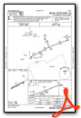
Instrument Approach Procedure (IAP) Charts
Nearby Airports with Instrument Procedures
| ID | Name | Heading / Distance | ||
|---|---|---|---|---|
 |
KBVI | Beaver County Airport | 062° | 12.9 |
|
4G4 | Youngstown Elser Metro Airport | 354° | 17.4 |
|
2G2 | Geary A Bates/Jefferson County Airpark Airport | 188° | 19.0 |
|
38D | Salem Airpark Airport | 328° | 19.3 |
|
KTSO | Carroll County/Tolson Airport | 251° | 21.0 |
|
3G6 | Tri-City Airport | 310° | 21.5 |
|
KPIT | Pittsburgh International Airport | 120° | 21.6 |
|
KPJC | Zelienople Municipal Airport | 070° | 23.2 |
|
KUCP | New Castle Municipal Airport | 026° | 23.5 |
|
KHLG | Wheeling Ohio County Airport | 180° | 29.9 |
|
8G6 | Harrison County Airport | 213° | 31.1 |
|
KBTP | Pittsburgh/Butler Regional Airport | 078° | 32.1 |
Airport Images

By: btracy62


