Login
Register


UCP
New Castle Municipal Airport
Official FAA Data Effective 2026-02-19 0901Z
Chart Supplement

VFR Chart of KUCP
Sectional Charts at SkyVector.com
IFR Chart of KUCP
Enroute Charts at SkyVector.com
Location Information for KUCP
Coordinates: N41°1.52' / W80°24.80'Located 04 miles NW of New Castle, Pennsylvania on 320 acres of land. View all Airports in Pennsylvania.
Surveyed Elevation is 1072 feet MSL.
Operations Data
|
|
Airport Communications
| AWOS-3PT: | 124.175 Tel. (724) 652-4184 |
|---|---|
| YOUNGSTOWN APPROACH: | 133.95 322.3 |
| YOUNGSTOWN DEPARTURE: | 133.95 322.3 |
| UNICOM: | 123.000 |
| CTAF: | 123.000 |
| AWOS-3PT at BVI (15.2 S): | 118.35 724-843-1024 |
| ATIS at BVI (15.2 S): | 118.35 |
| AWOS-3PT at PJC (17.6 SE): | 118.45 724-452-5304 |
- APCH/DEP SVC PRVDD BY CLEVELAND ARTCC (ZOB) ON FREQS 126.725/291.65(DUBOIS RCAG) WHEN YOUNGSTOWN APCH CTL CLSD.
Nearby Navigation Aids
|
| ||||||||||||||||||||||||||||||||||||||||||||||||||||||||||||


Runway 05/23
| Dimensions: | 3995 x 75 feet / 1218 x 23 meters | |
|---|---|---|
| Surface: | Asphalt in Good Condition | |
| Weight Limits: | S-12 | |
| Edge Lighting: | Medium Intensity | |
| Runway 05 | Runway 23 | |
| Coordinates: | N41°1.35' / W80°25.09' | N41°1.85' / W80°24.53' |
| Elevation: | 1022.0 | 1007.0 |
| Traffic Pattern: | Left | Left |
| Runway Heading: | 39° True | 219° True |
| Markings: | Non-Precision Instrument in fair condition. | Non-Precision Instrument in good condition. |
| Glide Slope Indicator | P4L (3.00° Glide Path Angle) | P4L (3.00° Glide Path Angle) |
| REIL: | Yes | Yes |
| Obstacles: | 44 ft Trees 663 ft from runway, 309 ft right of center | 47 ft Trees 563 ft from runway, 284 ft right of center 20 FT TREES: 30 FT FM RWY END, 205 FT RIGHT. |
Runway 13/31
| Dimensions: | 2855 x 100 feet / 870 x 30 meters | |
|---|---|---|
| Surface: | Asphalt in Fair Condition | |
| Weight Limits: | S-12 | |
| Runway 13 | Runway 31 | |
| Coordinates: | N41°1.52' / W80°25.06' | N41°1.29' / W80°24.52' |
| Elevation: | 1016.3 | 1072.3 |
| Traffic Pattern: | Left | Left |
| Runway Heading: | 118° True | 298° True |
| Displaced Threshold: | 108 Feet | |
| Markings: | Basic in good condition. | Basic in good condition. |
| Glide Slope Indicator | P2L (3.00° Glide Path Angle) | |
Services Available
| Fuel: | 100LL (blue) |
|---|---|
| Transient Storage: | Hangars,Tiedowns |
| Airframe Repair: | MAJOR |
| Engine Repair: | MAJOR |
| Bottled Oxygen: | NONE |
| Bulk Oxygen: | NONE |
| Other Services: | PILOT INSTRUCTION,AIRCRAFT RENTAL,AIRCRAFT SALES |
Ownership Information
| Ownership: | Publicly owned | |
|---|---|---|
| Owner: | LAWRENCE CO. AIRPORT AUTHORITY | |
| 406 FRANK FARONE DRIVE | ||
| NEW CASTLE, PA 16101 | ||
| (724) 652-5546 | ||
| Manager: | JAMES FARRIS, JR. | |
| 406 FRANK FARONE DRIVE | ||
| NEW CASTLE, PA 16101 | ||
| (724) 651-2100 | ||
Other Remarks
- DEER ON AND INVOF AIRPORT.
- FOR CD CTC YOUNGSTOWN APCH AT 330-856-4806, WHEN APCH CLSD CTC CLEVELAND ARTCC AT 440-774-0234.
- ACTVT REILS RWY 05 & 23; PAPI RWY 05, 13, 23; MIRL RWY 05/23 - CTAF.
Weather Minimums

Instrument Approach Procedure (IAP) Charts

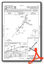
Nearby Airports with Instrument Procedures
| ID | Name | Heading / Distance | ||
|---|---|---|---|---|
 |
4G4 | Youngstown Elser Metro Airport | 252° | 12.6 |
|
29D | Grove City Airport | 056° | 13.3 |
|
KBVI | Beaver County Airport | 176° | 15.2 |
|
KPJC | Zelienople Municipal Airport | 139° | 17.6 |
|
KYNG | Youngstown/Warren Regional Airport | 319° | 18.6 |
|
38D | Salem Airpark Airport | 257° | 20.9 |
|
02G | Columbiana County Airport | 206° | 23.5 |
|
4G1 | Greenville Municipal Airport | 002° | 25.3 |
|
KBTP | Pittsburgh/Butler Regional Airport | 125° | 25.8 |
|
3G6 | Tri-City Airport | 255° | 27.6 |
|
KFKL | Venango Regional Airport | 049° | 32.7 |
|
KPIT | Pittsburgh International Airport | 165° | 33.1 |
Airport Images
Do you have a recent image of this airport? Upload it here!


