Login
Register


CCO
Newnan Coweta County Airport
Official FAA Data Effective 2026-01-22 0901Z
Chart Supplement

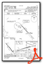
VFR Chart of KCCO
Sectional Charts at SkyVector.com
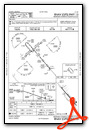
IFR Chart of KCCO
Enroute Charts at SkyVector.com
Location Information for KCCO
Coordinates: N33°18.69' / W84°46.19'Located 04 miles S of Atlanta, Georgia on 270 acres of land. View all Airports in Georgia.
Surveyed Elevation is 970 feet MSL.
Operations Data
|
|
Airport Communications
| AWOS-3PT: | 118.975 Tel. 770-254-1617 |
|---|---|
| ATLANTA APPROACH: | 119.8 354.125 |
| ATLANTA DEPARTURE: | 119.8 354.125 |
| UNICOM: | 122.700 |
| CTAF: | 122.700 |
| ASOS at FFC (10.3 E): | 118.525 770-487-1610 |
| AWOS-3 at HMP (22.5 E): | 124.825 770-707-1719 |
| AWOS-3PT at 5A9 (22.8 S): | 118.35 706-655-2005 |
Nearby Navigation Aids
|
| ||||||||||||||||||||||||||||||||||||||||||||||||||||||||||||


Runway 15/33
| Dimensions: | 5500 x 100 feet / 1676 x 30 meters | |
|---|---|---|
| Surface: | Asphalt in Fair Condition | |
| Weight Limits: | S-26, D-37 | |
| Edge Lighting: | High Intensity | |
| Runway 15 | Runway 33 | |
| Coordinates: | N33°19.04' / W84°46.54' | N33°18.35' / W84°45.83' |
| Elevation: | 970.2 | 928.9 |
| Traffic Pattern: | Left | Left |
| Runway Heading: | 139° True | 319° True |
| Markings: | Precision Instrument in good condition. | Precision Instrument in good condition. |
| Glide Slope Indicator | P4L (3.00° Glide Path Angle) | P4L (3.00° Glide Path Angle) |
| Approach Lights: | MALSF 1,400 Foot Medium-intensity Approach Lighting System with sequenced flashers. | |
| Obstacles: | 64 ft Trees 927 ft from runway, 582 ft left of center 15 FT POWER POLES, 139 FT FROM EOR, 355 FT RIGHT OF CNTRLN. |
30 ft Trees 201 ft from runway, 345 ft right of center 30 FT TREES, 264 FT RIGHT OF CNTRLN AT RWY END OUT TO 200 FT FM RWY END. |
Services Available
| Fuel: | 100LL (blue), Jet A+ |
|---|---|
| Transient Storage: | Tiedowns |
| Airframe Repair: | MAJOR |
| Engine Repair: | MAJOR |
| Bottled Oxygen: | LOW |
| Bulk Oxygen: | NONE |
| Other Services: | AIR AMBULANCE SERVICES,AVIONICS,PILOT INSTRUCTION,AIRCRAFT RENTAL |
Ownership Information
| Ownership: | Publicly owned | |
|---|---|---|
| Owner: | NEWNAN & COWETA CO ARPT AUTH | |
| 115 AIRPORT ROAD, BOX 2 | ||
| NEWNAN, GA 30263 | ||
| 770-254-8102 | ||
| Manager: | CALVIN WALKER | |
| 115 AIRPORT ROAD, BOX 2 | ||
| NEWNAN, GA 30263 | ||
| 770-254-8102 | ||
Other Remarks
- GCO AVBL ON FREQ 121.725 THRU FLT SVCS.
- WILDLIFE INVOF ARPT.
- EXTENSIVE FLIGHT TRAINING ON AND INVOF AIRPORT
- FOR CD CTC ATLANTA APCH AT 678-364-6131.
- ACTVT MALSF RWY 33; HIRL RWY 15/33 - CTAF.
Weather Minimums

Standard Terminal Arrival (STAR) Charts
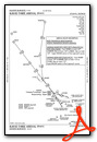
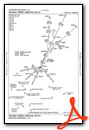
Instrument Approach Procedure (IAP) Charts

Nearby Airports with Instrument Procedures
| ID | Name | Heading / Distance | ||
|---|---|---|---|---|
 |
KFFC | Atlanta Regional Falcon Field Airport | 074° | 10.3 |
|
KHMP | Atlanta Speedway Airport | 077° | 22.5 |
|
KLGC | Lagrange/Callaway Airport | 220° | 23.7 |
|
6A2 | Griffin-Spalding County Airport | 101° | 25.4 |
|
KATL | Hartsfield/Jackson Atlanta International Airport | 041° | 26.0 |
|
KCTJ | West Georgia Regional/O V Gray Field Airport | 315° | 27.1 |
|
KPIM | Harris County Airport | 191° | 28.8 |
|
KFTY | Fulton County Exec/Charlie Brown Field Airport | 023° | 30.7 |
|
KOPN | Thomaston-Upson County Airport | 129° | 33.2 |
|
KPUJ | Paulding Northwest Atlanta Airport | 346° | 37.0 |
|
7A3 | Lanett Regional Airport | 217° | 37.9 |
|
KMGE | Dobbins Arb Airport | 019° | 38.3 |
Fuel Providers

Airport Images
Do you have a recent image of this airport? Upload it here!


Comments
Fuel price for self serve is
Fuel price for self serve is not 3.90 as of 5/18/2018, it is $4.15
KCCO location
The location of Newnan Coweta County Airport (KCCO) as listed in the section with the coordinates IS NOT "04 miles south of Atlanta, GA..." It is actually 25 miles SW of KATL/ATL VORTAC which is south of downtown Atlanta, GA. KCCO is, however, approximately 3-4 miles south of NEWNAN, GA. Suggest updating the data base.