Login
Register


Y83
Sandusky City Airport
Official FAA Data Effective 2026-02-19 0901Z
Chart Supplement

VFR Chart of Y83
Sectional Charts at SkyVector.com
IFR Chart of Y83
Enroute Charts at SkyVector.com
Location Information for Y83
Coordinates: N43°27.34' / W82°50.51'Located 03 miles N of Sandusky, Michigan on 63 acres of land. View all Airports in Michigan.
Surveyed Elevation is 776 feet MSL.
Operations Data
|
|
Airport Communications
| UNICOM: | 122.800 |
|---|---|
| CTAF: | 122.800 |
| AWOS-3P at BAX (20.3 N): | 118.6 989-269-4137 |
| AWOS-3P at CFS (26.2 W): | 119.275 989-672-4182 |
| AWOS-3P at D95 (30.0 SW): | 134.050 810-664-5038 |
- APCH/DEP SVC PRVDD BY CLEVELAND ARTCC (ZOB) ON FREQS 127.7/290.425 (FREELAND RCAG).
Nearby Navigation Aids
|
| ||||||||||||||||||||||||||||||||||||||||||


Runway 10/28
| Dimensions: | 3499 x 75 feet / 1066 x 23 meters | |
|---|---|---|
| Surface: | Asphalt in Excellent Condition | |
| Weight Limits: | S-16 | |
| Edge Lighting: | Medium Intensity | |
| Runway 10 | Runway 28 | |
| Coordinates: | N43°27.42' / W82°50.85' | N43°27.43' / W82°50.06' |
| Elevation: | 776.3 | 774.4 |
| Traffic Pattern: | Left | Left |
| Runway Heading: | 89° True | 269° True |
| Markings: | Non-Precision Instrument in good condition. | Non-Precision Instrument in good condition. |
| Glide Slope Indicator | P2L (3.00° Glide Path Angle) | P2L (3.00° Glide Path Angle) |
| REIL: | Yes | |
Runway 18/36
| Dimensions: | 2271 x 153 feet / 692 x 47 meters | |
|---|---|---|
| Surface: | Turf in Good Condition | |
| Runway 18 | Runway 36 | |
| Coordinates: | N43°27.39' / W82°50.58' | N43°27.02' / W82°50.58' |
| Elevation: | 774.4 | 772.8 |
| Runway Heading: | 179° True | 359° True |
| Displaced Threshold: | 374 Feet | |
| Obstacles: | 17 ft Road 58 ft from runway, 125 ft right of center APCH RATIO 6:1 TO DTHR OVR 63 FT TREE, 380 FT DIST, 150 FT R. |
|
Services Available
| Fuel: | 100LL (blue) |
|---|---|
| Transient Storage: | Hangars,Tiedowns |
| Airframe Repair: | MAJOR |
| Engine Repair: | MAJOR |
| Bottled Oxygen: | NONE |
| Bulk Oxygen: | NONE |
Ownership Information
| Ownership: | Publicly owned | |
|---|---|---|
| Owner: | CITY OF SANDUSKY | |
| 26 W SPEAKER ST | ||
| SANDUSKY, MI 48471-1299 | ||
| 810-648-4444 | ||
| Manager: | DON JOHNSTON | |
| CITY HALL, 26 W SPEAKER ST | ||
| SANDUSKY, MI 48471-1299 | ||
| 810-414-3009 | ||
Other Remarks
- +3 FT EMBANKMENT, 50 FT FM RWY 36 THR; -10 FT DITCH, 100 FT EAST OF RWY 18/36.
- DEER & LRG BIRDS ON & INVOF ARPT.
- FOR CD CTC CLEVELAND ARTCC AT 440-774-0224/0490.
- FOR AFT HRS ACES TO TRML BLDG CALL AMGR.
- 3 FT YELLOW CONES.
- 3 FT YELLOW CONES.
- ACTVT MIRL RWY 10/28 - CTAF.
Weather Minimums

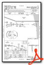
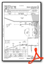
Instrument Approach Procedure (IAP) Charts
Nearby Airports with Instrument Procedures
| ID | Name | Heading / Distance | ||
|---|---|---|---|---|
 |
77G | Marlette Township Airport | 231° | 13.9 |
|
KBAX | Huron County Memorial Airport | 342° | 20.5 |
|
KCFS | Tuscola Area Airport | 270° | 26.4 |
|
D95 | Dupont/Lapeer Airport | 219° | 30.0 |
|
KPHN | St Clair County International Airport | 157° | 35.4 |
|
CYZR | Sarnia Chris Hadfield Airport | 139° | 36.0 |
|
D98 | Romeo State Airport | 188° | 40.0 |
|
57D | Ray Community Airport | 182° | 43.2 |
|
KHYX | Saginaw County/H W Browne Airport | 268° | 44.6 |
|
3CM | James Clements Municipal Airport | 277° | 46.3 |
|
KFNT | Bishop International Airport | 233° | 49.3 |
|
KMTC | Selfridge Angb Airport | 179° | 50.5 |
Airport Images

By: sunmanav8


Comments
Looking forward to using
Looking forward to using SkyVector for the future of aviation