Login
Register


8W2
New Market Airport
Official FAA Data Effective 2026-02-19 0901Z
Chart Supplement

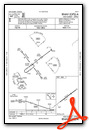
VFR Chart of 8W2
Sectional Charts at SkyVector.com
IFR Chart of 8W2
Enroute Charts at SkyVector.com
Location Information for 8W2
Coordinates: N38°39.36' / W78°42.51'Located 02 miles W of New Market, Virginia on 44 acres of land. View all Airports in Virginia.
Estimated Elevation is 962 feet MSL.
Operations Data
|
|
Airport Communications
| AWOS-3: | 118.175 Tel. 540-740-3801 |
|---|---|
| UNICOM: | 122.800 |
| CTAF: | 122.800 |
| AWOS-3 at LUA (9.8 E): | 118.275 540-743-1148 |
| AWOS-3 at VBW (21.0 SW): | 119.55 540-828-2076 |
| AWOS-3 at SHD (25.4 S): | 124.925 540-234-0110 |
- APCH/DEP SVC PRVDD BY WASHINGTON ARTCC ON FREQS 133.2/282.2 (BUCKS ELBOW RCAG).
Nearby Navigation Aids
|
| ||||||||||||||||||||||||||||||||||||||||||||||||||||||||||||


Runway 06/24
| Dimensions: | 2920 x 60 feet / 890 x 18 meters | |
|---|---|---|
| Surface: | Asphalt in Excellent Condition | |
| Edge Lighting: | Non-Standard NSTD LIRL; THLD LGTS ONE FIXTURE EACH SIDE. RY 06 LGTD THLD RELOCATED 100 FT & RY 24 LGTD THLD RELOCATED 930 FT FOR NGT OPNS; 2020 FT RY 06/24 LGTD AT NGT. NO RY END LGTS RY 24. | |
| Runway 06 | Runway 24 | |
| Coordinates: | N38°39.21' / W78°42.75' | N38°39.50' / W78°42.27' |
| Elevation: | 962.2 | 962.3 |
| Traffic Pattern: | Right | Left |
| Runway Heading: | 53° True | 233° True |
| Displaced Threshold: | 918 Feet | |
| Markings: | Basic in good condition. | Basic in good condition. |
| Obstacles: | RIDGE & TREES PERPINDICULAR TO RWY 06; 225 FT LEFT OF CNTRLN & APRXLY 1300 FT FROM THLD. |
15 ft Road 201 ft from runway, 100 ft left of center CTLG OBSTN EXCEEDS 45 DEG SLP; CLNC SLP 34:1 TO DTHR. RY 24, 5 FT FENCE 110 FT FM THLD 0B, 15 FT ROAD 115 FT FM THLD 0B, POLE 90 FT FM THR 100 FT R, 23 FT PLINE 114 FT FM THLD 117 FT L. |
Services Available
| Fuel: | 100LL (blue) |
|---|---|
| Transient Storage: | Hangars,Tiedowns |
| Airframe Repair: | MAJOR BLN RPR STN; ACFT RPRS AVBL, BUT NOT FULL-TIME. |
| Engine Repair: | MAJOR PWR PLANT RPRS AVBL, BUT NOT FULL-TIME. |
| Bottled Oxygen: | NONE |
| Bulk Oxygen: | NONE |
| Other Services: | PILOT INSTRUCTION,PARACHUTE JUMP ACTIVITY |
Ownership Information
| Ownership: | Privately Owned | |
|---|---|---|
| Owner: | ROBERT THOMAS | |
| PO BOX 762 | ||
| MIDDLEBURG, VA 20118 | ||
| (703) 898-1157 | ||
| Manager: | ROBERT THOMAS | |
| PO BOX 762 | ||
| MIDDLEBURG, VA 20118 | ||
| 703-327-0444 | ||
Other Remarks
- DEER AND BIRDS ON & INVOF RY.
- FOR CD CTC WASHINGTON ARTCC AT 703-771-3587.
- HOT AIR BALLOONS WEEKENDS EARLY MORNING & LATE AFTERNOON.
- APRXLY 1000 FT N OF RY, 200 FT RIDGE/TREES PARALLEL RY.
- ARRIVING PILOTS SHOULD USE CAUTION. SKYDIVING OPERATIONS WITHIN 2NM OF THE AIRPORT FROM 0800-SUNSET EVERY WEEKEND AND OCCASIONALLY DURING THE WEEK.
- 0LL 24 HR CREDIT CARD SVC
Weather Minimums

Instrument Approach Procedure (IAP) Charts

Nearby Airports with Instrument Procedures
| ID | Name | Heading / Distance | ||
|---|---|---|---|---|
 |
KLUA | Luray Caverns Airport | 086° | 9.8 |
|
KVBW | Bridgewater Air Park Airport | 214° | 21.0 |
|
KSHD | Shenandoah Valley Regional Airport | 200° | 25.1 |
|
KFRR | Front Royal-Warren County Airport | 053° | 26.5 |
|
W99 | Grant County Airport | 314° | 28.9 |
|
KCHO | Charlottesville-Albemarle Airport | 158° | 33.2 |
|
W13 | Eagle's Nest Airport | 197° | 36.4 |
|
KOKV | Winchester Regional Airport | 041° | 39.4 |
|
KGVE | Gordonsville Municipal Airport | 139° | 39.4 |
|
KOMH | Orange County Airport | 127° | 39.7 |
|
KCJR | Culpeper Regional Airport | 100° | 40.7 |
|
KHWY | Warrenton/Fauquier Airport | 094° | 47.1 |
Airport Images

By: Big Orange Bird

By: Big Orange Bird


