Login
Register


TKV
Tomahawk Regional Airport
Official FAA Data Effective 2026-02-19 0901Z
Chart Supplement

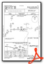
VFR Chart of KTKV
Sectional Charts at SkyVector.com
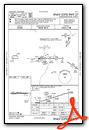
IFR Chart of KTKV
Enroute Charts at SkyVector.com
Location Information for KTKV
Coordinates: N45°28.16' / W89°48.29'Located 03 miles W of Tomahawk, Wisconsin on 280 acres of land. View all Airports in Wisconsin.
Surveyed Elevation is 1486 feet MSL.
Operations Data
|
|
Airport Communications
| AWOS-3: | 118.250 Tel. 715-453-5716 |
|---|---|
| UNICOM: | 122.800 |
| CTAF: | 122.800 |
| ASOS at RHI (16.7 NE): | 126.825 715-362-7980 |
| AWOS-3 at RRL (16.7 S): | 119.925 715-539-8422 |
| AWOS-3 at ARV (27.7 N): | 121.125 715-356-2417 |
- APCH/DEP SVC PRVDD BY MINNEAPOLIS ARTCC (RHINELANDER RCAG) ON FREQS 133.65/281.5.
Nearby Navigation Aids
|
| ||||||||||||||||||||||||||||||||||||||||||||||||


Runway 09/27
| Dimensions: | 4401 x 75 feet / 1341 x 23 meters | |
|---|---|---|
| Surface: | Asphalt in Good Condition | |
| Weight Limits: | S-26 | |
| Edge Lighting: | Medium Intensity | |
| Runway 09 | Runway 27 | |
| Coordinates: | N45°28.16' / W89°48.81' | N45°28.16' / W89°47.78' |
| Elevation: | 1467.6 | 1485.1 |
| Traffic Pattern: | Left | Left |
| Runway Heading: | 90° True | 270° True |
| Markings: | Non-Precision Instrument in good condition. | Non-Precision Instrument in good condition. |
| Glide Slope Indicator | P2L (3.00° Glide Path Angle) | P2L (3.00° Glide Path Angle) |
| REIL: | Yes | Yes |
Services Available
| Fuel: | 100LL (blue) |
|---|---|
| Transient Storage: | Hangars,Tiedowns |
| Airframe Repair: | MAJOR AIRFRAME & POWER PLANT REPAIRS BY PRIOR ARRANGEMENT CALL 715-453-2264 OR 453-3482. |
| Engine Repair: | MAJOR |
| Bottled Oxygen: | NONE |
| Bulk Oxygen: | NONE |
| Other Services: | PILOT INSTRUCTION |
Ownership Information
| Ownership: | Publicly owned | |
|---|---|---|
| Owner: | CITY OF TOMAHAWK | |
| CITY HALL | ||
| TOMAHAWK, WI 54487 | ||
| 715-453-4040 | ||
| Manager: | DAN ANDERSON | |
| 7350 S RIVER RD | ||
| TOMAHAWK, WI 54487 | ||
| 715-453-1874 | ||
Other Remarks
- DEER ON & INVOF ARPT.
- FOR CD CTC MINNEAPOLIS ARTCC AT 651-463-5588.
- 0LL FUEL AVBL 24 HRS WITH CREDIT CARD.
- MIRL RWY 09/27 PRESET TO LOW SS-SR, TO INCR INTST AND ACTVT REIL RWYS 09 & 27; MIRL RWY 09/27 - CTAF. PAPI RWY 09 & 27 OPRS CONSLY.
Weather Minimums


Instrument Approach Procedure (IAP) Charts
Nearby Airports with Instrument Procedures
| ID | Name | Heading / Distance | ||
|---|---|---|---|---|
 |
KRRL | Merrill Municipal Airport | 166° | 16.7 |
|
KRHI | Rhinelander/Oneida County Airport | 055° | 17.2 |
|
KARV | Lakeland/Noble F Lee Memorial Field Airport | 006° | 27.7 |
|
KPBH | Price County Airport | 299° | 29.0 |
|
KMDZ | Taylor County Airport | 223° | 30.5 |
|
KAUW | Wausau Downtown Airport | 166° | 33.5 |
|
KAIG | Langlade County Airport | 122° | 35.0 |
|
KEGV | Eagle River Union Airport | 038° | 35.8 |
|
Y55 | Crandon/Steve Conway Municipal Airport | 084° | 37.1 |
|
KPKF | Park Falls Municipal Airport | 318° | 39.1 |
|
D25 | Manitowish Waters Airport | 355° | 39.2 |
|
KCWA | Central Wisconsin Airport | 171° | 41.9 |
Airport Images
Do you have a recent image of this airport? Upload it here!


