Login
Register


LNL
Kings Land O' Lakes Airport
Official FAA Data Effective 2026-01-22 0901Z
Chart Supplement

VFR Chart of KLNL
Sectional Charts at SkyVector.com
IFR Chart of KLNL
Enroute Charts at SkyVector.com
Location Information for KLNL
Coordinates: N46°9.25' / W89°12.72'Located 01 miles SE of Land O' Lakes, Wisconsin on 496 acres of land. View all Airports in Wisconsin.
Surveyed Elevation is 1705 feet MSL.
Operations Data
|
|
Airport Communications
| AWOS-3: | 119.525 Tel. 715-547-6313 |
|---|---|
| CTAF: | 122.800 |
| UNICOM: | 122.800 |
| AWOS-3 at EGV (13.5 S): | 118.325 715-479-1465 |
| AWOS-3 at ARV (25.5 SW): | 121.125 715-356-2417 |
| AWOS-3PT at D25 (28.0 W): | 118.175 715-543-2004 |
- APCH/DEP SVC PRVDD BY MINNEAPOLIS ARTCC ON FREQS 133.65/281.5 (RHINELANDER RCAG).
Nearby Navigation Aids
|
| ||||||||||||||||||||||||||||||||||||||||||||||||


Runway 14/32
| Dimensions: | 4000 x 75 feet / 1219 x 23 meters | |
|---|---|---|
| Surface: | Asphalt in Excellent Condition | |
| Weight Limits: | S-12 | |
| Edge Lighting: | Medium Intensity | |
| Runway 14 | Runway 32 | |
| Coordinates: | N46°9.51' / W89°13.00' | N46°8.99' / W89°12.42' |
| Elevation: | 1705.6 | 1704.1 |
| Traffic Pattern: | Left | Left |
| Runway Heading: | 143° True | 323° True |
| Displaced Threshold: | 201 Feet | 399 Feet |
| Markings: | Non-Precision Instrument in good condition. | Non-Precision Instrument in good condition. |
| Glide Slope Indicator | P2L (4.00° Glide Path Angle) | P2L (3.00° Glide Path Angle) |
| REIL: | Yes | Yes |
| Obstacles: | 15 ft Road 200 ft from runway, 50 ft left of center APCH RATIO 20:1 TO DTHR. INTMT USE ROAD 0-200 FT FM RWY END 50-100 FT L. |
18 ft Road 200 ft from runway, 245 ft right of center ROAD 187 FT FM RWY END 250 FT R. |
Runway 05/23
CLSD NOV 15 - APR 15. | ||
| Dimensions: | 2577 x 130 feet / 785 x 40 meters | |
|---|---|---|
| Surface: | Turf in Fair Condition | |
| Runway 05 | Runway 23 | |
| Coordinates: | N46°9.10' / W89°12.96' | N46°9.38' / W89°12.49' |
| Elevation: | 1696.8 | 1704.4 |
| Runway Heading: | 50° True | 230° True |
| Displaced Threshold: | 589 Feet | |
| Obstacles: | 34 ft Trees 0 ft from runway, 100 ft right of center CTL OBSTN EXCEEDS 45 DEG SLOPE. |
53 ft Trees 285 ft from runway, 120 ft left of center APCH RATIO 16:1 TO DTHR; 94 FT TREES 1490 FT FM DTHR 135 L. |
Services Available
| Fuel: | 100LL (blue), Automotive Gasoline |
|---|---|
| Transient Storage: | Hangars,Tiedowns |
| Airframe Repair: | NONE |
| Engine Repair: | NONE |
| Bottled Oxygen: | NONE |
| Bulk Oxygen: | NONE |
Ownership Information
| Ownership: | Publicly owned | |
|---|---|---|
| Owner: | TOWN OF LAND O'LAKES | |
| BOX 660 | ||
| LAND O'LAKES, WI 54540 | ||
| 715-547-3255 | ||
| Manager: | BRUCE GARRISON | |
| PO BOX 327 | ||
| LAND O'LAKES, WI 54540 | ||
| 715-547-3337 | ||
Other Remarks
- DEER ON & INVOF ARPT.
- FOR CD CTC MINNEAPOLIS ARTCC AT 651-463-5588.
- APCH RATIO 20:1 TO DTHR.
- YELLOW CONES.
- YELLOW CONES.
- 0LL SELF SVC H24 WITH CREDIT CARD.
- ACTVT REIL RWY 14 & 32; PAPI RWY 14 & 32; MIRL RWY 14/32 - CTAF. SS-SR MIRL RWY 14/32 PRESET TO LOW INTST; INCR INTST - CTAF.
Weather Minimums


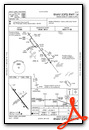
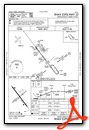
Instrument Approach Procedure (IAP) Charts
Nearby Airports with Instrument Procedures
| ID | Name | Heading / Distance | ||
|---|---|---|---|---|
 |
KEGV | Eagle River Union Airport | 190° | 13.5 |
|
KARV | Lakeland/Noble F Lee Memorial Field Airport | 238° | 25.6 |
|
D25 | Manitowish Waters Airport | 266° | 28.0 |
|
KRHI | Rhinelander/Oneida County Airport | 198° | 33.2 |
|
Y55 | Crandon/Steve Conway Municipal Airport | 162° | 39.7 |
|
KOGM | Ontonagon County/Schuster Field Airport | 351° | 42.0 |
|
KIWD | Gogebic/Iron County Airport | 300° | 44.3 |
|
KTKV | Tomahawk Regional Airport | 211° | 48.0 |
|
KIMT | Ford Airport | 113° | 50.1 |
|
KPKF | Park Falls Municipal Airport | 257° | 52.1 |
|
KPBH | Price County Airport | 242° | 56.6 |
|
KAIG | Langlade County Airport | 175° | 60.2 |
Airport Images
Do you have a recent image of this airport? Upload it here!


