Login
Register


EGV
Eagle River Union Airport
Official FAA Data Effective 2026-01-22 0901Z
Chart Supplement

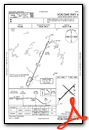
VFR Chart of KEGV
Sectional Charts at SkyVector.com
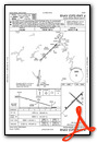
IFR Chart of KEGV
Enroute Charts at SkyVector.com
Location Information for KEGV
Coordinates: N45°55.94' / W89°16.10'Located 00 miles NW of Eagle River, Wisconsin on 588 acres of land. View all Airports in Wisconsin.
Surveyed Elevation is 1642 feet MSL.
Operations Data
|
|
Airport Communications
| AWOS-3: | 118.325 Tel. 715-479-1465 |
|---|---|
| UNICOM: | 122.800 |
| CTAF: | 122.800 |
| AWOS-3 at LNL (13.4 N): | 119.525 715-547-6313 |
| AWOS-3 at ARV (19.3 W): | 121.125 715-356-2417 |
| ASOS at RHI (20.2 SW): | 126.825 715-362-7980 |
- APCH/DEP SVC PRVDD BY MINNEAPOLIS ARTCC ON FREQS 133.65/281.5 (RHINELANDER RCAG).
Nearby Navigation Aids
|
| ||||||||||||||||||||||||||||||||||||||||||


Runway 04/22
| Dimensions: | 5000 x 76 feet / 1524 x 23 meters | |
|---|---|---|
| Surface: | Asphalt in Excellent Condition | |
| Weight Limits: | 23 /F/C/Y/T, S-12 | |
| Edge Lighting: | Medium Intensity | |
| Runway 04 | Runway 22 | |
| Coordinates: | N45°55.62' / W89°16.56' | N45°56.20' / W89°15.72' |
| Elevation: | 1640.7 | 1637.4 |
| Traffic Pattern: | Left | Left |
| Runway Heading: | 45° True | 225° True |
| Markings: | Non-Precision Instrument in good condition. | Non-Precision Instrument in good condition. |
| Glide Slope Indicator | P4L (3.00° Glide Path Angle) | P4L (3.00° Glide Path Angle) |
| REIL: | Yes | Yes |
| Obstacles: | 80 ft Tree 2745 ft from runway, 110 ft left of center | |
Runway 13/31
| Dimensions: | 3400 x 60 feet / 1036 x 18 meters | |
|---|---|---|
| Surface: | Asphalt in Fair Condition | |
| Edge Lighting: | Medium Intensity | |
| Runway 13 | Runway 31 | |
| Coordinates: | N45°56.18' / W89°16.32' | N45°55.80' / W89°15.73' |
| Elevation: | 1640.1 | 1640.2 |
| Runway Heading: | 132° True | 312° True |
| Markings: | Basic in fair condition. | Basic in fair condition. |
| Obstacles: | 15 ft Trees 325 ft from runway, 100 ft right of center | |
Helipad H1
| Dimensions: | 60 x 60 feet / 18 x 18 meters | |
|---|---|---|
| Surface: | Concrete | |
| Edge Lighting: | Perimeter | |
| Coordinates: | N45°55.87' / W89°15.71' | N0°0.00' / E0°0.00' |
| Elevation: | 1638.0 | |
Services Available
| Fuel: | 100LL (blue), Jet A+ |
|---|---|
| Transient Storage: | Hangars,Tiedowns |
| Airframe Repair: | MAJOR |
| Engine Repair: | MAJOR |
| Bottled Oxygen: | NONE |
| Bulk Oxygen: | LOW |
Ownership Information
| Ownership: | Publicly owned | |
|---|---|---|
| Owner: | CITY OF EAGLE RIVER | |
| PO BOX 2320 | ||
| EAGLE RIVER, WI 54521 | ||
| 715-479-7442 | ||
| Manager: | ROBERT HOM | |
| PO BOX 2320 | ||
| EAGLE RIVER, WI 54521 | ||
| 715-479-7442 | ||
Other Remarks
- FOR CD CTC MINNEAPOLIS ARTCC AT 651-463-5588.
- 0LL 24 HR SELF SVC FUEL AVBL WITH CREDIT CARD.
- MIRL RWY 04/22 PRESET TO LOW SS-SR; ACTVT AND INCR INTST REIL RWY 4 & 22; PAPI RWY 4 & 22; MIRL RWY 13/31; PERI H1; TWY LGTS - CTAF.
Weather Minimums


Instrument Approach Procedure (IAP) Charts


Nearby Airports with Instrument Procedures
| ID | Name | Heading / Distance | ||
|---|---|---|---|---|
 |
KLNL | Kings Land O' Lakes Airport | 010° | 13.5 |
|
KARV | Lakeland/Noble F Lee Memorial Field Airport | 269° | 19.4 |
|
KRHI | Rhinelander/Oneida County Airport | 204° | 19.9 |
|
D25 | Manitowish Waters Airport | 293° | 28.0 |
|
Y55 | Crandon/Steve Conway Municipal Airport | 149° | 28.4 |
|
KTKV | Tomahawk Regional Airport | 219° | 35.8 |
|
KAIG | Langlade County Airport | 171° | 47.2 |
|
KRRL | Merrill Municipal Airport | 203° | 47.8 |
|
KPKF | Park Falls Municipal Airport | 272° | 48.4 |
|
KIMT | Ford Airport | 097° | 48.8 |
|
KPBH | Price County Airport | 254° | 49.4 |
|
KIWD | Gogebic/Iron County Airport | 315° | 50.7 |
Airport Images
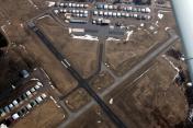
By: skypixsaerials


