Login
Register


MJQ
Jackson Municipal Airport
Official FAA Data Effective 2026-01-22 0901Z
Chart Supplement

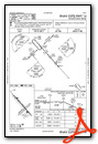
VFR Chart of KMJQ
Sectional Charts at SkyVector.com
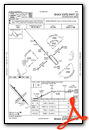
IFR Chart of KMJQ
Enroute Charts at SkyVector.com
Location Information for KMJQ
Coordinates: N43°39.05' / W94°59.19'Located 02 miles N of Jackson, Minnesota on 270 acres of land. View all Airports in Minnesota.
Surveyed Elevation is 1445 feet MSL.
Operations Data
|
|
Airport Communications
| AWOS-3: | 118.1 Tel. 507-847-5810 |
|---|---|
| UNICOM: | 122.800 |
| CTAF: | 122.800 |
| AWOS-3PT at MWM (16.4 N): | 119.325 507-831-1833 |
| ASOS at EST (18.0 SE): | 121.425 712-362-7250 |
| AWOS-3PT at FRM (24.8 E): | 120.025 507-238-1562 |
- APCH/DEP SVC PRVDD BY MINNEAPOLIS ARTCC ON FREQS 127.75/257.7. (FAIRMONT RCAG)
Nearby Navigation Aids
|
| ||||||||||||||||||||||||||||||||||||||||||||||||||||||||||||


Runway 14/32
| Dimensions: | 4145 x 75 feet / 1263 x 23 meters | |
|---|---|---|
| Surface: | Asphalt in Good Condition | |
| Weight Limits: | S-8, D-10 | |
| Edge Lighting: | Medium Intensity | |
| Runway 14 | Runway 32 | |
| Coordinates: | N43°39.34' / W94°59.53' | N43°38.83' / W94°58.91' |
| Elevation: | 1432.0 | 1445.7 |
| Traffic Pattern: | Left | Left |
| Runway Heading: | 138° True | 318° True |
| Displaced Threshold: | 541 Feet | 541 Feet |
| Declared Distances: | TORA:3600 TODA:3600 ASDA:4145 LDA:3600 | TORA:3600 TODA:3600 ASDA:4145 LDA:3600 |
| Markings: | Non-Precision Instrument in good condition. | Non-Precision Instrument in good condition. |
| Glide Slope Indicator | P4L (3.00° Glide Path Angle) RWY 14 PAPI UNUSBL BYD 6 DEGS LEFT OF CRS. | P4L (3.00° Glide Path Angle) |
| REIL: | Yes | Yes |
Runway 04/22
CLSD WINTER MONTHS. | ||
| Dimensions: | 2282 x 300 feet / 696 x 91 meters | |
|---|---|---|
| Surface: | Turf in Good Condition | |
| Runway 04 | Runway 22 | |
| Coordinates: | N43°38.84' / W94°59.33' | N43°39.10' / W94°58.96' |
| Elevation: | 1440.6 | 1442.8 |
| Traffic Pattern: | Left | Left |
| Runway Heading: | 47° True | 227° True |
| Obstacles: | 7 ft Crops 46 ft from runway, 129 ft right of center | |
Services Available
| Fuel: | 100LL (blue), Jet-A |
|---|---|
| Transient Storage: | Hangars,Tiedowns |
| Airframe Repair: | MAJOR |
| Engine Repair: | MAJOR |
| Bottled Oxygen: | NONE |
| Bulk Oxygen: | NONE |
| Other Services: | CROP DUSTING SERVICES,AIRCRAFT RENTAL |
Ownership Information
| Ownership: | Publicly owned | |
|---|---|---|
| Owner: | CITY OF JACKSON | |
| 80 W ASHLEY ST | ||
| JACKSON, MN 56143-1669 | ||
| 507-847-4410 | ||
| Manager: | PAUL SANDERS, PS AVIATION, INC. | |
| 150 COUNTY ROAD 34 E | ||
| JACKSON, MN 56143-3164 | ||
| 507-847-3599 | ||
Other Remarks
- GCO AVBL ON FREQ 121.725 THRU MINNEAPOLIS ARTCC & FLT SVCS
- ACCESS CODE TO A/D BLDG IS CTAF FREQ.
- FOR CD IF UNA VIA GCO CTC MINNEAPOLIS ARTCC AT 651-463-5588.
- YELLOW CONES.
- YELLOW CONES.
- 0LL FUEL AVBL H24 VIA CREDIT CARD.
- ACTVT OR INCR INTST REIL RWY 14 & 32; PAPI RWY 14 & 32; MIRL RWY 14/32 - CTAF. MIRL RWY 14/32 PRESET LOW INTST.
Weather Minimums


Instrument Approach Procedure (IAP) Charts
Nearby Airports with Instrument Procedures
| ID | Name | Heading / Distance | ||
|---|---|---|---|---|
 |
KMWM | Windom Municipal Airport | 341° | 16.6 |
|
KEST | Estherville Municipal Airport | 144° | 18.0 |
|
4D8 | Fuller Airport | 201° | 20.5 |
|
KFRM | Fairmont Municipal Airport | 090° | 24.9 |
|
KOTG | Worthington Municipal Airport | 270° | 25.8 |
|
KJYG | St James Municipal Airport | 042° | 27.4 |
|
KSPW | Spencer Municipal Airport | 198° | 30.6 |
|
D42 | Springfield Municipal Airport | 359° | 34.8 |
|
KEGQ | Emmetsburg Municipal Airport | 159° | 35.2 |
|
KISB | Sibley Municipal Airport | 243° | 37.7 |
|
KSBU | Blue Earth Municipal Airport | 094° | 39.1 |
|
KDVP | Slayton Municipal Airport | 300° | 40.0 |
Airport Images
Do you have a recent image of this airport? Upload it here!


