Login
Register


DLZ
Delaware Municipal/Jim Moore Field Airport
Official FAA Data Effective 2026-02-19 0901Z
Chart Supplement

VFR Chart of KDLZ
Sectional Charts at SkyVector.com
IFR Chart of KDLZ
Enroute Charts at SkyVector.com
Location Information for KDLZ
Coordinates: N40°16.77' / W83°6.80'Located 03 miles SW of Delaware, Ohio on 325 acres of land. View all Airports in Ohio.
Surveyed Elevation is 945 feet MSL.
Operations Data
|
|
Airport Communications
| AWOS-3: | 119.025 Tel. 740-203-1878 |
|---|---|
| COLUMBUS APPROACH: | 125.95 317.775 |
| COLUMBUS DEPARTURE: | 125.95 317.775 |
| IC: | 125.95 317.775 |
| UNICOM: | 122.700 |
| CTAF: | 122.700 |
| AWOS-3 at MRT (11.2 W): | 119.275 937-644-2967 |
| ATIS at OSU (12.2 S): | 121.35 |
| ASOS at OSU (12.2 S): | 121.35 614-451-2465 |
Nearby Navigation Aids
|
| ||||||||||||||||||||||||||||||||||||||||||||||||||||||||||||


Runway 10/28
| Dimensions: | 5800 x 100 feet / 1768 x 30 meters | |
|---|---|---|
| Surface: | Asphalt / Grooved in Good Condition | |
| Weight Limits: | 39 /F/C/X/T, S-100, D-139, ST-233 | |
| Edge Lighting: | Medium Intensity | |
| Runway 10 | Runway 28 | |
| Coordinates: | N40°16.84' / W83°7.42' | N40°16.70' / W83°6.19' |
| Elevation: | 944.2 | 944.7 |
| Traffic Pattern: | Left | Left |
| Runway Heading: | 98° True | 278° True |
| Markings: | Non-Precision Instrument in good condition. | Non-Precision Instrument in good condition. |
| Glide Slope Indicator | P4L (3.00° Glide Path Angle) | P4L (3.00° Glide Path Angle) PAPI UNUSBL BYD 8 DEGS RIGHT OF CNTRLN. |
| REIL: | Yes | Yes |
| Obstacles: | 144 ft Hill 3061 ft from runway, 314 ft right of center | 75 ft Trees 1476 ft from runway, 230 ft left of center |
Services Available
| Fuel: | 100LL (blue), Jet-A, Jet A+ |
|---|---|
| Transient Storage: | Hangars,Tiedowns PRIOR CDN RQRD. |
| Airframe Repair: | MAJOR |
| Engine Repair: | MAJOR |
| Bottled Oxygen: | LOW |
| Bulk Oxygen: | NONE |
| Other Services: | PILOT INSTRUCTION,AIRCRAFT RENTAL |
Ownership Information
| Ownership: | Publicly owned | |
|---|---|---|
| Owner: | CITY OF DELAWARE | |
| 1 S SANDUSKY ST | ||
| DELAWARE, OH 43015-2326 | ||
| 740-203-1800 | ||
| Manager: | KEVIN PIATT | |
| 1075 PITTSBURGH DR | ||
| DELAWARE, OH 43015-3848 | ||
| 740-203-1870 | AFT HRS 740-203-1870, OPTION 9. | |
Other Remarks
- OCNL DEER & OTR WILDLIFE ON & INVOF ARPT.
- INTMT NGT ACT AT QUARRY OFF WEST END OF RWY 10.
- ULTRALIGHT TFC RMN S OF RWY AT 400 FT AGL.
- FOR CD CTC COLUMBUS APCH AT 614-338-8537.
- CALM WIND RWY.
- ACTVT REIL RWY 10 & 28; PAPI RWY 10 & 28; MIRL RWY 10/28 - CTAF.
Weather Minimums

Instrument Approach Procedure (IAP) Charts

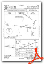

Nearby Airports with Instrument Procedures
| ID | Name | Heading / Distance | ||
|---|---|---|---|---|
 |
KMRT | Union County Airport | 253° | 11.4 |
|
KOSU | Ohio State University Airport | 171° | 12.1 |
|
4I9 | Morrow County Airport | 039° | 19.0 |
|
KCMH | John Glenn Columbus International Airport | 148° | 19.8 |
|
KMNN | Marion Municipal Airport | 006° | 20.3 |
|
KTZR | Bolton Field Airport | 182° | 22.7 |
|
KUYF | Madison County Airport | 217° | 26.3 |
|
4I3 | Knox County Airport | 083° | 27.1 |
|
KLCK | Rickenbacker International Airport | 162° | 29.2 |
|
I74 | Grimes Field Airport | 253° | 30.7 |
|
17G | Port Bucyrus/Crawford County Airport | 011° | 30.8 |
|
I95 | Hardin County Airport | 309° | 31.4 |
Airport Images

By: chadharris


