Login
Register


I74
Grimes Field Airport
Official FAA Data Effective 2026-02-19 0901Z
Chart Supplement

VFR Chart of I74
Sectional Charts at SkyVector.com
IFR Chart of I74
Enroute Charts at SkyVector.com
Location Information for I74
Coordinates: N40°7.94' / W83°45.24'Located 01 miles N of Urbana, Ohio on 329 acres of land. View all Airports in Ohio.
Surveyed Elevation is 1067 feet MSL.
Operations Data
|
|
Airport Communications
| AWOS-3: | 118.325 Tel. 937-484-5863 |
|---|---|
| COLUMBUS APPROACH: | 134.45 294.5 |
| COLUMBUS DEPARTURE: | 134.45 294.5 |
| IC: | 294.5 |
| CTAF: | 122.700 |
| UNICOM: | 122.700 |
| AWOS-3 at EDJ (14.7 N): | 118.075 937-599-4654 |
| AWOS-3PT at UYF (18.0 SE): | 120.85 740-852-2844 |
| AWOS-3PT at SGH (18.3 S): | 134.975 937-324-4532 |
Nearby Navigation Aids
|
| ||||||||||||||||||||||||||||||||||||||||||||||||||||||||||||


Runway 02/20
| Dimensions: | 4400 x 100 feet / 1341 x 30 meters | |
|---|---|---|
| Surface: | Asphalt in Fair Condition | |
| Edge Lighting: | Medium Intensity | |
| Runway 02 | Runway 20 | |
| Coordinates: | N40°7.61' / W83°45.36' | N40°8.30' / W83°45.07' |
| Elevation: | 1057.8 | 1067.5 |
| Traffic Pattern: | Left | Left |
| Runway Heading: | 18° True | 198° True |
| Markings: | Non-Precision Instrument in fair condition. | Non-Precision Instrument in fair condition. |
| Glide Slope Indicator | P4R (3.00° Glide Path Angle) | P4L (3.00° Glide Path Angle) |
| REIL: | Yes | Yes |
Runway 01/19
| Dimensions: | 3000 x 100 feet / 914 x 30 meters | |
|---|---|---|
| Surface: | Turf in Good Condition | |
| Runway 01 | Runway 19 | |
| Coordinates: | N40°7.68' / W83°45.33' | N40°8.17' / W83°45.25' |
| Elevation: | 1060.0 | 1060.0 |
| Runway Heading: | 8° True | 188° True |
| Markings: | in good condition. | in good condition. |
Services Available
| Fuel: | 100LL (blue), Jet A+ |
|---|---|
| Transient Storage: | Hangars,Tiedowns PRIOR CDN RQRD FOR HNGR. |
| Airframe Repair: | MINOR |
| Engine Repair: | MINOR |
| Bottled Oxygen: | NONE |
| Bulk Oxygen: | NONE |
| Other Services: | CROP DUSTING SERVICES,AIR AMBULANCE SERVICES,CHARTER SERVICE,PILOT INSTRUCTION |
Ownership Information
| Ownership: | Publicly owned | |
|---|---|---|
| Owner: | CITY OF URBANA | |
| 205 S MAIN ST | ||
| URBANA, OH 43078-2113 | ||
| 937-652-4304 | ||
| Manager: | DRAKE HUFFMAN | |
| 1636 N MAIN ST | ||
| URBANA, OH 43078-5001 | ||
| 937-652-4319 | CELL 740-995-9919. | |
Other Remarks
- FOR CD CTC COLUMBUS APCH AT 614-338-8537.
- BIRDS & DEER ON & INVOF ARPT.
- 125 FT WATER TWR, 1 NM SOUTH.
- CALM WIND RWY.
- YELLOW CONES.
- YELLOW CONES.
- 0LL 100LL & JET A+ AVBL H24 SELF SVC VIA CREDIT CARD.
- ACTVT REIL RWY 02 & 20; MIRL RWY 02/20 - CTAF.
Weather Minimums

Instrument Approach Procedure (IAP) Charts
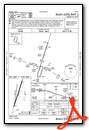

Nearby Airports with Instrument Procedures
| ID | Name | Heading / Distance | ||
|---|---|---|---|---|
 |
KEDJ | Bellefontaine Regional Airport | 348° | 14.7 |
|
KSGH | Springfield/Beckley Municipal Airport | 192° | 18.0 |
|
KUYF | Madison County Airport | 131° | 18.0 |
|
KSCA | Sidney Municipal Airport | 289° | 19.2 |
|
KMRT | Union County Airport | 073° | 19.3 |
|
KFFO | Wright-Patterson AFB Airport | 216° | 22.8 |
|
KDAY | James M Cox Dayton International Airport | 237° | 25.5 |
|
I17 | Piqua/Hartzell Field Airport | 274° | 25.6 |
|
KGDK | Greene County/Lewis A Jackson Regional Airport | 202° | 28.7 |
|
I95 | Hardin County Airport | 009° | 29.1 |
|
KDLZ | Delaware Municipal/Jim Moore Field Airport | 073° | 30.7 |
|
KOSU | Ohio State University Airport | 095° | 31.5 |

 from the northwest")


