Login
Register


DXX
Lac Qui Parle County Airport
Official FAA Data Effective 2026-01-22 0901Z
Chart Supplement

VFR Chart of KDXX
Sectional Charts at SkyVector.com
IFR Chart of KDXX
Enroute Charts at SkyVector.com
Location Information for KDXX
Coordinates: N44°59.19' / W96°10.67'Located 02 miles SE of Madison, Minnesota on 257 acres of land. View all Airports in Minnesota.
Surveyed Elevation is 1082 feet MSL.
Operations Data
|
|
Airport Communications
| AWOS-3: | 118.975 Tel. 320-598-3863 |
|---|---|
| CTAF: | 122.800 |
| UNICOM: | 122.800 |
| AWOS-3 at CNB (15.9 S): | 118.575 507-223-5293 |
| AWOS-3 at AQP (16.2 NE): | 118.5 320-289-1265 |
| AWOS-3PT at MVE (19.8 E): | 119.675 320-269-5830 |
- APCH/DEP SVC PRVDD BY MINNEAPOLIS ARTCC ON FREQS 128.5/306.2 (WATERTOWN RCAG).
Nearby Navigation Aids
|
| ||||||||||||||||||||||||||||||||||||||||||


Runway 14/32
| Dimensions: | 3300 x 75 feet / 1006 x 23 meters | |
|---|---|---|
| Surface: | Asphalt in Fair Condition | |
| Edge Lighting: | Medium Intensity | |
| Runway 14 | Runway 32 | |
| Coordinates: | N44°59.40' / W96°10.98' | N44°58.98' / W96°10.49' |
| Elevation: | 1082.5 | 1078.1 |
| Runway Heading: | 140° True | 320° True |
| Markings: | Non-Precision Instrument in good condition. | Non-Precision Instrument in good condition. |
| Glide Slope Indicator | P4L (3.00° Glide Path Angle) | P4L (3.00° Glide Path Angle) |
| REIL: | Yes | Yes |
Runway 09/27
NOT PLOWED WINTER MONTHS. | ||
| Dimensions: | 3003 x 135 feet / 915 x 41 meters | |
|---|---|---|
| Surface: | Turf in Good Condition | |
| Runway 09 | Runway 27 | |
| Coordinates: | N44°59.18' / W96°10.95' | N44°59.18' / W96°10.25' |
| Elevation: | 1077.9 | 1073.6 |
| Runway Heading: | 90° True | 270° True |
Services Available
| Fuel: | 100LL (blue) |
|---|---|
| Transient Storage: | Hangars,Tiedowns FOR HNGR CALL AMGR. |
| Airframe Repair: | NONE |
| Engine Repair: | NONE |
| Bottled Oxygen: | NONE |
| Bulk Oxygen: | NONE |
Ownership Information
| Ownership: | Publicly owned | |
|---|---|---|
| Owner: | MADISON/LAC QUI PARLE COUNTY | ALSO CITY OF MADISON AND LAC QUI PARLE COUNTY. |
| PO BOX 175 | ||
| MADISON, MN 56256-0175 | ||
| 320-320-9300 | ||
| Manager: | MICHAEL DAHLE | |
| PO BOX 175 | ||
| MADISON, MN 56256-0175 | ||
| 320-333-9300 | ||
Other Remarks
- FOR CD IF UNA TO CTC ON FSS FREQ, CTC MINNEAPOLIS ARTCC AT 651-463-5588.
- YELLOW CONES.
- YELLOW CONES.
- 0LL AVBL H24 VIA CREDIT CARD.
- ACTVT OR INCR INTST REIL RWY 14 & 32; PAPI RWY 14 & 32; MIRL RWY 14/32 - CTAF. MIRL RWY 14/32 PRESET LOW INTST SS-SR.
Weather Minimums


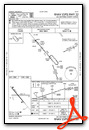
Instrument Approach Procedure (IAP) Charts

Nearby Airports with Instrument Procedures
| ID | Name | Heading / Distance | ||
|---|---|---|---|---|
 |
KCNB | Myers Field Airport | 193° | 15.9 |
|
KAQP | Appleton Municipal Airport | 026° | 16.2 |
|
KMVE | Montevideo-Chippewa County Airport | 092° | 19.9 |
|
KVVV | Ortonville Municipal/Martinson Field Airport | 331° | 21.8 |
|
1D1 | Milbank Municipal Airport | 311° | 22.1 |
|
KGDB | Granite Falls Municipal/Lenzen-Roe-Fagen Memorial Field Airport | 117° | 30.0 |
|
KBBB | Benson Municipal Airport | 047° | 30.5 |
|
KMML | Southwest Minnesota Regional Marshall/Ryan Field Airport | 154° | 35.5 |
|
KMOX | Morris Municipal/Charlie Schmidt Field Airport | 014° | 35.8 |
|
KATY | Watertown Regional Airport | 264° | 41.9 |
|
KBDH | Willmar Municipal/John L Rice Field Airport | 079° | 45.3 |
|
KBKX | Brookings Regional Airport | 214° | 49.3 |
Airport Images
Do you have a recent image of this airport? Upload it here!


