Login
Register


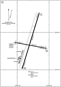
E26
Lea County/Jal Airport
Official FAA Data Effective 2026-02-19 0901Z
Chart Supplement

Airport Diagram
VFR Chart of E26
Sectional Charts at SkyVector.com
IFR Chart of E26
Enroute Charts at SkyVector.com
Location Information for E26
Coordinates: N32°7.86' / W103°9.29'Located 03 miles NE of Jal, New Mexico on 320 acres of land. View all Airports in New Mexico.
Surveyed Elevation is 3118 feet MSL.
Operations Data
|
|
Airport Communications
| CTAF: | 122.900 |
|---|---|
| ASOS at INK (21.2 S): | 118.325 432-527-3320 |
| ATIS at HOB (33.5 N): | 119.75 |
| AWOS-3 at HOB (33.5 N): | 575-393-8418 |
Nearby Navigation Aids
|
| ||||||||||||||||||||||||||||||||||||||||||||||||


Runway 01/19
| Dimensions: | 4704 x 60 feet / 1434 x 18 meters | |
|---|---|---|
| Surface: | Asphalt in Fair Condition | |
| Weight Limits: | 4 /F/C/Y/T, S-23 | |
| Edge Lighting: | Medium Intensity | |
| Runway 01 | Runway 19 | |
| Coordinates: | N32°7.51' / W103°9.42' | N32°8.26' / W103°9.16' |
| Elevation: | 3097.0 | 3104.0 |
| Traffic Pattern: | Left | Left |
| Runway Heading: | 17° True | 197° True |
| Markings: | Basic in fair condition. | Basic in fair condition. |
| Glide Slope Indicator | P2L (3.03° Glide Path Angle) | P2L (2.83° Glide Path Angle) |
| Obstacles: | 3 ft Brush 201 ft from runway, 120 ft right of center +2-3 FT BRUSH 0-200 FT FM THR 115-250 FT R & 100 FT L OF CNTRLN. |
12 ft Brush 300 ft from runway, 10 ft left of center +1-2 FT BRUSH 0-200 FT FM THR 80 FT L OF CNTRLN. |
Runway 09/27
+3-5 FT BRUSH 75-125 FT FM CNTRLN E SIDE. | ||
| Dimensions: | 2604 x 50 feet / 794 x 15 meters | |
|---|---|---|
| Surface: | Asphalt in Good Condition | |
| Weight Limits: | 3 /F/B/Y/T, S-12 | |
| Runway 09 | Runway 27 | |
| Coordinates: | N32°7.87' / W103°9.54' | N32°7.79' / W103°9.05' |
| Elevation: | 3118.0 | 3097.0 |
| Traffic Pattern: | Left | Left |
| Runway Heading: | 101° True | 281° True |
| Displaced Threshold: | 40 Feet | 45 Feet |
| Markings: | Basic in fair condition. | Basic in fair condition. |
| Obstacles: | 4 ft Brush 201 ft from runway APCH SLOPE 4:1 TO DTHR DUE TO +10 FT ROAD 40 FT FM DTHR. +4 FT FENCE 50 FT FM THR; +10 FT ROAD 40 FT FM THR. |
APCH SLOPE 5:1 TO DTHR DUE TO +10 FT ROAD 65 FT FM DTHR. +4 FT FENCE 15 FT FM RWY END; +5 FT BRUSH 20 FT FM RWY END; +10 FT ROAD 10 FT FM THR. |
Services Available
| Fuel: | NONE |
|---|---|
| Transient Storage: | Tiedowns |
| Airframe Repair: | NOT AVAILABLE |
| Engine Repair: | NOT AVAILABLE |
| Bottled Oxygen: | NOT AVAILABLE |
| Bulk Oxygen: | NOT AVAILABLE |
Ownership Information
| Ownership: | Publicly owned | |
|---|---|---|
| Owner: | LEA COUNTY | |
| PO BOX 1106 | ||
| HOBBS, NM 88241-1106 | ||
| 575-391-2934 | ||
| Manager: | CORY NEEDHAM | |
| PO BOX 1106 | ||
| HOBBS, NM 88241-1106 | ||
| 575-391-2934 | ||
Other Remarks
- LINE OF SIGHT BTN RWYS NA.
- OIL DRILLING ACT ON & INVOF ARPT.
- FOR CD CTC FORT WORTH ARTCC AT 817-858-7584.
- +3 FT POSTS 145 FT FM THR ON CENTERLINE & 40 FT L & 110 FT R OF CNTRLN.
- +20 FT PUMP JACK 990 FT FM THR 185 FT L OF CNTRLN.
- ACTVT PAPI RWY 01 & 19; MIRL RWY 01/19 - CTAF. MIRL RWY 01/19 PRESET LOW INTST - INCR INTST - CTAF.
Nearby Airports with Instrument Procedures
| ID | Name | Heading / Distance | ||
|---|---|---|---|---|
 |
KINK | Winkler County Airport | 186° | 21.2 |
|
KHOB | Lea County Regional Airport | 354° | 33.5 |
|
E11 | Andrews County Airport | 069° | 34.0 |
|
E01 | Roy Hurd Memorial Airport | 159° | 35.2 |
|
KODO | Odessa-Schlemeyer Field Airport | 107° | 41.1 |
|
KGNC | Gaines County Airport | 037° | 41.4 |
|
KPEQ | Pecos Municipal Airport | 202° | 48.4 |
|
KMAF | Midland International Air and Space Port Airport | 102° | 49.9 |
|
E06 | Lea County/Zip Franklin Memorial Airport | 345° | 50.9 |
|
KMDD | Midland Airpark Airport | 095° | 54.0 |
|
KCNM | Cavern City Air Trml Airport | 282° | 57.8 |
|
F98 | Yoakum County Airport | 014° | 67.1 |
Airport Images
Do you have a recent image of this airport? Upload it here!


