Login
Register
17K
Boise City Airport
Official FAA Data Effective 2025-11-27 0901Z
VFR Chart of 17K
Sectional Charts at SkyVector.com
IFR Chart of 17K
Enroute Charts at SkyVector.com
Location Information for 17K
Coordinates: N36°46.46' / W102°30.63'Located 03 miles N of Boise City, Oklahoma on 107 acres of land. View all Airports in Oklahoma.
Surveyed Elevation is 4174 feet MSL.
Operations Data
|
|
Airport Communications
| CTAF: | 122.900 |
|---|---|
| AWOS-3P at EHA (33.2 NE): | 118.025 620-697-4973 |
| ASOS at CAO (36.7 SW): | 120.625 575-446-3045 |
| AWOS-3PT at 8V7 (41.2 N): | 118.975 719-563-1028 |
- APCH/DEP SVC PRVDD BY ALBUQUERQUE ARTCC (ABQ) ON FREQS 127.85/285.475 (MOUNT DORA RCAG).
Nearby Navigation Aids
|
| ||||||||||||||||||||||||||||||||||||||||||||||||||||||
Runway 04/22
| Dimensions: | 4211 x 60 feet / 1284 x 18 meters | |
|---|---|---|
| Surface: | Asphalt in Excellent Condition | |
| Weight Limits: | S-4 | |
| Edge Lighting: | Medium Intensity | |
| Runway 04 | Runway 22 | |
| Coordinates: | N36°46.23' / W102°30.95' | N36°46.68' / W102°30.30' |
| Elevation: | 4171.7 | 4164.3 |
| Traffic Pattern: | Left | Left |
| Runway Heading: | 49° True | 229° True |
| Markings: | Non-Precision Instrument in good condition. | Non-Precision Instrument in good condition. |
| Glide Slope Indicator | P4L (3.00° Glide Path Angle) PAPI UNUSBL BYD 5 DEGS LEFT OF CNTRLN. | P4L (3.00° Glide Path Angle) |
| Obstacles: | 22 ft Trees 234 ft from runway, 204 ft right of center 20 FT TREELINE CROSSES RWY 04 APCH. |
15 ft Road 450 ft from runway |
Services Available
| Fuel: | 100LL (blue), Jet-A, Jet A+ |
|---|---|
| Transient Storage: | Tiedowns |
| Airframe Repair: | NONE |
| Engine Repair: | NONE |
| Bottled Oxygen: | NONE |
| Bulk Oxygen: | NONE |
| Other Services: | CROP DUSTING SERVICES |
Ownership Information
| Ownership: | Publicly owned | |
|---|---|---|
| Owner: | CITY OF BOISE CITY | |
| P.O. BOX 129, 23 N. LOGAN | ||
| BOISE CITY, OK 73933 | ||
| 580-544-2271 | ||
| Manager: | HERMEN ESPARANZA | |
| CITY HALL, P.O. BOX 129 | ||
| BOISE CITY, OK 73933 | ||
| 580-544-2271 | ||
Other Remarks
- FOR CD CTC ALBUQUERQUE ARTCC AT 505-856-4861.
- 0LL FUEL AVBL 24HRS W/ CC.
- ACTVT PAPI RWY 04 & 22 - CTAF. MIRL RWY 04/22 SS-SR; PRESET LOW INTST; INCR INTST - CTAF.
Weather Minimums
Instrument Approach Procedure (IAP) Charts
Nearby Airports with Instrument Procedures
| ID | Name | Heading / Distance | ||
|---|---|---|---|---|
 |
KEHA | Elkhart-Morton County Airport | 065° | 33.2 |
 |
KCAO | Clayton Municipal Airpark Airport | 237° | 36.6 |
 |
8V7 | Springfield Municipal Airport | 352° | 41.3 |
 |
KDHT | Dalhart Municipal Airport | 182° | 45.1 |
 |
KGUY | Guymon Municipal Airport | 096° | 48.7 |
 |
KHQG | Hugoton Municipal Airport | 066° | 59.6 |
 |
KDUX | Moore County Airport | 156° | 60.0 |
 |
KJHN | Stanton County Municipal Airport | 037° | 61.3 |
 |
E19 | Gruver Municipal Airport | 121° | 61.4 |
 |
E42 | Major Samuel B Cornelius Field Airport | 117° | 71.8 |
 |
KULS | Ulysses Airport | 047° | 73.8 |
 |
KLBL | Liberal Mid-America Regional Airport | 077° | 76.3 |


Comments
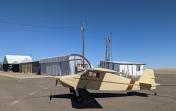
Welcome to the Twilight Zone
Okay for an emergency or to stretch your legs. The airport sits next to a busy highway a few miles outside of town. No facilities. The doors on the pilots lounge are screwed shut. Runway has large expansion cracks. Hangers are mostly decrepit. A sad little airport in need of TLC.