Login
Register


ELN
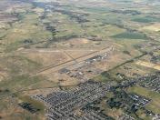
Bowers Field Airport
Official FAA Data Effective 2025-11-27 0901Z
Chart Supplement

VFR Chart of KELN
Sectional Charts at SkyVector.com
IFR Chart of KELN
Enroute Charts at SkyVector.com
Location Information for KELN
Coordinates: N47°2.09' / W120°31.73'Located 02 miles N of Ellensburg, Washington on 1301 acres of land. View all Airports in Washington.
Surveyed Elevation is 1763 feet MSL.
Operations Data
|
|
Airport Communications
| ASOS: | 118.375 Tel. 509-925-2040 |
|---|---|
| UNICOM: | 123.000 |
| CTAF: | 123.000 |
| ASOS at FCT (22.2 S): | 118.15 |
| ASOS at EAT (25.5 NE): | 119.925 509-886-4226 |
| ATIS at YKM (28.0 S): | 125.25 |
- APCH/DEP CTL SVC PRVDD BY SEATTLE ARTCC (ZSE) ON FREQS 132.6/269.35 (YAKIMA RCAG).
Nearby Navigation Aids
|
| ||||||||||||||||||||||||||||||||||||||||||


Runway 11/29
| Dimensions: | 4300 x 150 feet / 1311 x 46 meters HAS 1460 FT STOPWAY NW END. | |
|---|---|---|
| Surface: | Concrete in Good Condition | |
| Weight Limits: | S-35, D-57, ST-100 | |
| Edge Lighting: | Medium Intensity | |
| Runway 11 | Runway 29 | |
| Coordinates: | N47°2.33' / W120°32.11' | N47°1.85' / W120°31.35' |
| Elevation: | 1763.2 | 1747.0 |
| Traffic Pattern: | Left | Left |
| Runway Heading: | 133° True | 313° True |
| Markings: | Basic in fair condition. | Basic in fair condition. |
| Glide Slope Indicator | P4R (3.00° Glide Path Angle) | |
Services Available
| Fuel: | 100LL (blue), Jet-A |
|---|---|
| Transient Storage: | Tiedowns TIEDOWNS PILOT PROVIDED |
| Airframe Repair: | MAJOR |
| Engine Repair: | MAJOR |
| Bottled Oxygen: | NONE |
| Bulk Oxygen: | NONE |
| Other Services: | CHARTER SERVICE,PILOT INSTRUCTION |
Ownership Information
| Ownership: | Publicly owned | |
|---|---|---|
| Owner: | KITTITAS COUNTY | |
| 205 WEST 5TH AVE., SUITE 105 | ||
| ELLENSBURG, WA 98926 | ||
| 509-962-7523 | ||
| Manager: | JOSHUA FREDRICKSON | |
| 411 N. RUBY ST, SUITE #1 | ||
| ELLENSBURG, WA 98926 | ||
| 509-962-7523 | ||
Other Remarks
- TWY ALPHA, CHARLIE, ECHO CLSD.
- FOR CD IF UNA TO CTC ON FSS FREQ, CTC SEATTLE ARTCC AT 253-351-3694.
- DSTC TO GO MKRS NORTH SIDE OF RWY 11/29.
- 100LL AND JET A SELF SVC AVBL WITH CREDIT CARD. FS JET A AVBL UPON REQ.
- EXTENSIVE FLIGHT TRAINING AT OR BELOW 7500 FT' WITHIN 10 NM OF ELN (MONITOR 123.0)
- ACTVT MIRLS RWY 11/29; PAPI RWY 29 - CTAF.
Weather Minimums

Instrument Approach Procedure (IAP) Charts


Nearby Airports with Instrument Procedures
| ID | Name | Heading / Distance | ||
|---|---|---|---|---|
 |
KEAT | Pangborn Memorial Airport | 030° | 25.5 |
|
KYKM | Yakima Air Trml/Mcallister Field Airport | 181° | 28.0 |
|
KEPH | Ephrata Municipal Airport | 068° | 44.6 |
|
KMWH | Grant County International Airport | 077° | 50.7 |
|
KRLD | Richland Airport | 130° | 66.9 |
|
S50 | Auburn Municipal Airport | 284° | 71.7 |
|
KPLU | Pierce County/Thun Field Airport | 273° | 72.2 |
|
KRNT | Renton Municipal Airport | 292° | 74.2 |
|
KPSC | Tri-Cities Airport | 127° | 74.4 |
|
KSEA | Seattle-Tacoma International Airport | 289° | 77.0 |
|
KBFI | Boeing Field/King County International Airport | 292° | 78.3 |
|
3W7 | Grand Coulee Dam Airport | 047° | 79.4 |