
Login
Register


EOK
Keokuk Municipal Airport
Official FAA Data Effective 2026-01-22 0901Z
Chart Supplement
VFR Chart of KEOK
Sectional Charts at SkyVector.com
IFR Chart of KEOK
Enroute Charts at SkyVector.com
Location Information for KEOK
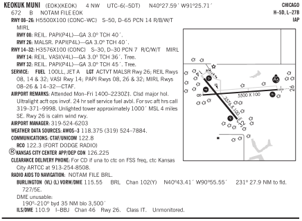
Coordinates: N40°27.59' / W91°25.71'Located 04 miles NW of Keokuk, Iowa on 372 acres of land. View all Airports in Iowa.
Surveyed Elevation is 671 feet MSL.
Operations Data
|
|
Airport Communications
| AWOS-3: | 118.375 Tel. 319-524-7884 |
|---|---|
| CTAF: | 122.800 |
| UNICOM: | 122.800 |
| AWOS-3 at FSW (12.8 N): | 120.925 319-372-5147 |
| ASOS at BRL (23.3 NE): | 118.025 319-752-6246 |
| AWOS-3 at MPZ (29.4 N): | 119.325 319-385-4926 |
- APCH/DEP SVC PRVDD BY KANSAS CITY ARTCC ON FREQS 126.225/317.775 (QUINCY RCAG).
Nearby Navigation Aids
|
| ||||||||||||||||||||||||||||||||||||||||||||||||||||||||||||


Runway 08/26
| Dimensions: | 5500 x 100 feet / 1676 x 30 meters | |
|---|---|---|
| Surface: | Concrete / Wire Combed in Good Condition | |
| Weight Limits: | 14 /R/B/W/T, S-50, D-65 | |
| Edge Lighting: | Medium Intensity | |
| Runway 08 | Runway 26 | |
| Coordinates: | N40°27.58' / W91°26.16' | N40°27.64' / W91°24.98' |
| Elevation: | 669.8 | 670.6 |
| Runway Heading: | 86° True | 266° True |
| Markings: | Precision Instrument in good condition. | Precision Instrument in good condition. |
| Glide Slope Indicator | P4L (3.00° Glide Path Angle) | P4L (3.00° Glide Path Angle) |
| Approach Lights: | MALSR 1,400 Foot Medium-intensity Approach Lighting System with runway alignment indicator lights. | |
| REIL: | Yes | |
Runway 14/32
| Dimensions: | 3576 x 100 feet / 1090 x 30 meters | |
|---|---|---|
| Surface: | Concrete in Good Condition | |
| Weight Limits: | 7 /R/C/W/T, S-30, D-30 | |
| Edge Lighting: | Medium Intensity | |
| Runway 14 | Runway 32 | |
| Coordinates: | N40°27.80' / W91°26.16' | N40°27.34' / W91°25.68' |
| Elevation: | 667.8 | 666.3 |
| Traffic Pattern: | Left | Left |
| Runway Heading: | 142° True | 322° True |
| Markings: | Non-Precision Instrument in good condition. | Non-Precision Instrument in good condition. |
| Glide Slope Indicator | V4L (3.00° Glide Path Angle) | P4L (3.00° Glide Path Angle) |
| REIL: | Yes | Yes |
| Obstacles: | 38 ft Tree 1064 ft from runway, 96 ft left of center | 46 ft Tree 1219 ft from runway, 60 ft right of center |
Services Available
| Fuel: | 100LL (blue), Jet-A |
|---|---|
| Transient Storage: | Tiedowns |
| Airframe Repair: | NONE |
| Engine Repair: | NONE |
| Bottled Oxygen: | NONE |
| Bulk Oxygen: | NONE |
Ownership Information
| Ownership: | Publicly owned | |
|---|---|---|
| Owner: | CITY OF KEOKUK | |
| 501 MAIN STREET | ||
| KEOKUK, IA 52632 | ||
| 319-524-2050 | ||
| Manager: | RAYMOND OTT | |
| 2504 340TH STREET | ||
| KEOKUK, IA 52632 | ||
| 319-524-6203 | ||
Other Remarks
- THIS AIRPORT HAS BEEN SURVEYED BY THE NATIONAL GEODETIC SURVEY.
- FOR SVC AFT HRS CALL 319-371-9998.
- UNLIGHTED TOWER APRXLY 1000 FT MSL 4 MILES SE.
- RY 26 IS CALM WIND RY.
- ULTRALIGHT AIRCRAFT OPERATIONS INVOF
- FOR CD IF UNA TO CTC ON FSS FREQ, CTC KANSAS CITY ARTCC AT 913-254-8508.
- ACTVT MALSR RWY 26; REIL RWYS 08, 14 & 32; VASI RWY 14; PAPI RWYS 08, 26 & 32; MIRL RWYS 08/26 & 14/32 - CTAF.
Weather Minimums


Instrument Approach Procedure (IAP) Charts

Nearby Airports with Instrument Procedures
| ID | Name | Heading / Distance | ||
|---|---|---|---|---|
 |
KFSW | Fort Madison Municipal Airport | 021° | 12.8 |
|
6M6 | Lewis County Regional Airport | 210° | 22.9 |
|
KBRL | Southeast Iowa Regional Airport | 035° | 23.8 |
|
KMPZ | Mount Pleasant Municipal Airport | 352° | 29.4 |
|
KUIN | Quincy Regional-Baldwin Field Airport | 160° | 32.9 |
|
KMQB | Macomb Municipal Airport | 083° | 35.7 |
|
03D | Memphis Memorial Airport | 269° | 36.6 |
|
I63 | Mount Sterling Municipal Airport | 134° | 40.4 |
|
KFFL | Fairfield Municipal Airport | 324° | 43.7 |
|
KHAE | Hannibal Regional Airport | 180° | 44.1 |
|
C66 | Monmouth Municipal Airport | 051° | 46.0 |
|
4K6 | Bloomfield Municipal Airport | 289° | 48.5 |
Airport Images

By: AirMarshall

By: rhjohn



Comments
Helpful FBO!
Keokuk is a wonderful place to stop. Got stuck here for a couple of days due to springtime weather. Unbelievably friendly helpful FBO staff. Looking forward to returning.
Taildragger1