Login
Register


HAE
Hannibal Regional Airport
Official FAA Data Effective 2026-02-19 0901Z
Chart Supplement

VFR Chart of KHAE
Sectional Charts at SkyVector.com
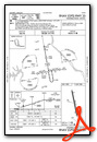
IFR Chart of KHAE
Enroute Charts at SkyVector.com
Location Information for KHAE
Coordinates: N39°43.51' / W91°26.63'Located 04 miles NW of Hannibal, Missouri on 400 acres of land. View all Airports in Missouri.
Surveyed Elevation is 768 feet MSL.
Operations Data
|
|
Airport Communications
| AWOS-3PT: | 120.775 Tel. 573-600-5226 |
|---|---|
| UNICOM: | 122.800 |
| CTAF: | 122.800 |
| ASOS at UIN (17.1 NE): | 121.425 217-885-3319 |
| AWOS-3T at PPQ (31.0 E): | 118.525 217-285-1428 |
| AWOS-3PT at I63 (33.5 NE): | 118.325 217-773-4082 |
- APCH/DEP SVC PRVDD BY KANSAS CITY ARTCC ON FREQS 126.225/317.775 (QUINCY RCAG).
Nearby Navigation Aids
|
| ||||||||||||||||||||||||||||||||||||||||||||||||||||||||||||


Runway 17/35
| Dimensions: | 4400 x 100 feet / 1341 x 30 meters | |
|---|---|---|
| Surface: | Concrete in Good Condition | |
| Weight Limits: | 7 /R/B/W/U, S-12 | |
| Edge Lighting: | Medium Intensity | |
| Runway 17 | Runway 35 | |
| Coordinates: | N39°43.87' / W91°26.71' | N39°43.15' / W91°26.55' |
| Elevation: | 758.0 | 767.8 |
| Traffic Pattern: | Left | Right |
| Runway Heading: | 170° True | 350° True |
| Markings: | Non-Precision Instrument in good condition. | Non-Precision Instrument in good condition. |
| Glide Slope Indicator | P4L (3.00° Glide Path Angle) | P4L (3.00° Glide Path Angle) |
| REIL: | Yes | Yes |
| Obstacles: | 55 ft Trees 1285 ft from runway, 415 ft right of center | |
Services Available
| Fuel: | 100LL (blue), Jet-A |
|---|---|
| Transient Storage: | Hangars,Tiedowns |
| Airframe Repair: | MAJOR |
| Engine Repair: | MAJOR |
| Bottled Oxygen: | NONE |
| Bulk Oxygen: | NONE |
| Other Services: | GLIDER SERVICE,PILOT INSTRUCTION,AIRCRAFT RENTAL,AIRCRAFT SALES,GLIDER TOWING SERVICES |
Ownership Information
| Ownership: | Publicly owned | |
|---|---|---|
| Owner: | CITY OF HANNIBAL | |
| 320 BROADWAY | ||
| HANNIBAL, MO 63401 | ||
| 573-221-0111 | ||
| Manager: | ANDY DORIAN | |
| CITY OF HANNIBAL, 6079 COUNTY ROAD 425 | ||
| HANNIBAL, MO 63401 | ||
| 573-406-3728 | ||
Other Remarks
- MAINTAIN CLEAR OF HOSPITAL AREA WHEN DEPARTING RWY 17.
- GLIDER ACTIVITY ON ARPT.
- DEER INVOF MOVEMENT AREAS.
- FOR CD CTC KANSAS CITY ARTCC AT 913-254-8508.
- ACTVT REIL RWY 17 AND 35; MIRL RWY 17/35 - CTAF. PAPI RWY 17 AND 35 OPR CONSLY.
Weather Minimums

Instrument Approach Procedure (IAP) Charts

Nearby Airports with Instrument Procedures
| ID | Name | Heading / Distance | ||
|---|---|---|---|---|
 |
K52 | Cpt Ben Smith Airfield/Monroe City Airport | 247° | 14.2 |
|
KUIN | Quincy Regional-Baldwin Field Airport | 041° | 17.4 |
|
H19 | Bowling Green Municipal Airport | 153° | 23.6 |
|
6M6 | Lewis County Regional Airport | 336° | 26.5 |
|
KPPQ | Pittsfield Penstone Municipal Airport | 099° | 31.2 |
|
I63 | Mount Sterling Municipal Airport | 061° | 33.4 |
|
KMYJ | Mexico Memorial Airport | 207° | 38.2 |
|
KEOK | Keokuk Municipal Airport | 000° | 44.1 |
|
K89 | Macon-Fower Memorial Airport | 270° | 46.9 |
|
KMBY | Omar N Bradley Airport | 251° | 48.2 |
|
KIRK | Kirksville Regional Airport | 293° | 55.4 |
|
KIJX | Jacksonville Municipal Airport | 086° | 55.9 |
Airport Images
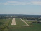
By: bcool


