Login
Register


FFM
Fergus Falls Municipal/Einar Mickelson Field Airport
Official FAA Data Effective 2025-11-27 0901Z
Chart Supplement

VFR Chart of KFFM
Sectional Charts at SkyVector.com
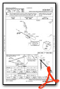
IFR Chart of KFFM
Enroute Charts at SkyVector.com
Location Information for KFFM
Coordinates: N46°17.06' / W96°9.40'Located 03 miles W of Fergus Falls, Minnesota on 731 acres of land. View all Airports in Minnesota.
Surveyed Elevation is 1182 feet MSL.
Operations Data
|
|
Airport Communications
| AWOS-3PT: | 119.05 Tel. 218-736-7216 |
|---|---|
| UNICOM: | 122.800 |
| CTAF: | 122.800 |
| AWOS-3 at BWP (18.9 W): | 127.875 701-642-9800 |
| AWOS-3 at Y63 (19.0 S): | 118.075 218-685-6456 |
| AWOS-3 at ETH (34.3 SW): | 118.775 320-563-4975 |
- APCH/DEP SVC PRVDD BY MINNEAPOLIS ARTCC ON FREQ 126.1/269.2 (ALEXANDRIA RCAG).
- COMMUNICATIONS PRVDD BY PRINCETON RADIO ON FREQ 122.6 (FERGUS FALLS RCO).
Nearby Navigation Aids
|
| ||||||||||||||||||||||||||||||||||||||||||||||||||||||


Runway 13/31
| Dimensions: | 5639 x 100 feet / 1719 x 30 meters | |
|---|---|---|
| Surface: | Asphalt in Good Condition | |
| Weight Limits: | S-60, D-90 | |
| Edge Lighting: | Medium Intensity | |
| Runway 13 | Runway 31 | |
| Coordinates: | N46°17.36' / W96°9.74' | N46°16.72' / W96°8.76' |
| Elevation: | 1181.7 | 1175.6 |
| Runway Heading: | 133° True | 313° True |
| Markings: | Precision Instrument in fair condition. | Precision Instrument in fair condition. |
| Glide Slope Indicator | P4L (3.00° Glide Path Angle) | P4L (3.00° Glide Path Angle) |
| Approach Lights: | MALSR 1,400 Foot Medium-intensity Approach Lighting System with runway alignment indicator lights. | |
| REIL: | Yes | |
Runway 17/35
| Dimensions: | 3299 x 75 feet / 1006 x 23 meters | |
|---|---|---|
| Surface: | Asphalt in Fair Condition | |
| Weight Limits: | S-16, D-22 | |
| Edge Lighting: | Medium Intensity | |
| Runway 17 | Runway 35 | |
| Coordinates: | N46°17.38' / W96°9.67' | N46°16.83' / W96°9.66' |
| Elevation: | 1182.2 | 1157.7 |
| Traffic Pattern: | Left | Left |
| Runway Heading: | 179° True | 359° True |
| Markings: | Non-Precision Instrument in fair condition. | Non-Precision Instrument in fair condition. |
| REIL: | Yes | |
Services Available
| Fuel: | 100LL (blue), Jet-A |
|---|---|
| Transient Storage: | Hangars,Tiedowns |
| Airframe Repair: | MINOR |
| Engine Repair: | MINOR |
| Bottled Oxygen: | NONE |
| Bulk Oxygen: | NONE |
| Other Services: | CROP DUSTING SERVICES,AIRCRAFT RENTAL,AIRCRAFT SALES |
Ownership Information
| Ownership: | Publicly owned | |
|---|---|---|
| Owner: | CITY OF FERGUS FALLS | |
| 112 W WASHINGTON AVE, PO BOX 868 | ||
| FERGUS FALLS, MN 56537-2568 | ||
| 218-332-5435 | ||
| Manager: | SKY CREW SERVICES | |
| 4005 STATE HIGHWAY 210 W | ||
| FERGUS FALLS, MN 56537-4005 | ||
| 218-739-3733 | ||
Other Remarks
- DEER & WATERFOWL ON & INVOF ARPT.
- ULTRALIGHTS ON & INVOF ARPT. ULTRALIGHT PATTERN 1800 FT MSL.
- FOR CD IF UNA TO CTC ON FSS FREQ, CTC MINNEAPOLIS ARTCC AT 651-463-5588.
- 0LL FUEL AVBL H24 VIA CREDIT CARD.
- ACTVT MALSR RWY 31; REIL RWY 13 & 35; PAPI RWY 13 & 31; MIRL RWY 13/31 & 17/35 - CTAF.
Weather Minimums

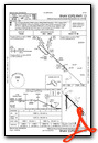
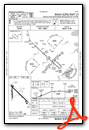
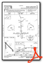
Instrument Approach Procedure (IAP) Charts

Nearby Airports with Instrument Procedures
| ID | Name | Heading / Distance | ||
|---|---|---|---|---|
 |
KBWP | Harry Stern Airport | 262° | 18.9 |
|
Y63 | Elbow Lake Municipal/Pride of The Prairie Airport | 158° | 19.3 |
|
16D | Perham Municipal Airport | 049° | 30.1 |
|
KDTL | Detroit Lakes/Wething Field Airport | 019° | 34.3 |
|
KETH | Wheaton Municipal Airport | 208° | 34.3 |
|
04Y | Hawley Municipal Airport | 347° | 36.9 |
|
KJKJ | Moorhead Municipal/Florence Klingensmith Field Airport | 327° | 39.4 |
|
KADC | Wadena Municipal Airport | 075° | 40.5 |
|
KAXN | Alexandria Regional/Chandler Field Airport | 127° | 40.5 |
|
K74 | Robert Odegaard Field Airport | 302° | 41.2 |
|
KMOX | Morris Municipal/Charlie Schmidt Field Airport | 169° | 44.0 |
|
KFAR | Hector International Airport | 324° | 46.9 |
Fuel Providers

Airport Images
Do you have a recent image of this airport? Upload it here!


