Login
Register


82V
Pine Bluffs Municipal Airport
Official FAA Data Effective 2025-12-25 0901Z
Chart Supplement

VFR Chart of 82V
Sectional Charts at SkyVector.com
IFR Chart of 82V
Enroute Charts at SkyVector.com
Location Information for 82V
Coordinates: N41°9.15' / W104°8.08'Located 03 miles SW of Pine Bluffs, Wyoming on 320 acres of land. View all Airports in Wyoming.
Surveyed Elevation is 5152 feet MSL.
Operations Data
|
|
Airport Communications
| AWOS-3PT: | 132.425 Tel. 307-245-3613 |
|---|---|
| UNICOM: | 122.800 |
| CTAF: | 122.800 |
| AWOS-3 at IBM (20.8 E): | 118.075 308-235-2516 |
| ATIS at CYS (30.5 W): | 134.425 |
| ASOS at CYS (30.5 W): | 307-475-6953 |
- APCH/DEP SVC PRVDD BY DENVER ARTCC (ZDV) ON FREQS 125.9/284.7 (CHEYENNE RCAG).
Nearby Navigation Aids
|
| ||||||||||||||||||||||||||||||||||||||||||||||||||||||||||||


Runway 08/26
| Dimensions: | 5330 x 75 feet / 1625 x 23 meters | |
|---|---|---|
| Surface: | Asphalt in Good Condition | |
| Weight Limits: | 20 /F/A/X/U, S-12 | |
| Edge Lighting: | Medium Intensity | |
| Runway 08 | Runway 26 | |
| Coordinates: | N41°9.15' / W104°8.67' | N41°9.15' / W104°7.51' |
| Elevation: | 5152.1 | 5129.0 |
| Traffic Pattern: | Left | Left |
| Markings: | Non-Precision Instrument in good condition. | Non-Precision Instrument in good condition. |
| Glide Slope Indicator | P2L (3.00° Glide Path Angle) | P2L (3.00° Glide Path Angle) |
| REIL: | Yes | Yes |
Services Available
| Fuel: | 100LL (blue) |
|---|---|
| Transient Storage: | Hangars,Tiedowns PILOT SUPPLIED ROPES RQRD. |
| Airframe Repair: | MAJOR |
| Engine Repair: | MAJOR |
| Bottled Oxygen: | NONE |
| Bulk Oxygen: | NONE |
| Other Services: | CROP DUSTING SERVICES,PILOT INSTRUCTION |
Ownership Information
| Ownership: | Publicly owned | |
|---|---|---|
| Owner: | TOWN OF PINE BLUFFS | |
| BOX 429 | ||
| PINE BLUFFS, WY 82082 | ||
| 307-245-3746 | ||
| Manager: | KEVIN MARQUARDT | |
| BOX 726 | ||
| PINE BLUFFS, WY 82082 | ||
| 307-338-5118 | ||
Other Remarks
- FOR CD CTC DENVER ARTCC AT 303-651-4257.
- 0LL FUEL AVBL 24 HOURS A DAY WITH CREDIT CARD SELF SERVE.
- ACTVT MIRL RY 08/26, PAPI RYS 08 & 26, REIL RYS 08 & 26 & WIND TEE - 122.8.
Weather Minimums

Instrument Approach Procedure (IAP) Charts

Nearby Airports with Instrument Procedures
| ID | Name | Heading / Distance | ||
|---|---|---|---|---|
 |
KIBM | Kimball Municipal/Robert E Arraj Field Airport | 083° | 20.8 |
|
KCYS | Cheyenne Regional/Jerry Olson Field Airport | 270° | 30.6 |
|
KGXY | Greeley-Weld County Airport | 208° | 48.5 |
|
KBFF | Scottsbluff/Western Nebraska Regional/Wm B Heilig Field Airport | 029° | 49.6 |
|
KSTK | Sterling Municipal Airport | 128° | 51.1 |
|
KFMM | Fort Morgan Municipal Airport | 162° | 51.3 |
|
KSNY | Sidney Municipal/Lloyd W Carr Field Airport | 093° | 52.2 |
|
KTOR | Torrington Municipal Airport | 359° | 54.7 |
|
KFNL | Northern Colorado Regional Airport | 223° | 58.0 |
|
KEAN | Phifer Airfield Airport | 326° | 64.9 |
|
KLAR | Laramie Regional Airport | 278° | 70.4 |
|
KGUR | Camp Guernsey Airport | 338° | 71.6 |
Airport Images
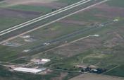
By: edz


