Login
Register


GA87
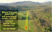
High Valley Airpark Airport
Official FAA Data Effective 2026-01-22 0901Z
VFR Chart of GA87
Sectional Charts at SkyVector.com
IFR Chart of GA87
Enroute Charts at SkyVector.com
Location Information for GA87
Coordinates: N34°41.89' / W84°0.76'Located 00 miles N of Suches, Georgia on 40 acres of land. View all Airports in Georgia.
Estimated Elevation is 2800 feet MSL.
Operations Data
|
|
Airport Communications
| AWOS-3PT at DZJ (9.4 N): | 119.325 706-745-9271 |
|---|---|
| AWOS-3 at AJR (25.7 SE): | 119.175 706-778-3675 |
| AWOS-3 at 49A (25.7 W): | 118.075 706 276-4513 |
Nearby Navigation Aids
|
| ||||||||||||||||||||||||||||||||||||||||||||||||||||||||||||


Runway 02/20
| Dimensions: | 2000 x 60 feet / 610 x 18 meters | |
|---|---|---|
| Surface: | Turf in Good Condition | |
| Runway 02 | Runway 20 | |
| Traffic Pattern: | Right | |
Ownership Information
| Ownership: | Privately Owned | |
|---|---|---|
| Owner: | HIGH VALLEY LAND LLC | |
| 1173 CANTON ST | ||
| ROSWELL, GA 30075 | ||
| 678-925-5424 | ||
| Manager: | JERE WOOD | |
| 1173 CANTON ST. | ||
| ROSWELL, GA 30075 | ||
| 678-925-5424 | ||
Other Remarks
- FOR CD CTC ATLANTA ARTCC AT 770-210-7692.
Nearby Airports with Instrument Procedures
| ID | Name | Heading / Distance | ||
|---|---|---|---|---|
 |
KDZJ | Blairsville Airport | 004° | 9.4 |
|
1A3 | Martin Campbell Field Airport | 319° | 25.2 |
|
KAJR | Habersham County Airport | 117° | 25.5 |
|
49A | Gilmer County Airport | 260° | 25.8 |
|
KJZP | Pickens County Airport | 236° | 26.5 |
|
KGVL | Lee Gilmer Memorial Airport | 160° | 27.0 |
|
KRHP | Western Carolina Regional Airport | 013° | 30.7 |
|
KCNI | Cherokee County Regional Airport | 221° | 30.8 |
|
KTOC | Toccoa Rg Letourneau Field Airport | 099° | 36.0 |
|
KJCA | Jackson County Airport | 144° | 38.5 |
|
KDNN | Dalton Municipal Airport | 272° | 42.4 |
|
1A5 | Macon County Airport | 042° | 42.9 |
Airport Images

By: Big Orange Bird
By: 185WB


