Login
Register


GDV
Dawson Community Airport
Official FAA Data Effective 2026-01-22 0901Z
Chart Supplement

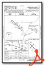
KGDV Airport Diagram

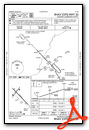
VFR Chart of KGDV
Sectional Charts at SkyVector.com
IFR Chart of KGDV
Enroute Charts at SkyVector.com
Location Information for KGDV
Coordinates: N47°8.32' / W104°48.43'Located 04 miles NW of Glendive, Montana on 413 acres of land. View all Airports in Montana.
Surveyed Elevation is 2458 feet MSL.
Operations Data
|
|
Airport Communications
| AWOS-3PT: | 135.075 Tel. 406-687-3346 |
|---|---|
| UNICOM: | 122.800 |
| CTAF: | 122.800 |
| AWOS-2 at 4U6 (35.1 NW): | 119.025 406-485-3760 |
| AWOS-3 at 20U (36.1 E): | 118.175 701-872-9225 |
| AWOS-3PT at SDY (42.0 NE): | 119.275 406-482-7323 |
- APCH/DEP CTL SVC PRVDD BY SALT LAKE ARTCC (ZLC) ON 126.85/305.2 (WATFORD CITY RCAG).
Nearby Navigation Aids
|
| ||||||||||||||||||||||||

Runway 12/30
| Dimensions: | 5704 x 100 feet / 1739 x 30 meters | |
|---|---|---|
| Surface: | Asphalt / Grooved in Good Condition | |
| Weight Limits: | S-38, D-50 | |
| Edge Lighting: | Medium Intensity | |
| Runway 12 | Runway 30 | |
| Coordinates: | N47°8.60' / W104°48.81' | N47°7.92' / W104°47.86' |
| Elevation: | 2458.3 | 2454.2 |
| Traffic Pattern: | Left | Left |
| Runway Heading: | 136° True | 316° True |
| Declared Distances: | TORA:5704 TODA:5704 ASDA:5704 LDA:5704 | TORA:5704 TODA:5704 ASDA:5704 LDA:5704 |
| Markings: | Non-Precision Instrument in good condition. | Non-Precision Instrument in good condition. |
| Glide Slope Indicator | V4L (3.00° Glide Path Angle) | V4L (3.00° Glide Path Angle) |
| REIL: | Yes | Yes |
Runway 02/20
| Dimensions: | 3002 x 60 feet / 915 x 18 meters | |
|---|---|---|
| Surface: | Asphalt in Good Condition TWY A HAS EDGE LIPS EXCEEDING 3 IN. | |
| Edge Lighting: | Medium Intensity | |
| Runway 02 | Runway 20 | |
| Coordinates: | N47°8.24' / W104°48.82' | N47°8.63' / W104°48.40' |
| Elevation: | 2456.1 | 2453.8 |
| Traffic Pattern: | Left | Left |
| Runway Heading: | 36° True | 216° True |
| Declared Distances: | TORA:3002 TODA:3002 ASDA:3002 LDA:3002 | TORA:3002 TODA:3002 ASDA:3002 LDA:3002 |
| Markings: | Basic in good condition. | Basic in good condition. |
| Glide Slope Indicator | P2L (3.00° Glide Path Angle) | P2L (3.00° Glide Path Angle) |
Services Available
| Fuel: | 100LL (blue), Jet A+ |
|---|---|
| Transient Storage: | Hangars,Tiedowns |
| Airframe Repair: | MINOR |
| Engine Repair: | MINOR |
| Bottled Oxygen: | NONE |
| Bulk Oxygen: | NONE |
| Other Services: | CROP DUSTING SERVICES |
Ownership Information
| Ownership: | Publicly owned | |
|---|---|---|
| Owner: | DAWSON COUNTY | |
| 207 WEST BELL | ||
| GLENDIVE, MT 59330 | ||
| (406) 377-3058 | ||
| Manager: | CRAIG HOSTETLER | |
| 207 WEST BELL | ||
| GLENDIVE, MT 59330 | ||
| 406-989-2054 | AFTER HRS CONTACT AMGR 406-989-2054. | |
Other Remarks
- AIRFIELD SURFACE CONDITIONS UNMONITORED 0100-1100 NOV-MAY.
- FOR CD IF UNA TO CTC ON FSS FREQ, CTC SALT LAKE ARTCC AT 801-320-2568.
- ACTIVATE MIRL RWY 02-20 AND RWY 12-30, PAPI RWY 02 AND RWY 20, REIL RWY 12 AND RWY 30 - CTAF. VASI RY 12/30 OPER CONTINUOUSLY.
Weather Minimums

Instrument Approach Procedure (IAP) Charts
Nearby Airports with Instrument Procedures
| ID | Name | Heading / Distance | ||
|---|---|---|---|---|
 |
4U6 | Circle Town County Airport | 298° | 35.1 |
|
20U | Beach Airport | 110° | 36.2 |
|
KSDY | Sidney-Richland Regional Airport | 036° | 42.3 |
|
KBHK | Baker Municipal Airport | 154° | 52.7 |
|
PO1 | Poplar Municipal Airport | 346° | 61.5 |
|
KMLS | Frank Wiley Field Airport | 226° | 61.7 |
|
KOLF | L M Clayton Airport | 331° | 65.3 |
|
S25 | Watford City Municipal Airport | 057° | 74.6 |
|
97M | Ekalaka Airport | 171° | 76.6 |
|
KXWA | Williston Basin International Airport | 032° | 79.8 |
|
9Y1 | Dunn County Weydahl Field Airport | 078° | 84.5 |
|
KDIK | Dickinson/Theodore Roosevelt Regional Airport | 103° | 84.8 |
Airport Images
Do you have a recent image of this airport? Upload it here!


